Mediapolis Topo Map Iowa
To zoom in, hover over the map of Mediapolis
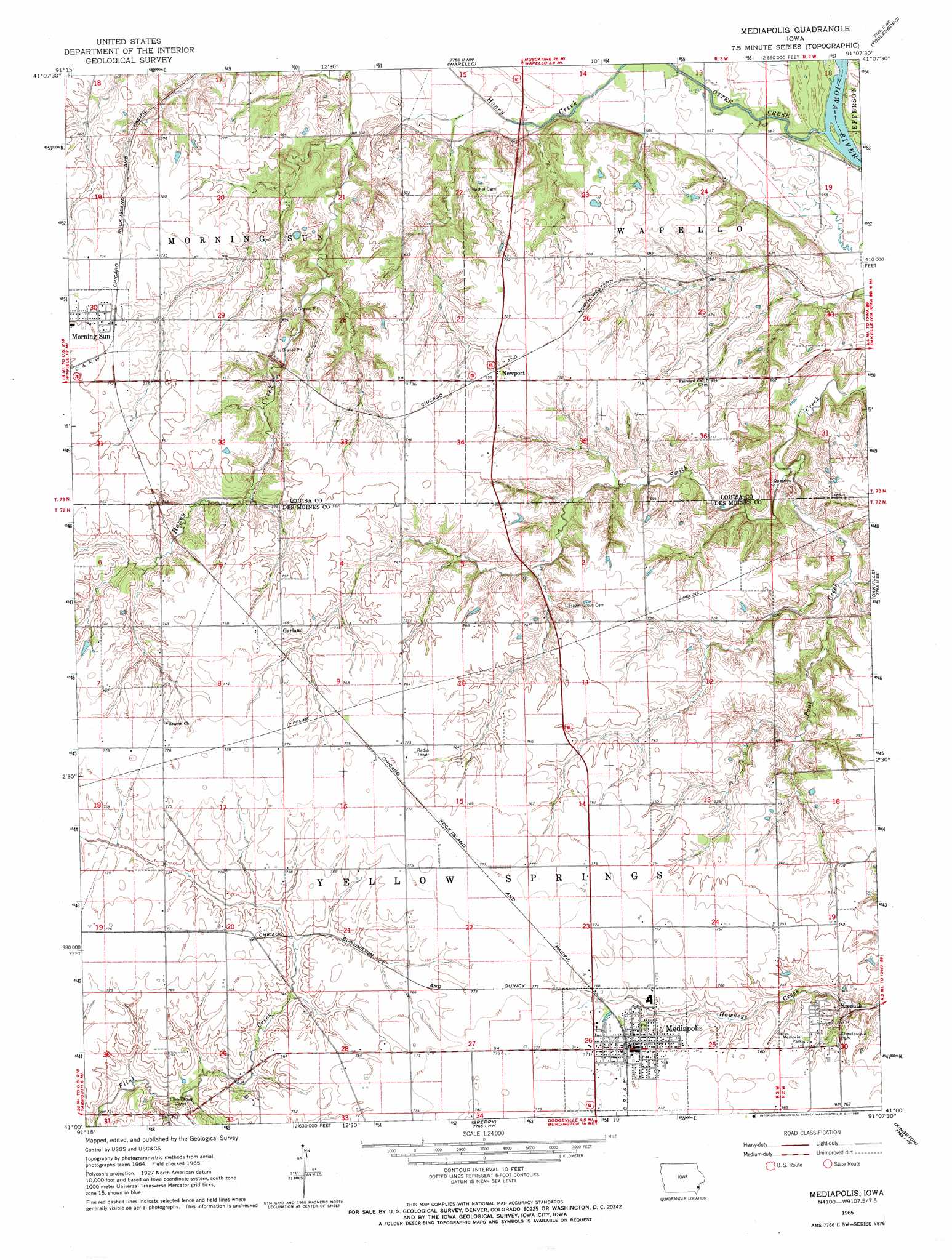
USGS Topo Quad 41091a2 - 1:24,000 scale
| Topo Map Name: | Mediapolis |
| USGS Topo Quad ID: | 41091a2 |
| Print Size: | ca. 21 1/4" wide x 27" high |
| Southeast Coordinates: | 41° N latitude / 91.125° W longitude |
| Map Center Coordinates: | 41.0625° N latitude / 91.1875° W longitude |
| U.S. State: | IA |
| Filename: | o41091a2.jpg |
| Download Map JPG Image: | Mediapolis topo map 1:24,000 scale |
| Map Type: | Topographic |
| Topo Series: | 7.5´ |
| Map Scale: | 1:24,000 |
| Source of Map Images: | United States Geological Survey (USGS) |
| Alternate Map Versions: |
Mediapolis IA 1965, updated 1966 Download PDF Buy paper map Mediapolis IA 2010 Download PDF Buy paper map Mediapolis IA 2013 Download PDF Buy paper map Mediapolis IA 2015 Download PDF Buy paper map |
1:24,000 Topo Quads surrounding Mediapolis
Cotter |
Columbus Junction |
Letts |
Blanchard Island |
Eliza |
Winfield North |
Cairo |
Wapello |
Toolesboro |
Joy |
Winfield South |
Morning Sun |
Mediapolis |
Oakville |
Keithsburg |
New London |
Pleasant Grove |
Sperry |
Kingston |
Oquawka |
Lowell |
Danville |
West Burlington |
Burlington |
Gladstone |
> Back to 41091a1 at 1:100,000 scale
> Back to 41090a1 at 1:250,000 scale
> Back to U.S. Topo Maps home
Mediapolis topo map: Gazetteer
Mediapolis: Airports
Keitzer Field elevation 228m 748′Mediapolis: Parks
Baird Timber elevation 215m 705′Cartwright Park elevation 232m 761′
Chautauqua Park elevation 229m 751′
Mediapolis: Populated Places
Garland elevation 233m 764′Kossuth elevation 230m 754′
Mediapolis elevation 235m 770′
Newport elevation 220m 721′
Mediapolis: Post Offices
Kossuth Post Office (historical) elevation 230m 754′Linton Post Office (historical) elevation 225m 738′
Mediapolis Post Office elevation 235m 770′
Newport Post Office (historical) elevation 220m 721′
Mediapolis: Streams
Otter Creek elevation 168m 551′Paul Creek elevation 180m 590′
Mediapolis digital topo map on disk
Buy this Mediapolis topo map showing relief, roads, GPS coordinates and other geographical features, as a high-resolution digital map file on DVD: