Richland Topo Map Iowa
To zoom in, hover over the map of Richland
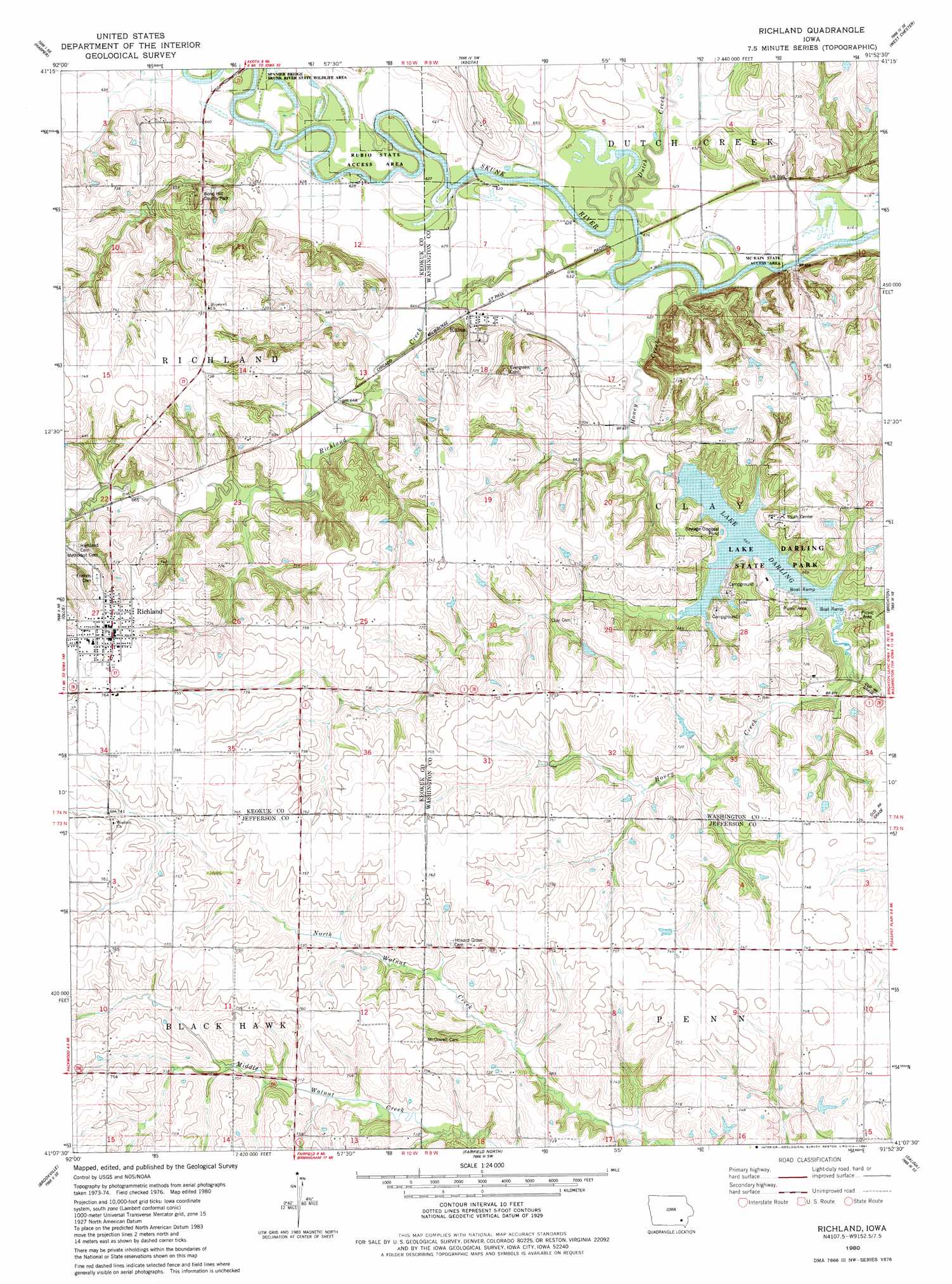
USGS Topo Quad 41091b8 - 1:24,000 scale
| Topo Map Name: | Richland |
| USGS Topo Quad ID: | 41091b8 |
| Print Size: | ca. 21 1/4" wide x 27" high |
| Southeast Coordinates: | 41.125° N latitude / 91.875° W longitude |
| Map Center Coordinates: | 41.1875° N latitude / 91.9375° W longitude |
| U.S. State: | IA |
| Filename: | o41091b8.jpg |
| Download Map JPG Image: | Richland topo map 1:24,000 scale |
| Map Type: | Topographic |
| Topo Series: | 7.5´ |
| Map Scale: | 1:24,000 |
| Source of Map Images: | United States Geological Survey (USGS) |
| Alternate Map Versions: |
Richland IA 1980, updated 1981 Download PDF Buy paper map Richland IA 2010 Download PDF Buy paper map Richland IA 2013 Download PDF Buy paper map Richland IA 2015 Download PDF Buy paper map |
1:24,000 Topo Quads surrounding Richland
Keswick |
South English |
Kinross |
Wellman |
Kalona |
Sigourney |
Harper |
Keota |
West Chester |
Washington |
Pekin |
Ollie |
Richland |
Brighton |
Wayland |
Abingdon |
Brookville |
Fairfield North |
Salina |
Trenton |
Eldon |
Libertyville |
Fairfield South |
Lockridge West |
Lockridge East |
> Back to 41091a1 at 1:100,000 scale
> Back to 41090a1 at 1:250,000 scale
> Back to U.S. Topo Maps home
Richland topo map: Gazetteer
Richland: Areas
Rubio State Access Area elevation 191m 626′Richland: Bridges
Rubio Bridge elevation 188m 616′Richland: Parks
Bond Hill County Park elevation 207m 679′Lake Darling State Park elevation 208m 682′
Richland: Populated Places
Richland elevation 235m 770′Rubio elevation 195m 639′
Veo elevation 226m 741′
Richland: Post Offices
Brays Post Office (historical) elevation 229m 751′Clay Post Office (historical) elevation 211m 692′
Richland Post Office elevation 236m 774′
Rubio Post Office (historical) elevation 195m 639′
Veo Post Office (historical) elevation 226m 741′
Woolson Post Office (historical) elevation 229m 751′
Richland: Reservoirs
Lake Darling elevation 200m 656′Richland: Streams
Dutch Creek elevation 189m 620′Honey Creek elevation 193m 633′
Richland Creek elevation 185m 606′
Richland digital topo map on disk
Buy this Richland topo map showing relief, roads, GPS coordinates and other geographical features, as a high-resolution digital map file on DVD: