Ely Topo Map Iowa
To zoom in, hover over the map of Ely
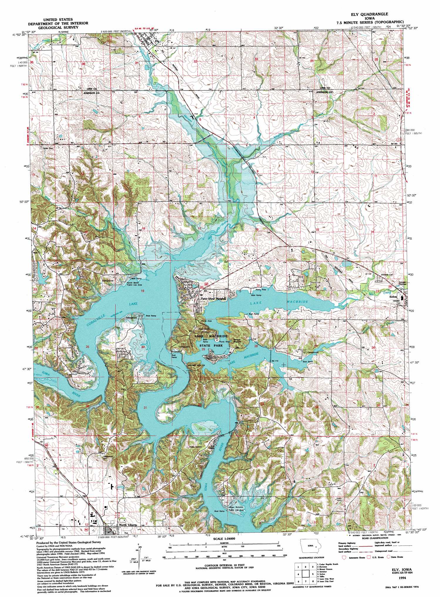
USGS Topo Quad 41091g5 - 1:24,000 scale
| Topo Map Name: | Ely |
| USGS Topo Quad ID: | 41091g5 |
| Print Size: | ca. 21 1/4" wide x 27" high |
| Southeast Coordinates: | 41.75° N latitude / 91.5° W longitude |
| Map Center Coordinates: | 41.8125° N latitude / 91.5625° W longitude |
| U.S. State: | IA |
| Filename: | o41091g5.jpg |
| Download Map JPG Image: | Ely topo map 1:24,000 scale |
| Map Type: | Topographic |
| Topo Series: | 7.5´ |
| Map Scale: | 1:24,000 |
| Source of Map Images: | United States Geological Survey (USGS) |
| Alternate Map Versions: |
Ely IA 1968, updated 1970 Download PDF Buy paper map Ely IA 1968, updated 1974 Download PDF Buy paper map Ely IA 1968, updated 1976 Download PDF Buy paper map Ely IA 1968, updated 1986 Download PDF Buy paper map Ely IA 1994, updated 1994 Download PDF Buy paper map Ely IA 2010 Download PDF Buy paper map Ely IA 2013 Download PDF Buy paper map Ely IA 2015 Download PDF Buy paper map |
1:24,000 Topo Quads surrounding Ely
Shellsburg |
Cedar Rapids North |
Marion |
Springville |
Anamosa |
Fairfax |
Cedar Rapids South |
Bertram |
Mount Vernon |
Mechanicsville |
Amana |
Swisher |
Ely |
Solon |
Cedar Bluff |
Oxford |
Tiffin |
Iowa City West |
Iowa City East |
West Branch |
Amish |
Williamstown |
Hills |
West Liberty Sw |
West Liberty |
> Back to 41091e1 at 1:100,000 scale
> Back to 41090a1 at 1:250,000 scale
> Back to U.S. Topo Maps home
Ely topo map: Gazetteer
Ely: Parks
Ely Town Bell Historical Marker elevation 225m 738′Lake Macbride State Park elevation 233m 764′
Sandy Beach Public Use Area elevation 223m 731′
Sugar Bottoms Public Use Area elevation 212m 695′
Ely: Populated Places
Ely elevation 225m 738′Golf View Mobile Home Court elevation 241m 790′
Twin View Heights elevation 243m 797′
Ely: Post Offices
Banner Valley Post Office (historical) elevation 233m 764′Ely Post Office elevation 224m 734′
Hoosier Grove Post Office (historical) elevation 233m 764′
Ely: Reservoirs
Lake McBride elevation 219m 718′Ely: Streams
Hoosier Creek elevation 208m 682′Jordan Creek elevation 218m 715′
Lingle Creek elevation 210m 688′
Mill Creek elevation 219m 718′
West Hoosier Creek elevation 210m 688′
Ely: Trails
Lake MacBride State Park Trail elevation 223m 731′Ely digital topo map on disk
Buy this Ely topo map showing relief, roads, GPS coordinates and other geographical features, as a high-resolution digital map file on DVD: