Mount Vernon Topo Map Iowa
To zoom in, hover over the map of Mount Vernon
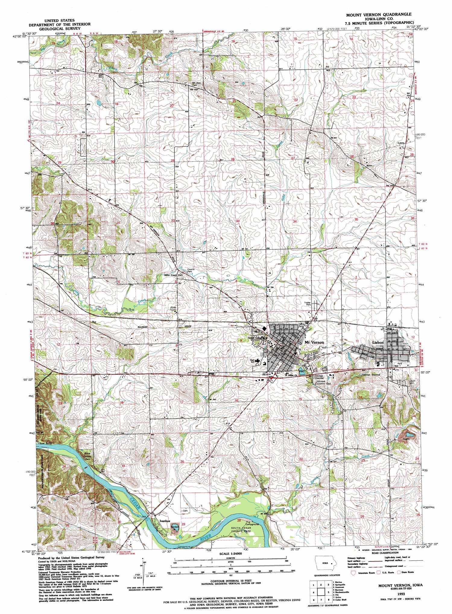
USGS Topo Quad 41091h4 - 1:24,000 scale
| Topo Map Name: | Mount Vernon |
| USGS Topo Quad ID: | 41091h4 |
| Print Size: | ca. 21 1/4" wide x 27" high |
| Southeast Coordinates: | 41.875° N latitude / 91.375° W longitude |
| Map Center Coordinates: | 41.9375° N latitude / 91.4375° W longitude |
| U.S. State: | IA |
| Filename: | o41091h4.jpg |
| Download Map JPG Image: | Mount Vernon topo map 1:24,000 scale |
| Map Type: | Topographic |
| Topo Series: | 7.5´ |
| Map Scale: | 1:24,000 |
| Source of Map Images: | United States Geological Survey (USGS) |
| Alternate Map Versions: |
Mt Vernon IA 1965, updated 1967 Download PDF Buy paper map Mt Vernon IA 1965, updated 1976 Download PDF Buy paper map Mount Vernon IA 1993, updated 1994 Download PDF Buy paper map Mount Vernon IA 2010 Download PDF Buy paper map Mount Vernon IA 2013 Download PDF Buy paper map Mount Vernon IA 2015 Download PDF Buy paper map |
1:24,000 Topo Quads surrounding Mount Vernon
Lafayette |
Central City |
Prairieburg |
Anamosa Ne |
Monticello |
Cedar Rapids North |
Marion |
Springville |
Anamosa |
Morley |
Cedar Rapids South |
Bertram |
Mount Vernon |
Mechanicsville |
Stanwood |
Swisher |
Ely |
Solon |
Cedar Bluff |
Tipton West |
Tiffin |
Iowa City West |
Iowa City East |
West Branch |
Rochester |
> Back to 41091e1 at 1:100,000 scale
> Back to 41090a1 at 1:250,000 scale
> Back to U.S. Topo Maps home
Mount Vernon topo map: Gazetteer
Mount Vernon: Lakes
Ink Pond elevation 263m 862′Mount Vernon: Parks
Ash Park elevation 262m 859′Davis Park elevation 253m 830′
Ennis County Park elevation 234m 767′
Soccer and Intramural Fields elevation 253m 830′
South Cedar County Park elevation 208m 682′
Mount Vernon: Populated Places
Colonial Estates Mobile Home Park elevation 251m 823′Lisbon elevation 263m 862′
Mount Vernon elevation 268m 879′
Vernon Heights Mobile Home Park elevation 268m 879′
Mount Vernon: Post Offices
Ivanhoe POst Office (historical) elevation 213m 698′Lisbon Post Office elevation 262m 859′
Mount Vernon Post Office elevation 263m 862′
Saint Julian Post Office (historical) elevation 246m 807′
Saint Mary's Post Office (historical) elevation 230m 754′
Mount Vernon: Streams
Spring Creek elevation 205m 672′Mount Vernon digital topo map on disk
Buy this Mount Vernon topo map showing relief, roads, GPS coordinates and other geographical features, as a high-resolution digital map file on DVD: