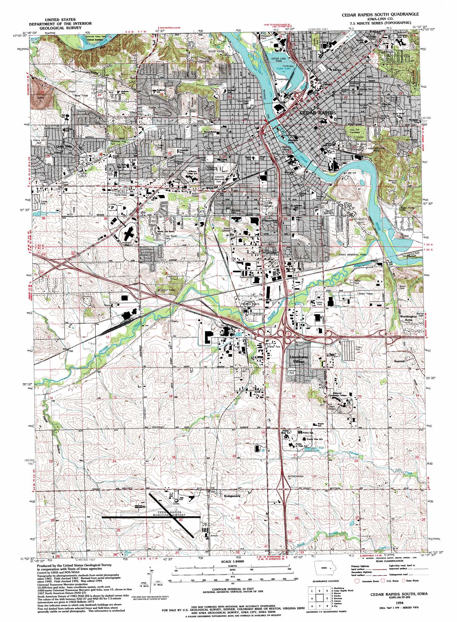
Cedar Rapids South Topo Map Iowa
To zoom in, hover over the map of Cedar Rapids South
USGS Topo Quad 41091h6 - 1:24,000 scale
| Topo Map Name: | Cedar Rapids South |
| USGS Topo Quad ID: | 41091h6 |
| Print Size: | ca. 21 1/4" wide x 27" high |
| Southeast Coordinates: | 41.875° N latitude / 91.625° W longitude |
| Map Center Coordinates: | 41.9375° N latitude / 91.6875° W longitude |
| U.S. State: | IA |
| Filename: | o41091h6.jpg |
| Download Map JPG Image: | Cedar Rapids South topo map 1:24,000 scale |
| Map Type: | Topographic |
| Topo Series: | 7.5´ |
| Map Scale: | 1:24,000 |
| Source of Map Images: | United States Geological Survey (USGS) |
| Alternate Map Versions: |
Cedar Rapids South IA 1967, updated 1969 Download PDF Buy paper map Cedar Rapids South IA 1967, updated 1976 Download PDF Buy paper map Cedar Rapids South IA 1967, updated 1983 Download PDF Buy paper map Cedar Rapids South IA 1994, updated 1994 Download PDF Buy paper map Cedar Rapids South IA 2010 Download PDF Buy paper map Cedar Rapids South IA 2013 Download PDF Buy paper map Cedar Rapids South IA 2015 Download PDF Buy paper map |
1:24,000 Topo Quads surrounding Cedar Rapids South
Center Point Nw |
Center Point |
Lafayette |
Central City |
Prairieburg |
Center Point Sw |
Shellsburg |
Cedar Rapids North |
Marion |
Springville |
Newhall |
Fairfax |
Cedar Rapids South |
Bertram |
Mount Vernon |
Middle Amana |
Amana |
Swisher |
Ely |
Solon |
Conroy |
Oxford |
Tiffin |
Iowa City West |
Iowa City East |
> Back to 41091e1 at 1:100,000 scale
> Back to 41090a1 at 1:250,000 scale
> Back to U.S. Topo Maps home
Cedar Rapids South topo map: Gazetteer
Cedar Rapids South: Airports
Cedar Rapids Emergency Heliport elevation 240m 787′Cedar Rapids Municipal Airport elevation 260m 853′
Faltis Airport elevation 243m 797′
Mays Island Helistop elevation 217m 711′
Mercy Hospital Heliport elevation 225m 738′
Saint Lukes Hospital Emergency Heliport elevation 231m 757′
Cedar Rapids South: Bridges
First Avenue Bridge elevation 213m 698′Cedar Rapids South: Crossings
Interchange 13 elevation 256m 839′Interchange 16 elevation 225m 738′
Interchange 17 elevation 244m 800′
Interchange 18 elevation 241m 790′
Interchange 19A elevation 230m 754′
Interchange 19B elevation 220m 721′
Interchange 19C elevation 217m 711′
Interchange 20 elevation 230m 754′
Interchange 21 elevation 226m 741′
Cedar Rapids South: Islands
Municipal Island elevation 218m 715′Cedar Rapids South: Lakes
Cedar Lake elevation 220m 721′Cedar Rapids South: Mines
Cedar Rapids Quarry elevation 230m 754′Cedar Rapids South: Parks
Alandale Park elevation 236m 774′Anderson Park elevation 247m 810′
Apache Park elevation 235m 770′
Arrowhead Park elevation 265m 869′
Beaver Park elevation 256m 839′
Beverly Park elevation 251m 823′
Cedar Valley Park elevation 223m 731′
Cherokee Trail Park elevation 240m 787′
Cherry Hill Park elevation 257m 843′
Cheyenne Park elevation 241m 790′
Clark Field elevation 225m 738′
Cleveland Park elevation 242m 793′
Daniels Park elevation 234m 767′
Ellis Park elevation 235m 770′
Fairview Park elevation 241m 790′
First School House in Cedar Rapids Historical Marker elevation 225m 738′
Glenway Park elevation 246m 807′
Green Square Park elevation 223m 731′
Greene Park elevation 223m 731′
Hawkeye Downs Park elevation 221m 725′
Hayes Park elevation 221m 725′
Huston Park elevation 228m 748′
Iroquois Park elevation 246m 807′
Jackson Park elevation 257m 843′
Jacolyn Park elevation 246m 807′
Jay Park elevation 221m 725′
Jones Memorial Park elevation 216m 708′
Kingston Stadium elevation 235m 770′
Marble Fountain in Cedar Rapids Historical Marker elevation 235m 770′
Northview Park elevation 237m 777′
Osborn Park elevation 216m 708′
Plaza Park elevation 219m 718′
Prairie Creek Park elevation 219m 718′
Redmond Park elevation 227m 744′
Reed Park elevation 224m 734′
Riverfront Park elevation 213m 698′
Riverside Park elevation 222m 728′
Sac and Fox Indian Trail Park elevation 226m 741′
Shawnee Park elevation 238m 780′
Sinclair Park elevation 222m 728′
Stefan Park elevation 221m 725′
Tait Cummins Memorial Park elevation 219m 718′
Time-Check Park elevation 220m 721′
Tomahawk Park elevation 230m 754′
Van Buren Park elevation 238m 780′
Van Vechten Park elevation 227m 744′
Veterans Memorial Park elevation 229m 751′
Williams Park elevation 242m 793′
Cedar Rapids South: Populated Places
Beverly Depot elevation 231m 757′Cedar Hills elevation 259m 849′
East Rapids elevation 217m 711′
Grand View Village elevation 252m 826′
Hometown-Cedar Terrace elevation 254m 833′
Kirkwood Estates elevation 235m 770′
Konigsmark elevation 256m 839′
Lincolnway Village elevation 226m 741′
Perrys Rollin' Homes Manor elevation 224m 734′
Summit elevation 244m 800′
Summit View Mobile Home Park elevation 254m 833′
Sunrise Mobile Court elevation 223m 731′
West Cedar Rapids elevation 226m 741′
West Park Mobile Home Village elevation 253m 830′
Worthington Acres elevation 246m 807′
Cedar Rapids South: Post Offices
Cedar Rapids Post Office elevation 223m 731′Kingston City Post Office (historical) elevation 222m 728′
Cedar Rapids South: Streams
Cold Stream elevation 220m 721′Prairie Creek elevation 213m 698′
Willow Creek elevation 221m 725′
Cedar Rapids South: Valleys
Tissel Hollow elevation 224m 734′Cedar Rapids South digital topo map on disk
Buy this Cedar Rapids South topo map showing relief, roads, GPS coordinates and other geographical features, as a high-resolution digital map file on DVD: