Belle Plaine Topo Map Iowa
To zoom in, hover over the map of Belle Plaine
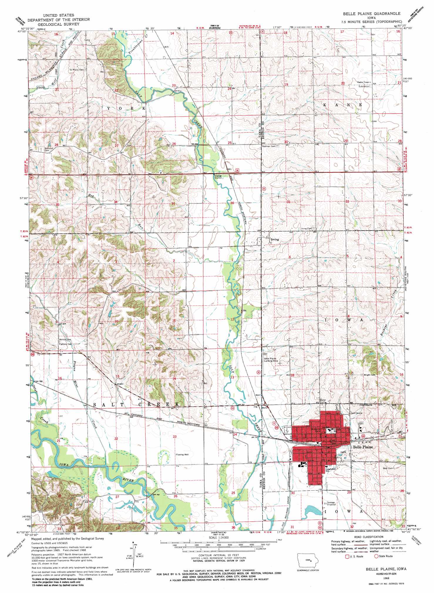
USGS Topo Quad 41092h3 - 1:24,000 scale
| Topo Map Name: | Belle Plaine |
| USGS Topo Quad ID: | 41092h3 |
| Print Size: | ca. 21 1/4" wide x 27" high |
| Southeast Coordinates: | 41.875° N latitude / 92.25° W longitude |
| Map Center Coordinates: | 41.9375° N latitude / 92.3125° W longitude |
| U.S. State: | IA |
| Filename: | o41092h3.jpg |
| Download Map JPG Image: | Belle Plaine topo map 1:24,000 scale |
| Map Type: | Topographic |
| Topo Series: | 7.5´ |
| Map Scale: | 1:24,000 |
| Source of Map Images: | United States Geological Survey (USGS) |
| Alternate Map Versions: |
Belle Plaine IA 1968, updated 1970 Download PDF Buy paper map Belle Plaine IA 1968, updated 1986 Download PDF Buy paper map Belle Plaine IA 2010 Download PDF Buy paper map Belle Plaine IA 2013 Download PDF Buy paper map Belle Plaine IA 2015 Download PDF Buy paper map |
1:24,000 Topo Quads surrounding Belle Plaine
Gladbrook Ne |
Traer |
Dysart |
Garrison |
Vinton |
Gladbrook Se |
Clutier |
Elberon |
Keystone North |
Van Horne |
Tama |
Chelsea |
Belle Plaine |
Keystone South |
Blairstown |
Sheridan |
Belle Plaine Sw |
Hartwick |
Ladora |
Marengo |
Malcom |
Brooklyn |
Victor |
Williamsburg Nw |
Williamsburg |
> Back to 41092e1 at 1:100,000 scale
> Back to 41092a1 at 1:250,000 scale
> Back to U.S. Topo Maps home
Belle Plaine topo map: Gazetteer
Belle Plaine: Airports
Belle Plaine Municipal Airport elevation 233m 764′Belle Plaine: Bridges
Chambers Ford Bridge elevation 233m 764′Belle Plaine: Dams
Camp Arrowhead Lake Dam elevation 278m 912′Belle Plaine: Parks
Old Jumbo Well Historical Marker elevation 244m 800′Salt Creek Wildlife Area elevation 283m 928′
Site of Former Irving Historical Marker elevation 256m 839′
Williams Park elevation 258m 846′
Belle Plaine: Populated Places
Belle Plaine elevation 252m 826′Irving elevation 260m 853′
Redman (historical) elevation 260m 853′
Belle Plaine: Post Offices
Belle Plaine Post Office elevation 257m 843′Irving Post Office (historical) elevation 254m 833′
Redman Post Office (historical) elevation 260m 853′
Belle Plaine: Reservoirs
Camp Arrowhead Lake elevation 278m 912′Belle Plaine: Streams
Hog Run elevation 238m 780′Otter Creek elevation 235m 770′
Plague Mine Creek elevation 235m 770′
Belle Plaine digital topo map on disk
Buy this Belle Plaine topo map showing relief, roads, GPS coordinates and other geographical features, as a high-resolution digital map file on DVD: