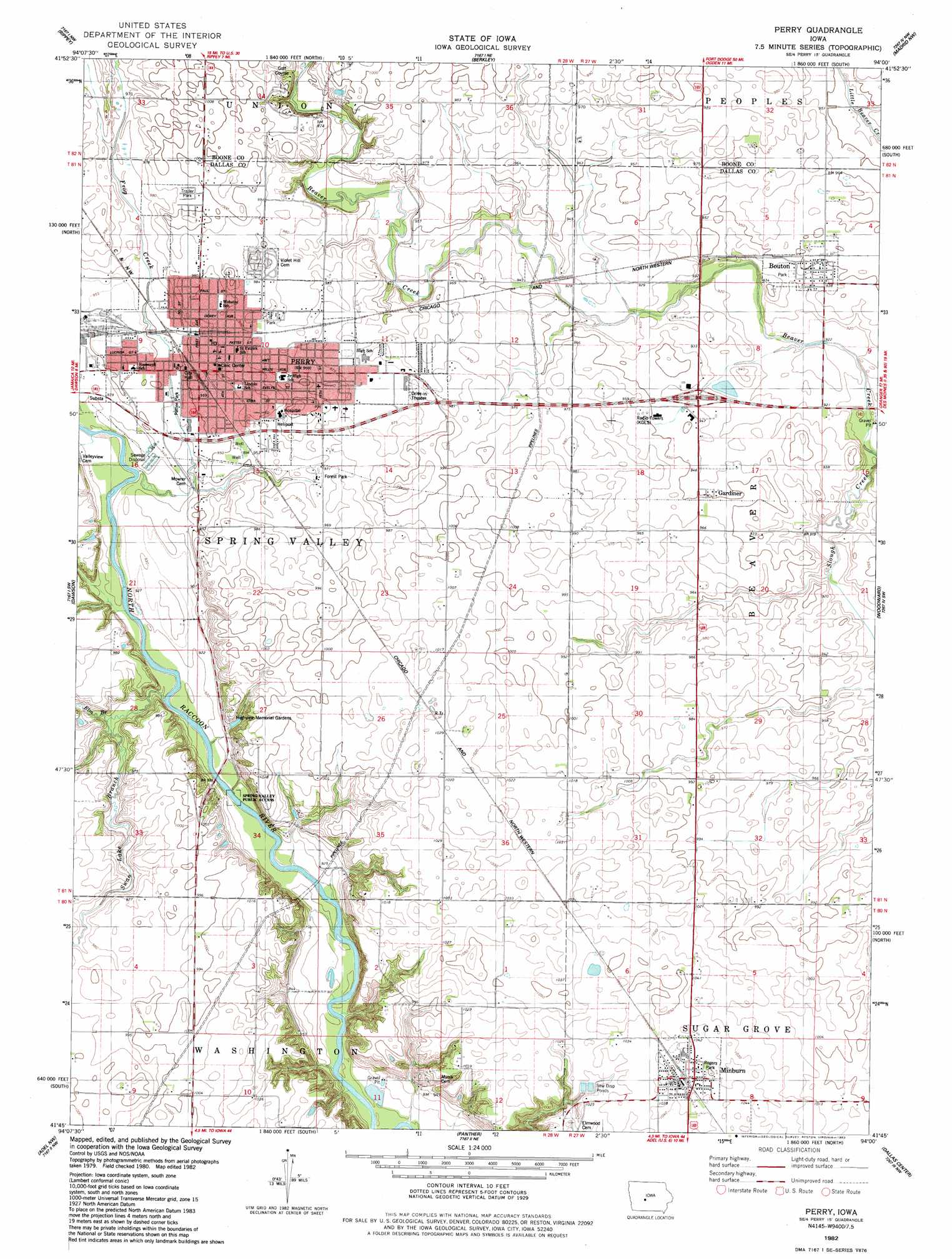
Perry Topo Map Iowa
To zoom in, hover over the map of Perry
USGS Topo Quad 41094g1 - 1:24,000 scale
| Topo Map Name: | Perry |
| USGS Topo Quad ID: | 41094g1 |
| Print Size: | ca. 21 1/4" wide x 27" high |
| Southeast Coordinates: | 41.75° N latitude / 94° W longitude |
| Map Center Coordinates: | 41.8125° N latitude / 94.0625° W longitude |
| U.S. State: | IA |
| Filename: | o41094g1.jpg |
| Download Map JPG Image: | Perry topo map 1:24,000 scale |
| Map Type: | Topographic |
| Topo Series: | 7.5´ |
| Map Scale: | 1:24,000 |
| Source of Map Images: | United States Geological Survey (USGS) |
| Alternate Map Versions: |
Perry IA 1982, updated 1983 Download PDF Buy paper map Perry IA 2010 Download PDF Buy paper map Perry IA 2013 Download PDF Buy paper map Perry IA 2015 Download PDF Buy paper map |
1:24,000 Topo Quads surrounding Perry
Jefferson East |
Grand Junction |
Ogden |
Boone West |
Boone East |
Cooper |
Rippey |
Berkley |
Madrid Nw |
Luther |
Yale |
Dawson |
Perry |
Woodward |
Granger |
Panora |
Adel Nw |
Panther |
Dallas Center |
Grimes |
Stuart North |
Redfield |
Adel |
Waukee |
Commerce |
> Back to 41094e1 at 1:100,000 scale
> Back to 41094a1 at 1:250,000 scale
> Back to U.S. Topo Maps home
Perry topo map: Gazetteer
Perry: Bridges
Beaver Creek Bridge elevation 281m 921′Graney Bridge elevation 279m 915′
Perry: Parks
Caboose Park elevation 293m 961′Pattee Park elevation 287m 941′
Perkins Park elevation 291m 954′
Rogers Park elevation 318m 1043′
Voas Nature Area elevation 314m 1030′
Wiese Park elevation 300m 984′
Perry: Populated Places
Bar-Jac Mobile Estates elevation 303m 994′Bouton elevation 288m 944′
Gardiner elevation 290m 951′
Minburn elevation 319m 1046′
Perry elevation 293m 961′
Perry Yard elevation 299m 980′
Perry: Post Offices
Bouton Post Office elevation 288m 944′Gardiner Post Office (historical) elevation 290m 951′
Minburn Post Office elevation 317m 1040′
Perry Post Office elevation 295m 967′
Perry: Streams
Elm Branch elevation 277m 908′Frog Creek elevation 280m 918′
Slough Creek elevation 275m 902′
Swan Lake Branch elevation 279m 915′
Perry digital topo map on disk
Buy this Perry topo map showing relief, roads, GPS coordinates and other geographical features, as a high-resolution digital map file on DVD: