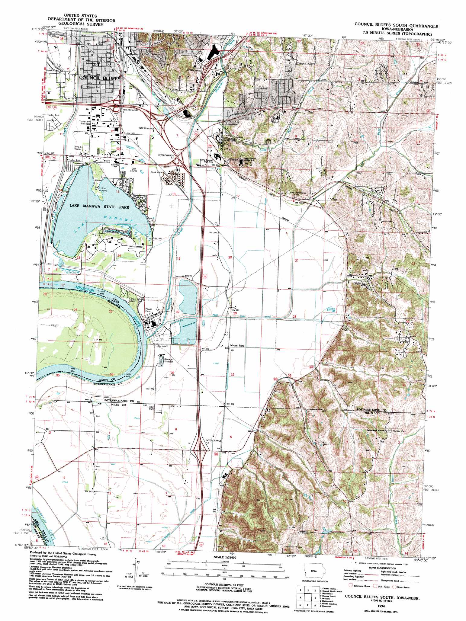
Council Bluffs South Topo Map Iowa
To zoom in, hover over the map of Council Bluffs South
USGS Topo Quad 41095b7 - 1:24,000 scale
| Topo Map Name: | Council Bluffs South |
| USGS Topo Quad ID: | 41095b7 |
| Print Size: | ca. 21 1/4" wide x 27" high |
| Southeast Coordinates: | 41.125° N latitude / 95.75° W longitude |
| Map Center Coordinates: | 41.1875° N latitude / 95.8125° W longitude |
| U.S. States: | IA, NE |
| Filename: | o41095b7.jpg |
| Download Map JPG Image: | Council Bluffs South topo map 1:24,000 scale |
| Map Type: | Topographic |
| Topo Series: | 7.5´ |
| Map Scale: | 1:24,000 |
| Source of Map Images: | United States Geological Survey (USGS) |
| Alternate Map Versions: |
Council Bluffs South IA 1956, updated 1958 Download PDF Buy paper map Council Bluffs South IA 1956, updated 1970 Download PDF Buy paper map Council Bluffs South IA 1956, updated 1977 Download PDF Buy paper map Council Bluffs South IA 1994, updated 1994 Download PDF Buy paper map Council Bluffs South IA 2010 Download PDF Buy paper map Council Bluffs South IA 2013 Download PDF Buy paper map Council Bluffs South IA 2015 Download PDF Buy paper map |
1:24,000 Topo Quads surrounding Council Bluffs South
Fort Calhoun |
Loveland |
Honey Creek |
Underwood |
Neola |
Irvington |
Omaha North |
Council Bluffs North |
Mcclelland |
Taylor |
Ralston |
Omaha South |
Council Bluffs South |
Mineola |
Treynor |
Cedar Creek |
Plattsmouth |
Pacific Junction |
Glenwood |
Malvern |
Weeping Water Ne |
Murray |
Rock Bluff |
Tabor |
Tabor Ne |
> Back to 41095a1 at 1:100,000 scale
> Back to 41094a1 at 1:250,000 scale
> Back to U.S. Topo Maps home
Council Bluffs South topo map: Gazetteer
Council Bluffs South: Bends
Manawa Bend elevation 290m 951′Manawa Bend elevation 290m 951′
Council Bluffs South: Canals
Indian Creek Ditch elevation 295m 967′Saint Marys Ditch elevation 293m 961′
Council Bluffs South: Crossings
Interchange 3 elevation 299m 980′Interchange 4 elevation 302m 990′
Interchange 42 elevation 298m 977′
Interchange 47 elevation 299m 980′
Interchange 48 elevation 302m 990′
Interchange 5 elevation 308m 1010′
Council Bluffs South: Lakes
Lake Manawa elevation 293m 961′Council Bluffs South: Parks
Grand Encampment Marker elevation 303m 994′Iowa West Foundation Trailhead Park elevation 301m 987′
Lake Manawa State Park elevation 293m 961′
Longs Landing County Park elevation 294m 964′
Manawa City Park elevation 296m 971′
Mormon Battalion Marker elevation 303m 994′
North Shore Park elevation 296m 971′
Peterson Park elevation 299m 980′
Sunset Park elevation 299m 980′
Tree Lake Park elevation 368m 1207′
Council Bluffs South: Populated Places
Bluff Acres Mobile Home Park elevation 297m 974′Country Estates Mobile Home Park elevation 298m 977′
Regency of Iowa Mobile Home Park elevation 297m 974′
Wooded Lake Mobile Home Park elevation 298m 977′
Council Bluffs South: Post Offices
Islandpark Post Office (historical) elevation 295m 967′Lake Manawa Post Office (historical) elevation 296m 971′
Neoga Post Office (historical) elevation 311m 1020′
Council Bluffs South: Reservoirs
Tree Lake elevation 368m 1207′Council Bluffs South: Streams
Indian Creek elevation 293m 961′Mosquito Creek elevation 290m 951′
Council Bluffs South: Trails
Iowa School of the Deaf Nature Center Trail elevation 303m 994′Council Bluffs South digital topo map on disk
Buy this Council Bluffs South topo map showing relief, roads, GPS coordinates and other geographical features, as a high-resolution digital map file on DVD: