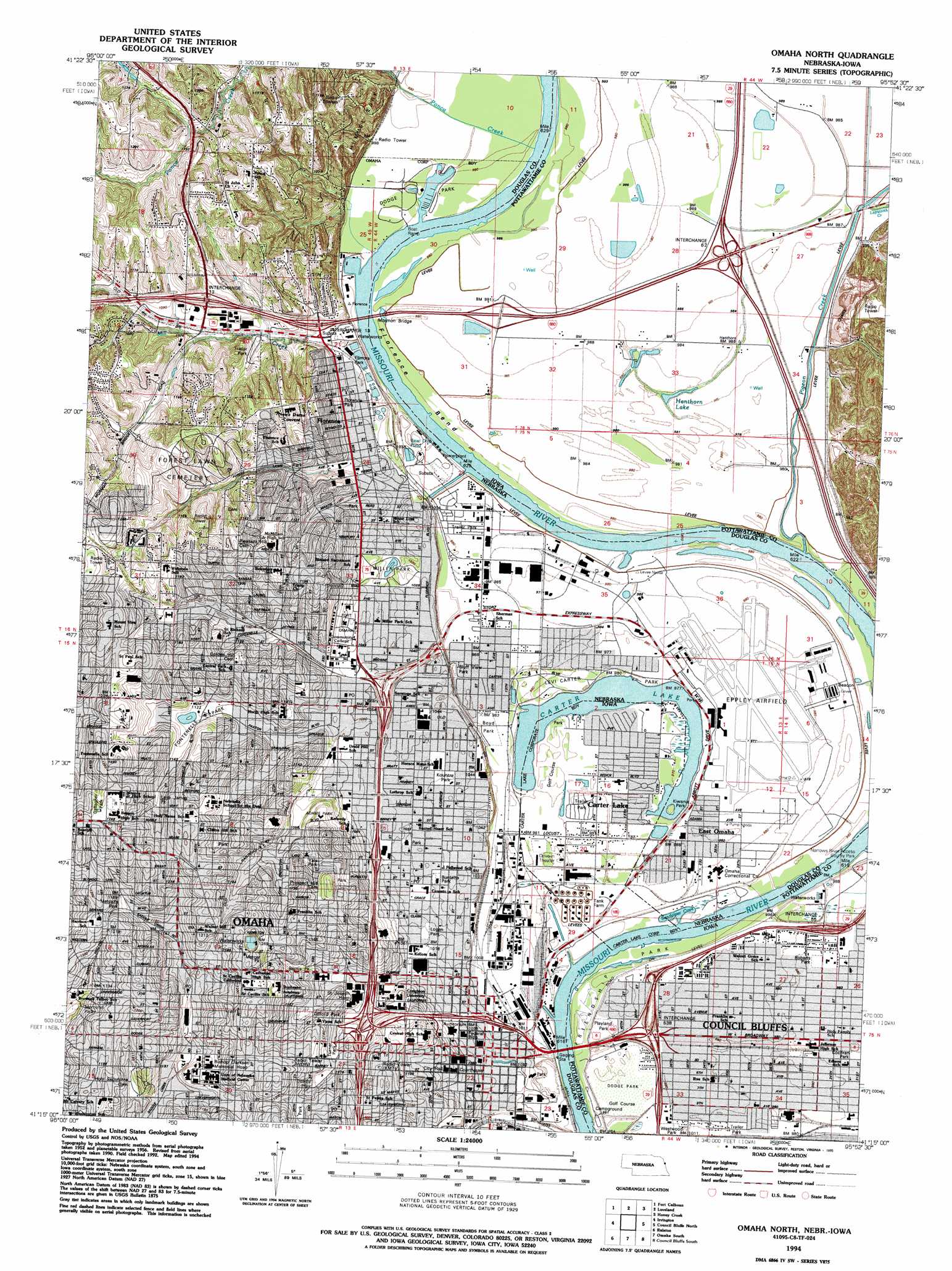
Omaha North Topo Map Nebraska
To zoom in, hover over the map of Omaha North
USGS Topo Quad 41095c8 - 1:24,000 scale
| Topo Map Name: | Omaha North |
| USGS Topo Quad ID: | 41095c8 |
| Print Size: | ca. 21 1/4" wide x 27" high |
| Southeast Coordinates: | 41.25° N latitude / 95.875° W longitude |
| Map Center Coordinates: | 41.3125° N latitude / 95.9375° W longitude |
| U.S. States: | NE, IA |
| Filename: | O41095C8.jpg |
| Download Map JPG Image: | Omaha North topo map 1:24,000 scale |
| Map Type: | Topographic |
| Topo Series: | 7.5´ |
| Map Scale: | 1:24,000 |
| Source of Map Images: | United States Geological Survey (USGS) |
| Alternate Map Versions: |
Omaha North NE 1956, updated 1958 Download PDF Buy paper map Omaha North NE 1956, updated 1970 Download PDF Buy paper map Omaha North NE 1956, updated 1977 Download PDF Buy paper map Omaha North NE 1956, updated 1984 Download PDF Buy paper map Omaha North NE 1956, updated 1989 Download PDF Buy paper map Omaha North NE 1994, updated 1995 Download PDF Buy paper map Omaha North NE 2011 Download PDF Buy paper map Omaha North NE 2014 Download PDF Buy paper map |
1:24,000 Topo Quads surrounding Omaha North
Blair |
Modale |
Missouri Valley |
Beebeetown |
Hard Scratch |
Kennard |
Fort Calhoun |
Loveland |
Honey Creek |
Underwood |
Elkhorn |
Irvington |
Omaha North |
Council Bluffs North |
Mcclelland |
Gretna |
Ralston |
Omaha South |
Council Bluffs South |
Mineola |
Springfield |
Cedar Creek |
Plattsmouth |
Pacific Junction |
Glenwood |
> Back to 41095a1 at 1:100,000 scale
> Back to 41094a1 at 1:250,000 scale
> Back to U.S. Topo Maps home
Omaha North topo map: Gazetteer
Omaha North: Airports
Eppley Airfield elevation 298m 977′Saint Joseph Hospital Heliport elevation 336m 1102′
University of Nebraska Medical Center Heliport elevation 351m 1151′
Omaha North: Bays
Sandpiper Cove elevation 298m 977′Omaha North: Bends
Council Bend elevation 293m 961′Council Bend elevation 293m 961′
Florence Bend elevation 296m 971′
Florence Bend elevation 296m 971′
Omaha North: Bridges
Ak Sar Ben Bridge elevation 293m 961′Mormon Bridge elevation 296m 971′
Omaha North: Channels
The Narrows elevation 297m 974′The Narrows elevation 297m 974′
Omaha North: Crossings
Interchange 1 elevation 302m 990′Interchange 12 elevation 334m 1095′
Interchange 13 elevation 310m 1017′
Interchange 1B elevation 352m 1154′
Interchange 1C elevation 343m 1125′
Interchange 2A elevation 325m 1066′
Interchange 2B elevation 325m 1066′
Interchange 2C elevation 325m 1066′
Interchange 2D elevation 325m 1066′
Interchange 3 elevation 305m 1000′
Interchange 4 elevation 308m 1010′
Interchange 53A elevation 299m 980′
Interchange 53B elevation 304m 997′
Interchange 54A elevation 297m 974′
Interchange 54B elevation 299m 980′
Interchange 55 elevation 309m 1013′
Interchange 62 elevation 302m 990′
Omaha North: Lakes
Carter Lake elevation 296m 971′Carter Lake elevation 294m 964′
Hanthorn Lake elevation 299m 980′
Omaha North: Levees
Council Bluffs Levee Unit elevation 299m 980′Omaha Levee Unit elevation 298m 977′
Omaha North: Mines
Crescent Quarry elevation 324m 1062′Omaha North: Parks
Adams Park elevation 349m 1145′Bank of Florence Historical Marker elevation 324m 1062′
Bedford Place Park elevation 317m 1040′
Bemis Park elevation 345m 1131′
Bluff View Park elevation 299m 980′
Burdette Park elevation 312m 1023′
Capitol Hill Historical Marker elevation 348m 1141′
Central High School Historical Marker elevation 348m 1141′
Central Park Mall elevation 316m 1036′
Cochran Park elevation 299m 980′
Colonial Acres Park elevation 350m 1148′
Creighton University Historical Marker elevation 329m 1079′
Crook House Historical Marker elevation 335m 1099′
Crown Point Park elevation 355m 1164′
Dewey Park elevation 340m 1115′
Dodge Park elevation 299m 980′
Dodge Park elevation 299m 980′
Duchesne Academy Historical Marker elevation 366m 1200′
Erskine Park elevation 342m 1122′
Filmore Park elevation 316m 1036′
Florence Mill Historical Marker elevation 305m 1000′
Florence Park elevation 323m 1059′
Fontenelle Park elevation 340m 1115′
Forest Lawn Memorial Park Historical Marker elevation 330m 1082′
Fort Omaha Historical Marker elevation 321m 1053′
Freedom Park elevation 300m 984′
Friendship Park elevation 299m 980′
Gallagher Park elevation 384m 1259′
Gene Leahy Mall elevation 314m 1030′
Gifford Park elevation 337m 1105′
Golden Spike Monument elevation 299m 980′
Graham Triangle Park elevation 317m 1040′
Heartland of America Park elevation 299m 980′
Himebaugh Park elevation 314m 1030′
Historic Prospect Hill - Omahas Pioneer Cemetery Historical Marker elevation 365m 1197′
Hoummel Park elevation 367m 1204′
Kellom Greenbelt Park elevation 309m 1013′
Kellom Park elevation 315m 1033′
Kenefick Park elevation 302m 990′
Kountze Park elevation 314m 1030′
Lake James Park elevation 357m 1171′
Leavenworth Park elevation 352m 1154′
Levi Carter Park elevation 298m 977′
Lewis and Clark Camp Site: July 27 1804 Historical Marker elevation 316m 1036′
Logan Park elevation 311m 1020′
Malcolm X Historical Marker elevation 341m 1118′
Memorial Park elevation 334m 1095′
Mercer Park elevation 366m 1200′
Metcalfe Park elevation 359m 1177′
Miami Playground elevation 359m 1177′
Miller Park elevation 311m 1020′
Myott Park elevation 345m 1131′
Narrows River Access County Park elevation 299m 980′
Park East elevation 350m 1148′
Pershing Park elevation 299m 980′
Playland Park elevation 299m 980′
Roberts Park elevation 302m 990′
Spaulding Park elevation 320m 1049′
Thirty-Second and Franklin Street Park elevation 355m 1164′
Trans-Mississippi and Inter Expo Historical Marker elevation 299m 980′
Turner Park elevation 342m 1122′
Twenty-Eighth and Craig Street Park elevation 315m 1033′
Twenty-Second and Willis Street Park elevation 314m 1030′
Walnut Hill Park elevation 379m 1243′
Westwood Park elevation 300m 984′
William Henry Jackson Historical Marker elevation 317m 1040′
Winter Quarters Historical Marker elevation 325m 1066′
Yale Park elevation 347m 1138′
Omaha North: Populated Places
Beechwood elevation 301m 987′Carter Lake elevation 299m 980′
Clara elevation 302m 990′
East Omaha elevation 299m 980′
Garden Valley Courts elevation 301m 987′
Home Park elevation 301m 987′
Omaha elevation 323m 1059′
Overland Mobile Home Park elevation 301m 987′
Ponderosa Village Mobile Home Park elevation 301m 987′
Town and Country Mobile Homes elevation 320m 1049′
Omaha North: Post Offices
A Station elevation 311m 1020′Ames Avenue Post Office Station elevation 322m 1056′
B Station elevation 366m 1200′
Florence Post Office Station elevation 319m 1046′
Omaha Downtown Post Office Station elevation 316m 1036′
Saddle Creek Post Office Station elevation 340m 1115′
Omaha North: Streams
Lapworth Creek elevation 301m 987′Mill Creek elevation 304m 997′
Pigeon Creek elevation 293m 961′
Ponca Creek elevation 299m 980′
Omaha North digital topo map on disk
Buy this Omaha North topo map showing relief, roads, GPS coordinates and other geographical features, as a high-resolution digital map file on DVD: