Dow City Topo Map Iowa
To zoom in, hover over the map of Dow City
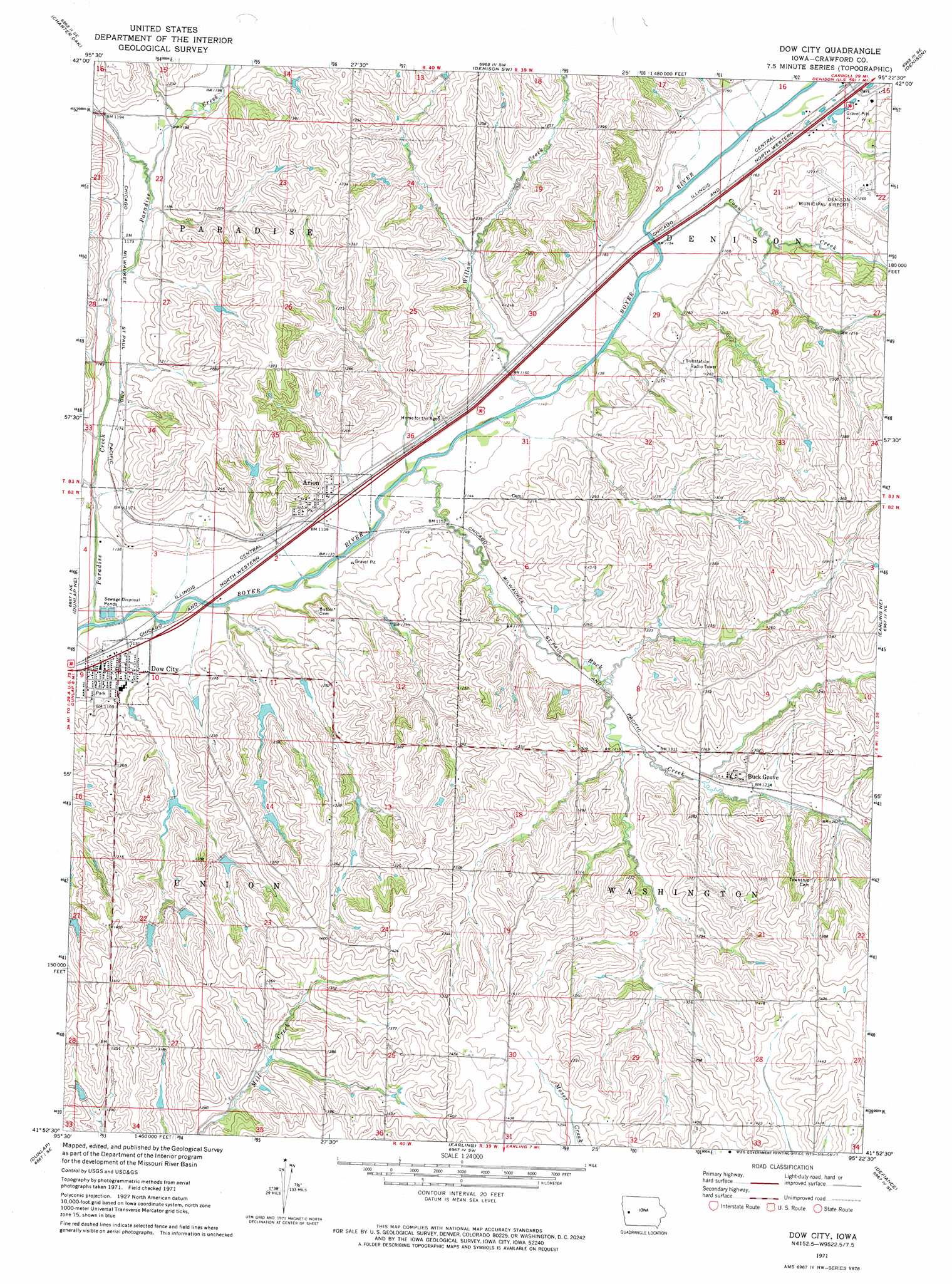
USGS Topo Quad 41095h4 - 1:24,000 scale
| Topo Map Name: | Dow City |
| USGS Topo Quad ID: | 41095h4 |
| Print Size: | ca. 21 1/4" wide x 27" high |
| Southeast Coordinates: | 41.875° N latitude / 95.375° W longitude |
| Map Center Coordinates: | 41.9375° N latitude / 95.4375° W longitude |
| U.S. State: | IA |
| Filename: | o41095h4.jpg |
| Download Map JPG Image: | Dow City topo map 1:24,000 scale |
| Map Type: | Topographic |
| Topo Series: | 7.5´ |
| Map Scale: | 1:24,000 |
| Source of Map Images: | United States Geological Survey (USGS) |
| Alternate Map Versions: |
Dow City IA 1971, updated 1973 Download PDF Buy paper map Dow City IA 2010 Download PDF Buy paper map Dow City IA 2013 Download PDF Buy paper map Dow City IA 2015 Download PDF Buy paper map |
1:24,000 Topo Quads surrounding Dow City
Danbury |
Ricketts |
Schleswig |
Kiron |
Boyer |
Ute |
Charter Oak |
Denison Sw |
Denison |
Vail |
Dunlap Nw |
Dunlap Ne |
Dow City |
Earling Ne |
Manilla |
Dunlap Sw |
Dunlap |
Earling |
Defiance |
Irwin |
Woodbine |
Portsmouth |
Panama |
Harlan |
Jacksonville |
> Back to 41095e1 at 1:100,000 scale
> Back to 41094a1 at 1:250,000 scale
> Back to U.S. Topo Maps home
Dow City topo map: Gazetteer
Dow City: Airports
Denison Municipal Airport elevation 386m 1266′Dow City: Bridges
Buck Grove Bridge elevation 379m 1243′Dow City: Parks
County Farm Park elevation 359m 1177′Dow City: Populated Places
Arion elevation 351m 1151′Bell elevation 350m 1148′
Buck Grove elevation 385m 1263′
Dow City elevation 348m 1141′
Kimze elevation 355m 1164′
Dow City: Post Offices
Arion Post Office elevation 350m 1148′Bell Post Office (historical) elevation 350m 1148′
Buck Grove Post Office (historical) elevation 390m 1279′
Dow City Post Office elevation 346m 1135′
Dow City: Streams
Buck Creek elevation 341m 1118′Coon Creek elevation 348m 1141′
Paradise Creek elevation 341m 1118′
Willow Creek elevation 343m 1125′
Dow City digital topo map on disk
Buy this Dow City topo map showing relief, roads, GPS coordinates and other geographical features, as a high-resolution digital map file on DVD: