Ashland East Topo Map Nebraska
To zoom in, hover over the map of Ashland East
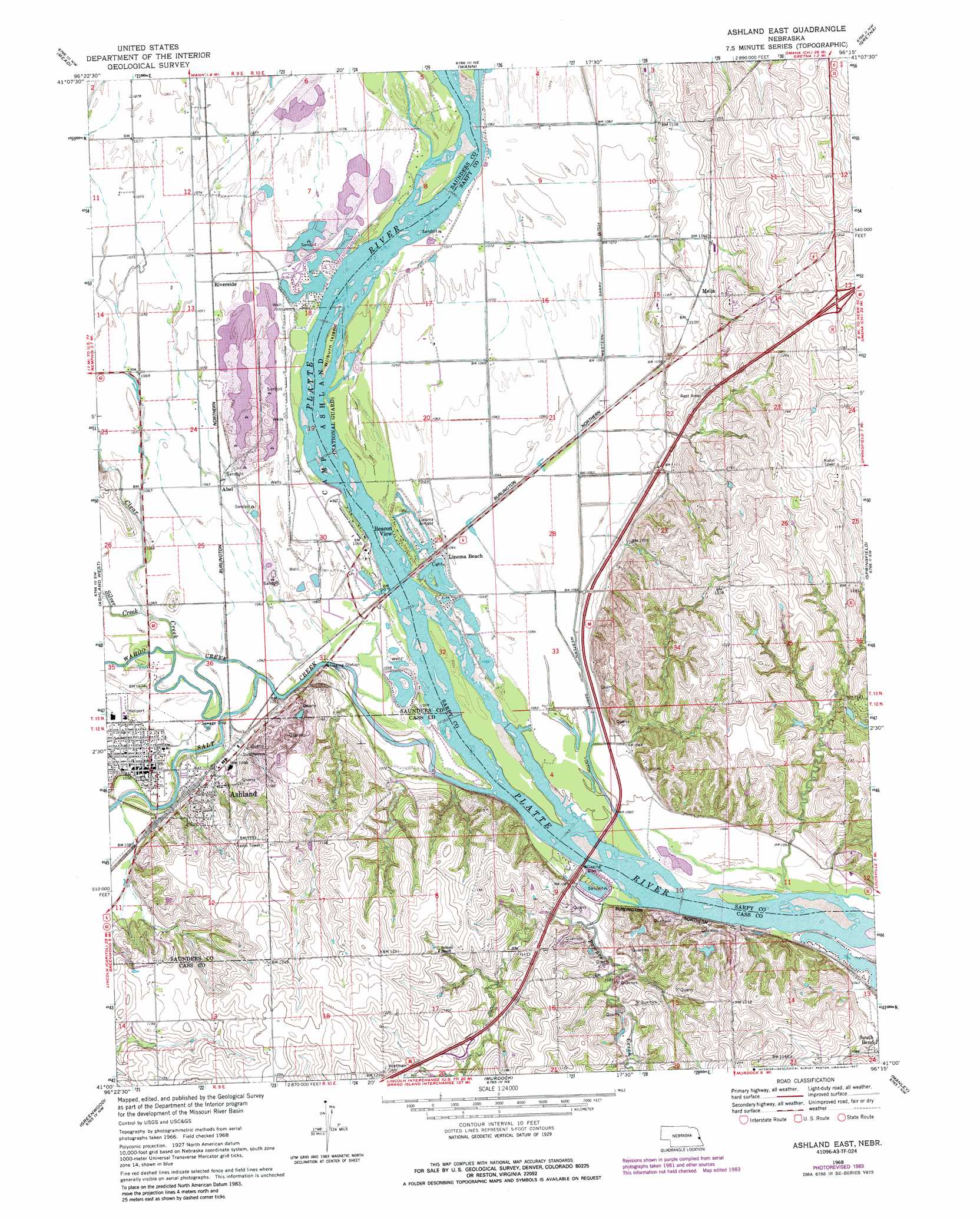
USGS Topo Quad 41096a3 - 1:24,000 scale
| Topo Map Name: | Ashland East |
| USGS Topo Quad ID: | 41096a3 |
| Print Size: | ca. 21 1/4" wide x 27" high |
| Southeast Coordinates: | 41° N latitude / 96.25° W longitude |
| Map Center Coordinates: | 41.0625° N latitude / 96.3125° W longitude |
| U.S. State: | NE |
| Filename: | O41096A3.jpg |
| Download Map JPG Image: | Ashland East topo map 1:24,000 scale |
| Map Type: | Topographic |
| Topo Series: | 7.5´ |
| Map Scale: | 1:24,000 |
| Source of Map Images: | United States Geological Survey (USGS) |
| Alternate Map Versions: |
Ashland East NE 1968, updated 1970 Download PDF Buy paper map Ashland East NE 1968, updated 1973 Download PDF Buy paper map Ashland East NE 1968, updated 1983 Download PDF Buy paper map Ashland East NE 1968, updated 1987 Download PDF Buy paper map Ashland East NE 2011 Download PDF Buy paper map Ashland East NE 2014 Download PDF Buy paper map |
1:24,000 Topo Quads surrounding Ashland East
Colon |
Leshara |
Valley |
Elkhorn |
Irvington |
Wahoo East |
Mead |
Wann |
Gretna |
Ralston |
Wahoo Se |
Ashland West |
Ashland East |
Springfield |
Cedar Creek |
Waverly |
Greenwood |
Murdock |
Manley |
Weeping Water Ne |
Walton |
Eagle |
Elmwood |
Weeping Water |
Avoca |
> Back to 41096a1 at 1:100,000 scale
> Back to 41096a1 at 1:250,000 scale
> Back to U.S. Topo Maps home
Ashland East topo map: Gazetteer
Ashland East: Airports
HJ Paul Army Heliport elevation 323m 1059′Koke Airport elevation 370m 1213′
Ashland East: Canals
Western Sarpy Ditch elevation 323m 1059′Ashland East: Crossings
Interchange 426 elevation 347m 1138′Interchange 432 elevation 387m 1269′
Ashland East: Dams
Armbrust Dam elevation 339m 1112′Philpot Dam elevation 335m 1099′
Ashland East: Islands
Wilburn Island elevation 323m 1059′Ashland East: Parks
Eugene T Mahoney State Park elevation 363m 1190′Great Platte Valley Historical Marker elevation 361m 1184′
Gretna Fish Hatchery Historical Marker elevation 339m 1112′
Memorial to the American Bandshell Sculpture elevation 355m 1164′
Ox-Bow Trail Historical Marker elevation 332m 1089′
Prehistorical Burial Site Historical Marker elevation 352m 1154′
Schramm Park State Recreational Area elevation 336m 1102′
Wildlife Safari elevation 352m 1154′
Ashland East: Populated Places
Abel elevation 326m 1069′Ashland elevation 332m 1089′
Beacon View elevation 323m 1059′
Iron Horse elevation 358m 1174′
Linoma Beach elevation 323m 1059′
Melia elevation 345m 1131′
Riverside elevation 328m 1076′
Ashland East: Post Offices
Ashland Post Office elevation 334m 1095′Melia Post Office (historical) elevation 345m 1131′
Ashland East: Reservoirs
Big Sandy Lake elevation 329m 1079′Philpot Reservoir elevation 335m 1099′
Thousand Oaks Lake elevation 339m 1112′
US West Lake elevation 338m 1108′
Ashland East: Streams
Clear Creek elevation 326m 1069′Elkhorn River elevation 326m 1069′
Pawnee Creek elevation 317m 1040′
Salt Creek elevation 317m 1040′
Wahoo Creek elevation 323m 1059′
Ashland East: Trails
E T Mahoney Trails elevation 363m 1190′Schramm Park National Recreation Trail elevation 336m 1102′
Ashland East digital topo map on disk
Buy this Ashland East topo map showing relief, roads, GPS coordinates and other geographical features, as a high-resolution digital map file on DVD: