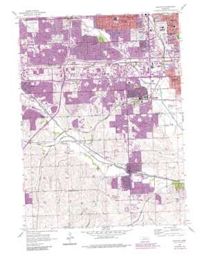
Ralston Topo Map Nebraska
To zoom in, hover over the map of Ralston
USGS Topo Quad 41096b1 - 1:24,000 scale
| Topo Map Name: | Ralston |
| USGS Topo Quad ID: | 41096b1 |
| Print Size: | ca. 21 1/4" wide x 27" high |
| Southeast Coordinates: | 41.125° N latitude / 96° W longitude |
| Map Center Coordinates: | 41.1875° N latitude / 96.0625° W longitude |
| U.S. State: | NE |
| Filename: | O41096B1.jpg |
| Download Map JPG Image: | Ralston topo map 1:24,000 scale |
| Map Type: | Topographic |
| Topo Series: | 7.5´ |
| Map Scale: | 1:24,000 |
| Source of Map Images: | United States Geological Survey (USGS) |
| Alternate Map Versions: |
Ralston NE 1956, updated 1957 Download PDF Buy paper map Ralston NE 1956, updated 1970 Download PDF Buy paper map Ralston NE 1956, updated 1977 Download PDF Buy paper map Ralston NE 1956, updated 1984 Download PDF Buy paper map Ralston NE 1956, updated 1984 Download PDF Buy paper map Ralston NE 2011 Download PDF Buy paper map Ralston NE 2014 Download PDF Buy paper map |
1:24,000 Topo Quads surrounding Ralston
> Back to 41096a1 at 1:100,000 scale
> Back to 41096a1 at 1:250,000 scale
> Back to U.S. Topo Maps home
Ralston topo map: Gazetteer
Ralston: Airports
Bergan Mercy Hospital Heliport elevation 348m 1141′Millard Airport elevation 317m 1040′
South Omaha Airport (historical) elevation 321m 1053′
Ralston: Crossings
Interchange 1 elevation 329m 1079′Interchange 2 elevation 335m 1099′
Interchange 443 elevation 315m 1033′
Interchange 445 elevation 339m 1112′
Interchange 446 elevation 347m 1138′
Interchange 448 elevation 309m 1013′
Interchange 449 elevation 332m 1089′
Interchange 450 elevation 335m 1099′
Ralston: Parks
Ak Sar Ben Field elevation 314m 1030′Ak-Sar-Ben Field and the US Air Mail Historical Marker elevation 332m 1089′
Apollo Park elevation 315m 1033′
Applewood Heights elevation 343m 1125′
Armbrust Park elevation 320m 1049′
Bay Meadows Park elevation 337m 1105′
Brookside Park elevation 321m 1053′
Camenzind Park elevation 357m 1171′
Cancer Survivors Park elevation 312m 1023′
Central Park elevation 323m 1059′
Champion Park elevation 316m 1036′
Citidal Park elevation 350m 1148′
Cody Park elevation 350m 1148′
Conoco Park elevation 309m 1013′
Eberle-Walden Park elevation 322m 1056′
Fun Plex elevation 305m 1000′
Garden Park elevation 317m 1040′
Halleck Park elevation 313m 1026′
Happy Hollow Park elevation 311m 1020′
Hickory Hills Park elevation 323m 1059′
Hollis Park elevation 340m 1115′
Jaycee Park elevation 349m 1145′
Karen Park elevation 308m 1010′
Kelly McMahon Field elevation 344m 1128′
Kingswood Park elevation 369m 1210′
La Vista City Park elevation 349m 1145′
La Vista Sports Complex elevation 305m 1000′
Lawrence Peterson Park elevation 306m 1003′
Mayor Park elevation 316m 1036′
Millard Heights Park elevation 315m 1033′
Mockingbird Heights Park elevation 336m 1102′
Mockingbird Hill Park elevation 320m 1049′
Monarch Park elevation 315m 1033′
Montclair - Westwood Park elevation 362m 1187′
Montclair Park elevation 376m 1233′
Municipal Park elevation 314m 1030′
Oak Heights Park elevation 329m 1079′
Oak Park elevation 324m 1062′
Oaks Park elevation 342m 1122′
Omaha Historical Marker elevation 313m 1026′
One Pacific Place Park elevation 312m 1023′
Orval Smith Park elevation 327m 1072′
Overland Hills Park elevation 337m 1105′
Papillion City Park elevation 308m 1010′
Pipal Park elevation 352m 1154′
Prairie Lane Park elevation 338m 1108′
Rockbrook Park elevation 325m 1066′
Rockglenn Park elevation 350m 1148′
Roxbury Park elevation 337m 1105′
Sandoz Park elevation 318m 1043′
Schwer Recreational Area elevation 333m 1092′
Seventh Street Park elevation 336m 1102′
Signal Hill Park elevation 355m 1164′
Tara Hills Park elevation 329m 1079′
Timber Creek Park elevation 322m 1056′
Towl Park elevation 322m 1056′
Trendwood Park elevation 360m 1181′
Trumble Park elevation 324m 1062′
Vista Childrens Memorial Park elevation 343m 1125′
Walnut Creek Recreation Area elevation 330m 1082′
Westwood Heights Park elevation 344m 1128′
Wildewood Park elevation 320m 1049′
Young Park elevation 316m 1036′
Ralston: Populated Places
Aksarben Mobile Home Park elevation 311m 1020′Caradon Mobile Home Park elevation 330m 1082′
Coniglias Mobile Home Park elevation 309m 1013′
La Vista elevation 338m 1108′
Millard elevation 326m 1069′
Papillion elevation 308m 1010′
Portal elevation 314m 1030′
Ralston elevation 349m 1145′
Ralston: Post Offices
Deerfield Post Office (historical) elevation 307m 1007′Millard Highlands Post Office Branch elevation 339m 1112′
Millard Post Office (historical) elevation 326m 1069′
Papillion Post Office elevation 332m 1089′
Portal Post Office (historical) elevation 314m 1030′
Ralston Post Office elevation 313m 1026′
Stoney Ridge Post Office Station elevation 339m 1112′
West Omaha Post Office Station elevation 319m 1046′
Ralston: Reservoirs
Shadow Lake elevation 329m 1079′Walnut Creek Lake elevation 317m 1040′
Ralston: Streams
Applewood Creek elevation 305m 1000′Blood Creek elevation 300m 984′
Cemetery Creek elevation 318m 1043′
East Midland Creek elevation 314m 1030′
Elmwood Creek elevation 308m 1010′
F Street Drain elevation 303m 994′
Frederick Street Drain elevation 305m 1000′
Hell Creek elevation 306m 1003′
La Vista Creek elevation 302m 990′
Little Papillion Creek elevation 306m 1003′
Midland Creek elevation 298m 977′
Mockingbird Creek elevation 304m 997′
Ralston Creek elevation 299m 980′
Rockbrook Creek elevation 306m 1003′
Saddle Creek elevation 306m 1003′
Savanna Creek elevation 325m 1066′
Schram Creek elevation 303m 994′
South Papillion Creek elevation 308m 1010′
Thompson Creek elevation 299m 980′
Walnut Creek elevation 303m 994′
West Midland Creek elevation 317m 1040′
West Papillion Creek elevation 306m 1003′
Westmont Creek elevation 308m 1010′
Ralston: Trails
Big Papio Trail elevation 309m 1013′Halleck Park Trail elevation 309m 1013′
Keystone Trail elevation 302m 990′
Ralston digital topo map on disk
Buy this Ralston topo map showing relief, roads, GPS coordinates and other geographical features, as a high-resolution digital map file on DVD:


