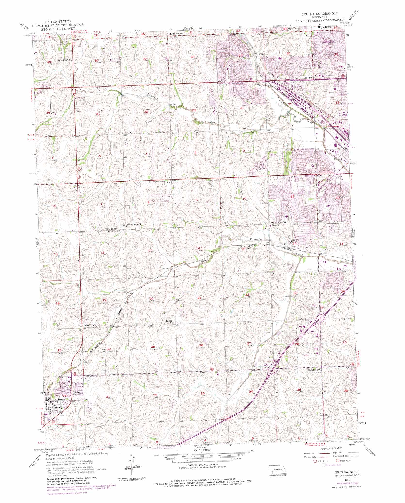
Gretna Topo Map Nebraska
To zoom in, hover over the map of Gretna
USGS Topo Quad 41096b2 - 1:24,000 scale
| Topo Map Name: | Gretna |
| USGS Topo Quad ID: | 41096b2 |
| Print Size: | ca. 21 1/4" wide x 27" high |
| Southeast Coordinates: | 41.125° N latitude / 96.125° W longitude |
| Map Center Coordinates: | 41.1875° N latitude / 96.1875° W longitude |
| U.S. State: | NE |
| Filename: | O41096B2.jpg |
| Download Map JPG Image: | Gretna topo map 1:24,000 scale |
| Map Type: | Topographic |
| Topo Series: | 7.5´ |
| Map Scale: | 1:24,000 |
| Source of Map Images: | United States Geological Survey (USGS) |
| Alternate Map Versions: |
Gretna NE 1956, updated 1957 Download PDF Buy paper map Gretna NE 1956, updated 1967 Download PDF Buy paper map Gretna NE 1956, updated 1970 Download PDF Buy paper map Gretna NE 1956, updated 1975 Download PDF Buy paper map Gretna NE 1956, updated 1977 Download PDF Buy paper map Gretna NE 1956, updated 1984 Download PDF Buy paper map Gretna NE 2011 Download PDF Buy paper map Gretna NE 2014 Download PDF Buy paper map |
1:24,000 Topo Quads surrounding Gretna
Fremont East |
Arlington |
Kennard |
Fort Calhoun |
Loveland |
Leshara |
Valley |
Elkhorn |
Irvington |
Omaha North |
Mead |
Wann |
Gretna |
Ralston |
Omaha South |
Ashland West |
Ashland East |
Springfield |
Cedar Creek |
Plattsmouth |
Greenwood |
Murdock |
Manley |
Weeping Water Ne |
Murray |
> Back to 41096a1 at 1:100,000 scale
> Back to 41096a1 at 1:250,000 scale
> Back to U.S. Topo Maps home
Gretna topo map: Gazetteer
Gretna: Airports
Willowood Airport elevation 367m 1204′Gretna: Crossings
Interchange 439 elevation 351m 1151′Interchange 440 elevation 364m 1194′
Gretna: Dams
Papillion Creek Dam D-38 elevation 342m 1122′Wiebe Dam elevation 355m 1164′
Gretna: Parks
Anderson Field elevation 321m 1053′Center Park elevation 343m 1125′
Chalco Hills Recreation Area elevation 329m 1079′
Cottonwood Park elevation 339m 1112′
Discovery Soccer Complex elevation 322m 1056′
Ed Zorinsky Recreation Area elevation 337m 1105′
Englewood Park elevation 326m 1069′
Gretna City Park elevation 391m 1282′
Harvey Oaks Park elevation 334m 1095′
Kingswood Park elevation 352m 1154′
Leo Royal Memorial Park elevation 387m 1269′
Millard Highlands Park elevation 357m 1171′
Parkside Park elevation 373m 1223′
Peterson Park elevation 388m 1272′
Walnut Grove Park elevation 368m 1207′
Westchester Park elevation 320m 1049′
Gretna: Populated Places
Chalco elevation 327m 1072′Gretna elevation 387m 1269′
Lane elevation 332m 1089′
Millard Mobile Home Park elevation 322m 1056′
Skyline elevation 391m 1282′
Gretna: Post Offices
Chalco Post Office (historical) elevation 327m 1072′Gretna Post Office elevation 387m 1269′
Gretna: Reservoirs
Papillion Creek Reservoir D-38 elevation 342m 1122′Wehrspann Lake elevation 330m 1082′
Wiebe Reservoir elevation 355m 1164′
Zorinsky Lake elevation 339m 1112′
Gretna: Streams
Beadle Creek elevation 333m 1092′Boxelder Creek elevation 320m 1049′
Crystal Creek elevation 344m 1128′
Mission Creek elevation 324m 1062′
Morton Creek elevation 324m 1062′
North Boxelder Creek elevation 350m 1148′
North Wehrspann Creek elevation 318m 1043′
Oak View Creek elevation 318m 1043′
Pacific Hollow Creek elevation 326m 1069′
South Wehrspann Creek elevation 341m 1118′
Tiburon Creek elevation 330m 1082′
Wehrspann Creek elevation 318m 1043′
Whitehawk Creek elevation 343m 1125′
Gretna: Trails
Chalco Hills Trails elevation 326m 1069′Millard Highway Fifty Trail elevation 316m 1036′
West Papio Trail elevation 329m 1079′
Zorinsky Park Trail elevation 346m 1135′
Gretna digital topo map on disk
Buy this Gretna topo map showing relief, roads, GPS coordinates and other geographical features, as a high-resolution digital map file on DVD: