Valley Topo Map Nebraska
To zoom in, hover over the map of Valley
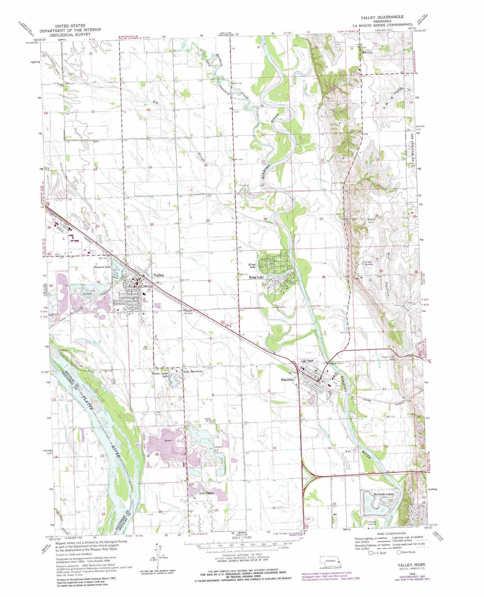
USGS Topo Quad 41096c3 - 1:24,000 scale
| Topo Map Name: | Valley |
| USGS Topo Quad ID: | 41096c3 |
| Print Size: | ca. 21 1/4" wide x 27" high |
| Southeast Coordinates: | 41.25° N latitude / 96.25° W longitude |
| Map Center Coordinates: | 41.3125° N latitude / 96.3125° W longitude |
| U.S. State: | NE |
| Filename: | O41096C3.jpg |
| Download Map JPG Image: | Valley topo map 1:24,000 scale |
| Map Type: | Topographic |
| Topo Series: | 7.5´ |
| Map Scale: | 1:24,000 |
| Source of Map Images: | United States Geological Survey (USGS) |
| Alternate Map Versions: |
Valley NE 1968, updated 1970 Download PDF Buy paper map Valley NE 1968, updated 1972 Download PDF Buy paper map Valley NE 1968, updated 1983 Download PDF Buy paper map Valley NE 2011 Download PDF Buy paper map Valley NE 2014 Download PDF Buy paper map |
1:24,000 Topo Quads surrounding Valley
Hooper |
Nickerson |
Orum |
Blair |
Modale |
Fremont West |
Fremont East |
Arlington |
Kennard |
Fort Calhoun |
Colon |
Leshara |
Valley |
Elkhorn |
Irvington |
Wahoo East |
Mead |
Wann |
Gretna |
Ralston |
Wahoo Se |
Ashland West |
Ashland East |
Springfield |
Cedar Creek |
> Back to 41096a1 at 1:100,000 scale
> Back to 41096a1 at 1:250,000 scale
> Back to U.S. Topo Maps home
Valley topo map: Gazetteer
Valley: Airports
Rogert Airstrip elevation 345m 1131′Valley Fire and Rescue Department and Civil Defense Heliport elevation 348m 1141′
Valley: Lakes
Kings Lake elevation 344m 1128′Lake Clagus elevation 341m 1118′
Lake Taormina elevation 343m 1125′
Pleasure Lake elevation 346m 1135′
Riverside Lakes elevation 336m 1102′
Timber Lodge Lake elevation 343m 1125′
Valley: Populated Places
C and K Mobile Home Park elevation 347m 1138′Elk City elevation 398m 1305′
King Lake elevation 344m 1128′
Valley elevation 348m 1141′
Waterloo elevation 344m 1128′
Valley: Post Offices
Elk City Post Office (historical) elevation 398m 1305′Primrose Post Office (historical) elevation 342m 1122′
Valley Post Office elevation 348m 1141′
Waterloo Post Office elevation 343m 1125′
Valley: Streams
Big Slough elevation 341m 1118′Rawhide Creek elevation 345m 1131′
Valley digital topo map on disk
Buy this Valley topo map showing relief, roads, GPS coordinates and other geographical features, as a high-resolution digital map file on DVD: