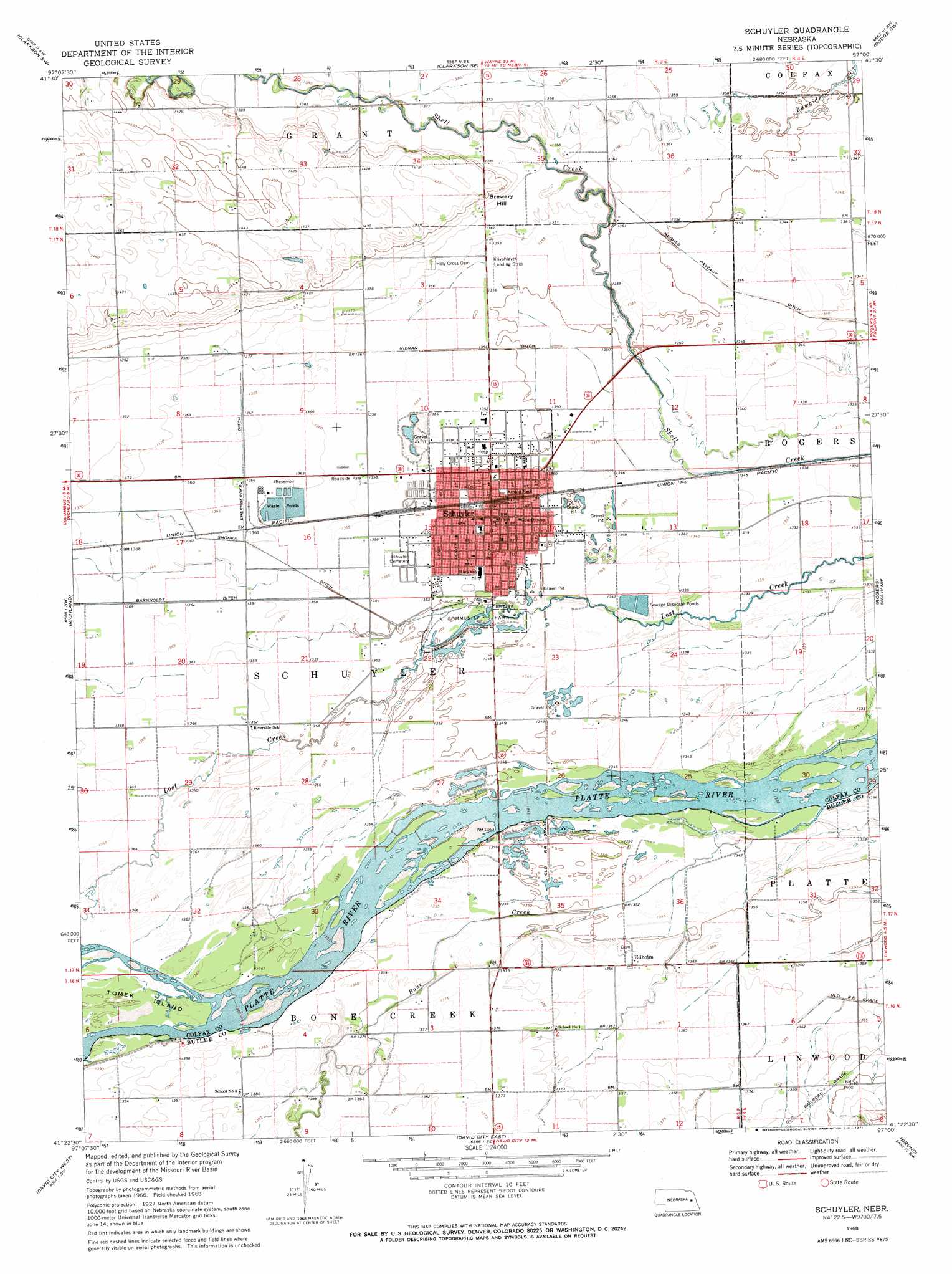
Schuyler Topo Map Nebraska
To zoom in, hover over the map of Schuyler
USGS Topo Quad 41097d1 - 1:24,000 scale
| Topo Map Name: | Schuyler |
| USGS Topo Quad ID: | 41097d1 |
| Print Size: | ca. 21 1/4" wide x 27" high |
| Southeast Coordinates: | 41.375° N latitude / 97° W longitude |
| Map Center Coordinates: | 41.4375° N latitude / 97.0625° W longitude |
| U.S. State: | NE |
| Filename: | O41097D1.jpg |
| Download Map JPG Image: | Schuyler topo map 1:24,000 scale |
| Map Type: | Topographic |
| Topo Series: | 7.5´ |
| Map Scale: | 1:24,000 |
| Source of Map Images: | United States Geological Survey (USGS) |
| Alternate Map Versions: |
Schuyler NE 1968, updated 1971 Download PDF Buy paper map Schuyler NE 2011 Download PDF Buy paper map Schuyler NE 2014 Download PDF Buy paper map |
1:24,000 Topo Quads surrounding Schuyler
Creston |
Leigh |
Clarkson |
Dodge |
Snyder |
Humphrey Se |
Clarkson Sw |
Clarkson Se |
Dodge Sw |
Webster |
Columbus |
Richland |
Schuyler |
Rogers |
North Bend |
Columbus Se |
David City West |
David City East |
Bruno |
Prague |
Rising City |
Garrison |
Brainard |
Loma |
Touhy |
> Back to 41097a1 at 1:100,000 scale
> Back to 41096a1 at 1:250,000 scale
> Back to U.S. Topo Maps home
Schuyler topo map: Gazetteer
Schuyler: Canals
Hughes Payzant Ditch elevation 408m 1338′Nieman Ditch elevation 412m 1351′
Schuyler: Lakes
Schuyler City Lake elevation 411m 1348′Schuyler: Parks
Arnold Park elevation 411m 1348′Community Park elevation 410m 1345′
Merchants Park elevation 412m 1351′
North Park elevation 412m 1351′
Schuyler Park elevation 411m 1348′
South Park elevation 409m 1341′
Whitetail State Wildlife Management Area elevation 414m 1358′
Schuyler: Populated Places
Edholm elevation 416m 1364′Genes Trailer Court elevation 412m 1351′
Lonnies Trailer Court elevation 413m 1354′
Schuyler elevation 412m 1351′
Sunset Acres elevation 414m 1358′
Schuyler: Post Offices
Edholm Post Office (historical) elevation 416m 1364′Schuyler Post Office elevation 412m 1351′
Schuyler: Streams
Bone Creek elevation 407m 1335′Schuyler: Summits
Brewery Hill elevation 430m 1410′Schuyler digital topo map on disk
Buy this Schuyler topo map showing relief, roads, GPS coordinates and other geographical features, as a high-resolution digital map file on DVD: