Roten Valley South Topo Map Nebraska
To zoom in, hover over the map of Roten Valley South
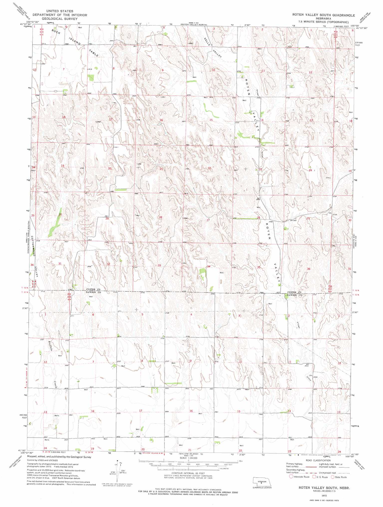
USGS Topo Quad 41100a1 - 1:24,000 scale
| Topo Map Name: | Roten Valley South |
| USGS Topo Quad ID: | 41100a1 |
| Print Size: | ca. 21 1/4" wide x 27" high |
| Southeast Coordinates: | 41° N latitude / 100° W longitude |
| Map Center Coordinates: | 41.0625° N latitude / 100.0625° W longitude |
| U.S. State: | NE |
| Filename: | O41100a1.jpg |
| Download Map JPG Image: | Roten Valley South topo map 1:24,000 scale |
| Map Type: | Topographic |
| Topo Series: | 7.5´ |
| Map Scale: | 1:24,000 |
| Source of Map Images: | United States Geological Survey (USGS) |
| Alternate Map Versions: |
Roten Valley South NE 1972, updated 1975 Download PDF Buy paper map Roten Valley South NE 2011 Download PDF Buy paper map Roten Valley South NE 2014 Download PDF Buy paper map |
1:24,000 Topo Quads surrounding Roten Valley South
Kilmer Valley |
Arnold Sw |
Murphy Table |
Callaway |
Callaway Se |
Brady Ne |
Odencranze Table North |
Roten Valley North |
Oconto Nw |
Oconto |
Brady |
Odencranze Table South |
Roten Valley South |
Oconto Sw |
Oconto Se |
Jeffrey Reservoir Ne |
Gothenburg |
Willow Island |
Cozad Nw |
Buffalo |
Jeffrey Reservoir Se |
Gothenburg Sw |
Gothenburg Se |
Cozad |
Lexington West |
> Back to 41100a1 at 1:100,000 scale
> Back to 41100a1 at 1:250,000 scale
> Back to U.S. Topo Maps home
Roten Valley South topo map: Gazetteer
Roten Valley South: Canals
Stump Ditch elevation 818m 2683′Roten Valley South: Dams
Cyriacks Dam elevation 836m 2742′Feddersen Dam elevation 824m 2703′
Spring Creek Dam 18-A elevation 806m 2644′
Spring Creek Dam 19-B elevation 804m 2637′
Roten Valley South: Reservoirs
Cyriacks Reservoir elevation 836m 2742′Feddersen Reservoir elevation 824m 2703′
Spring Creek Reservoir 18-A elevation 806m 2644′
Spring Creek Reservoir 19-B elevation 804m 2637′
Roten Valley South: Valleys
Cottonwood Valley elevation 823m 2700′Roten Valley elevation 800m 2624′
Sells Valley elevation 834m 2736′
Roten Valley South digital topo map on disk
Buy this Roten Valley South topo map showing relief, roads, GPS coordinates and other geographical features, as a high-resolution digital map file on DVD: