Harrisburg Topo Map Nebraska
To zoom in, hover over the map of Harrisburg
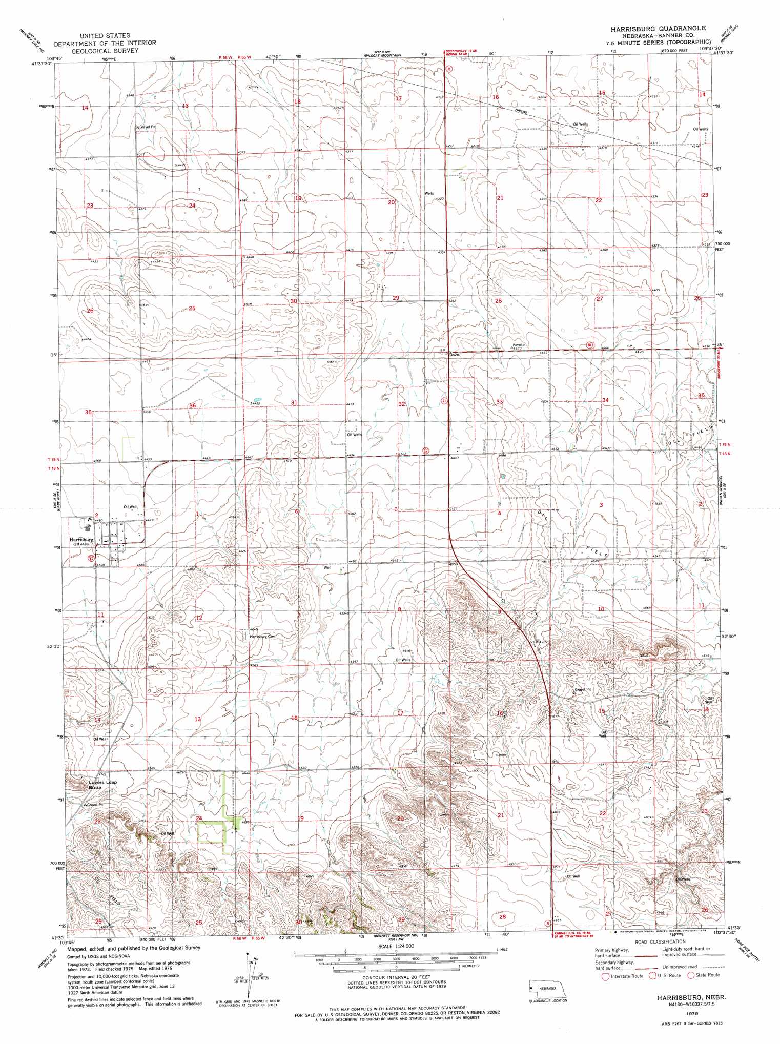
USGS Topo Quad 41103e6 - 1:24,000 scale
| Topo Map Name: | Harrisburg |
| USGS Topo Quad ID: | 41103e6 |
| Print Size: | ca. 21 1/4" wide x 27" high |
| Southeast Coordinates: | 41.5° N latitude / 103.625° W longitude |
| Map Center Coordinates: | 41.5625° N latitude / 103.6875° W longitude |
| U.S. State: | NE |
| Filename: | O41103E6.jpg |
| Download Map JPG Image: | Harrisburg topo map 1:24,000 scale |
| Map Type: | Topographic |
| Topo Series: | 7.5´ |
| Map Scale: | 1:24,000 |
| Source of Map Images: | United States Geological Survey (USGS) |
| Alternate Map Versions: |
Scotts Bluff 4 SW NE 1973, updated 1974 Download PDF Buy paper map Harrisburg NE 1979, updated 1979 Download PDF Buy paper map Harrisburg NE 2011 Download PDF Buy paper map Harrisburg NE 2014 Download PDF Buy paper map |
1:24,000 Topo Quads surrounding Harrisburg
Stegall |
Roubadeau Pass |
Scottsbluff South |
Minatare |
Bayard Sw |
Murray Lake |
Murray Lake Ne |
Wildcat Mountain |
Wright Gap |
Mcgrew |
Murray Lake Sw |
Gabe Rock |
Harrisburg |
Indian Springs |
Hackberry Creek |
Kimball 2 Nw |
Kimball 2 Ne |
Bennett Reservoir Nw |
Lone Pine Butte |
Singleton Ranch |
Kimball 2 Sw |
Kimball 2 Se |
Bennett Reservoir West |
Bennett Reservoir East |
Potter 2 Sw |
> Back to 41103e1 at 1:100,000 scale
> Back to 41102a1 at 1:250,000 scale
> Back to U.S. Topo Maps home
Harrisburg topo map: Gazetteer
Harrisburg: Dams
Downer Brothers Dam elevation 1402m 4599′Harrisburg: Populated Places
Harrisburg elevation 1369m 4491′Harrisburg: Post Offices
Harrisburg Post Office elevation 1369m 4491′Harrisburg: Reservoirs
Downer Brothers Reservoir elevation 1402m 4599′Harrisburg: Summits
Lovers Leap Butte elevation 1500m 4921′Harrisburg digital topo map on disk
Buy this Harrisburg topo map showing relief, roads, GPS coordinates and other geographical features, as a high-resolution digital map file on DVD:
Eastern Wyoming & Western South Dakota
Buy digital topo maps: Eastern Wyoming & Western South Dakota