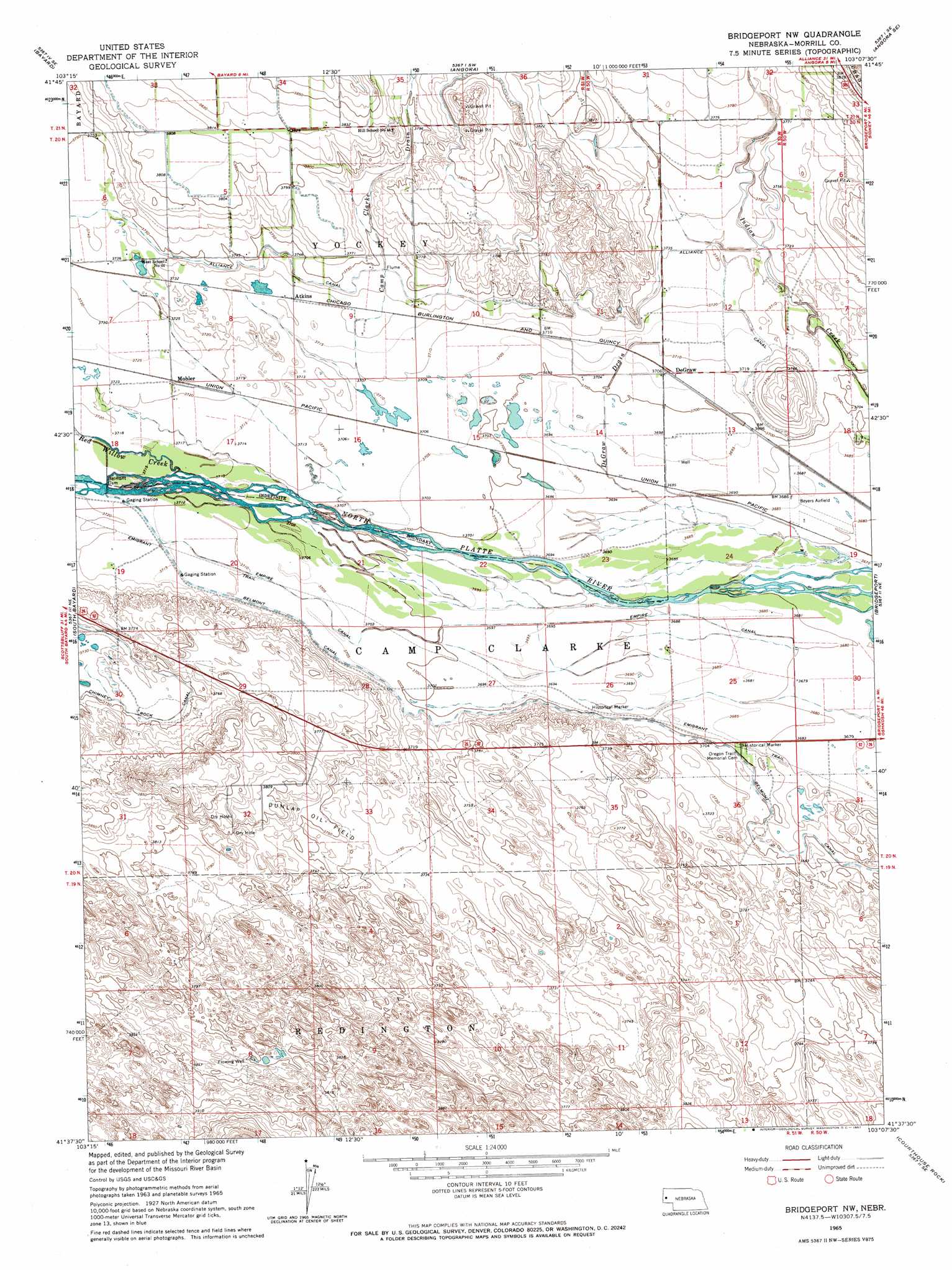
Bridgeport Nw Topo Map Nebraska
To zoom in, hover over the map of Bridgeport Nw
USGS Topo Quad 41103f2 - 1:24,000 scale
| Topo Map Name: | Bridgeport Nw |
| USGS Topo Quad ID: | 41103f2 |
| Print Size: | ca. 21 1/4" wide x 27" high |
| Southeast Coordinates: | 41.625° N latitude / 103.125° W longitude |
| Map Center Coordinates: | 41.6875° N latitude / 103.1875° W longitude |
| U.S. State: | NE |
| Filename: | O41103F2.jpg |
| Download Map JPG Image: | Bridgeport Nw topo map 1:24,000 scale |
| Map Type: | Topographic |
| Topo Series: | 7.5´ |
| Map Scale: | 1:24,000 |
| Source of Map Images: | United States Geological Survey (USGS) |
| Alternate Map Versions: |
Bridgeport NW NE 1965, updated 1967 Download PDF Buy paper map Bridgeport NW NE 2011 Download PDF Buy paper map Bridgeport NW NE 2014 Download PDF Buy paper map |
1:24,000 Topo Quads surrounding Bridgeport Nw
Lake Minatare |
Bayard Ne |
Angora Nw |
Angora Ne |
Cowboy Hill |
Bayard Sw |
Bayard |
Angora |
Angora Se |
Camp Lake |
Mcgrew |
South Bayard |
Bridgeport Nw |
Bridgeport |
Broadwater Nw |
Hackberry Creek |
Redington |
Roundhouse Rock |
Courthouse Rock |
Broadwater Sw |
Singleton Ranch |
Potter 2 Ne |
Horsehead Ranch |
Mud Springs |
Dalton |
> Back to 41103e1 at 1:100,000 scale
> Back to 41102a1 at 1:250,000 scale
> Back to U.S. Topo Maps home
Bridgeport Nw topo map: Gazetteer
Bridgeport Nw: Canals
Alliance Canal elevation 1142m 3746′Belmont Canal elevation 1128m 3700′
Empire Canal elevation 1127m 3697′
Bridgeport Nw: Dams
Belmont Dam elevation 1132m 3713′Belmont Diversion Dam elevation 1131m 3710′
Bridgeport Nw: Oilfields
Dunlap Oil Field elevation 1139m 3736′Bridgeport Nw: Parks
Camp Clarke Bridge and Sidney - Black Hills Trail Historical Marker elevation 1125m 3690′Bridgeport Nw: Populated Places
Atkins elevation 1134m 3720′DeGraw elevation 1131m 3710′
Mohler elevation 1135m 3723′
Bridgeport Nw: Reservoirs
Belmont Diversion Reservoir elevation 1131m 3710′Bridgeport Nw: Streams
Camp Clarke Drain elevation 1131m 3710′DeGraw Drain elevation 1122m 3681′
Red Willow Creek elevation 1131m 3710′
Bridgeport Nw digital topo map on disk
Buy this Bridgeport Nw topo map showing relief, roads, GPS coordinates and other geographical features, as a high-resolution digital map file on DVD:
Eastern Wyoming & Western South Dakota
Buy digital topo maps: Eastern Wyoming & Western South Dakota