Wildcat Mountain Topo Map Nebraska
To zoom in, hover over the map of Wildcat Mountain
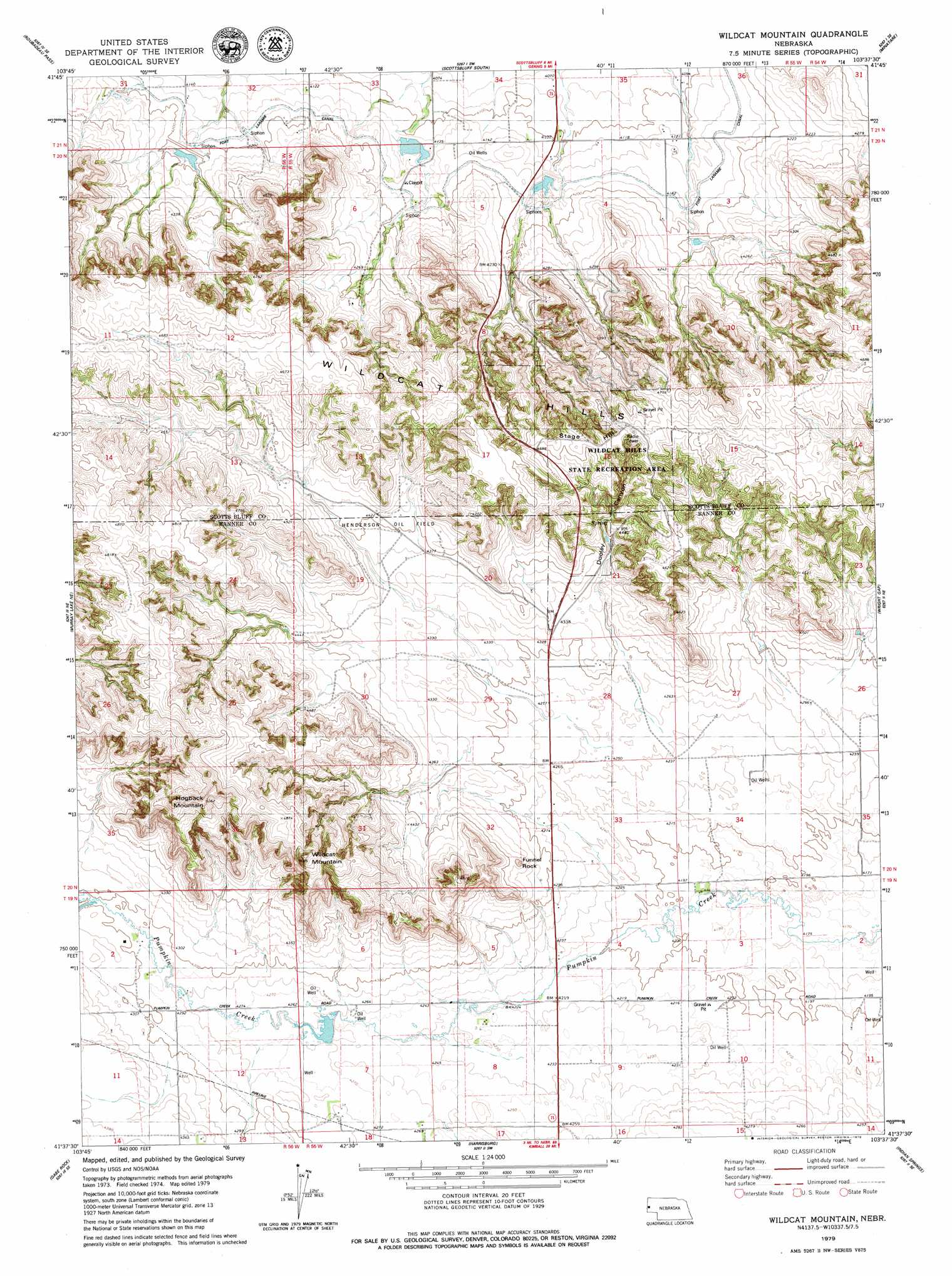
USGS Topo Quad 41103f6 - 1:24,000 scale
| Topo Map Name: | Wildcat Mountain |
| USGS Topo Quad ID: | 41103f6 |
| Print Size: | ca. 21 1/4" wide x 27" high |
| Southeast Coordinates: | 41.625° N latitude / 103.625° W longitude |
| Map Center Coordinates: | 41.6875° N latitude / 103.6875° W longitude |
| U.S. State: | NE |
| Filename: | O41103F6.jpg |
| Download Map JPG Image: | Wildcat Mountain topo map 1:24,000 scale |
| Map Type: | Topographic |
| Topo Series: | 7.5´ |
| Map Scale: | 1:24,000 |
| Source of Map Images: | United States Geological Survey (USGS) |
| Alternate Map Versions: |
Scotts Bluff 4 NW NE 1973, updated 1974 Download PDF Buy paper map Wildcat Mountain NE 1979, updated 1979 Download PDF Buy paper map Wildcat Mountain NE 2011 Download PDF Buy paper map Wildcat Mountain NE 2014 Download PDF Buy paper map |
1:24,000 Topo Quads surrounding Wildcat Mountain
Morrill |
Mitchell |
Scottsbluff North |
Lake Alice |
Lake Minatare |
Stegall |
Roubadeau Pass |
Scottsbluff South |
Minatare |
Bayard Sw |
Murray Lake |
Murray Lake Ne |
Wildcat Mountain |
Wright Gap |
Mcgrew |
Murray Lake Sw |
Gabe Rock |
Harrisburg |
Indian Springs |
Hackberry Creek |
Kimball 2 Nw |
Kimball 2 Ne |
Bennett Reservoir Nw |
Lone Pine Butte |
Singleton Ranch |
> Back to 41103e1 at 1:100,000 scale
> Back to 41102a1 at 1:250,000 scale
> Back to U.S. Topo Maps home
Wildcat Mountain topo map: Gazetteer
Wildcat Mountain: Dams
Airdale Dam Number 1 elevation 1271m 4169′Gering Valley Dam A elevation 1274m 4179′
Gering Valley Dam B elevation 1259m 4130′
Gering Valley Dam C elevation 1253m 4110′
Gering Valley Dam D elevation 1268m 4160′
Post Dam elevation 1322m 4337′
Scott Dam elevation 1299m 4261′
Wildcat Mountain: Oilfields
Henderson Oil Field elevation 1344m 4409′Wildcat Mountain: Parks
Wildcat Hills State Recreation Area elevation 1392m 4566′Wildcat Mountain: Pillars
Funnel Rock elevation 1348m 4422′Wildcat Mountain: Ranges
Wildcat Hills elevation 1421m 4662′Wildcat Mountain: Reservoirs
Airdale Reservoir Number 1 elevation 1271m 4169′Gering Valley Reservoir A elevation 1274m 4179′
Gering Valley Reservoir B elevation 1259m 4130′
Gering Valley Reservoir C elevation 1253m 4110′
Gering Valley Reservoir D elevation 1268m 4160′
Post Reservoir elevation 1322m 4337′
Scott Reservoir elevation 1299m 4261′
Wildcat Mountain: Summits
Hogback Mountain elevation 1545m 5068′Wildcat Mountain elevation 1404m 4606′
Wildcat Mountain: Trails
Wildcat Hills Trails elevation 1352m 4435′Wildcat Mountain: Valleys
Dooley Canyon elevation 1319m 4327′Wildcat Mountain digital topo map on disk
Buy this Wildcat Mountain topo map showing relief, roads, GPS coordinates and other geographical features, as a high-resolution digital map file on DVD:
Eastern Wyoming & Western South Dakota
Buy digital topo maps: Eastern Wyoming & Western South Dakota