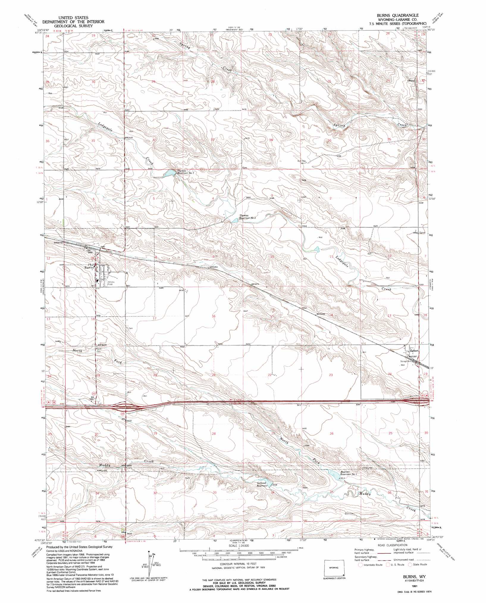
Burns Topo Map Wyoming
To zoom in, hover over the map of Burns
USGS Topo Quad 41104b3 - 1:24,000 scale
| Topo Map Name: | Burns |
| USGS Topo Quad ID: | 41104b3 |
| Print Size: | ca. 21 1/4" wide x 27" high |
| Southeast Coordinates: | 41.125° N latitude / 104.25° W longitude |
| Map Center Coordinates: | 41.1875° N latitude / 104.3125° W longitude |
| U.S. State: | WY |
| Filename: | o41104b3.jpg |
| Download Map JPG Image: | Burns topo map 1:24,000 scale |
| Map Type: | Topographic |
| Topo Series: | 7.5´ |
| Map Scale: | 1:24,000 |
| Source of Map Images: | United States Geological Survey (USGS) |
| Alternate Map Versions: |
Burns WY 1963, updated 1967 Download PDF Buy paper map Burns WY 1991, updated 1995 Download PDF Buy paper map Burns WY 2012 Download PDF Buy paper map Burns WY 2015 Download PDF Buy paper map |
1:24,000 Topo Quads surrounding Burns
Little Indian Draw |
Midway |
Round Top |
Gurney Peak |
Albin |
Pole Creek Ranch Se |
Midway Sw |
Midway Se |
Albin Sw |
Lindbergh |
Durham |
Hillsdale |
Burns |
Tracy |
Pine Bluffs |
Campstool |
Arcola |
Carpenter |
Pine Bluffs Sw |
Pine Bluffs Se |
Squaw Rock |
Hereford Nw |
Hereford |
Grover North |
Grover Ne |
> Back to 41104a1 at 1:100,000 scale
> Back to 41104a1 at 1:250,000 scale
> Back to U.S. Topo Maps home
Burns topo map: Gazetteer
Burns: Dams
C W Dam elevation 1658m 5439′Gilland Dam elevation 1630m 5347′
Thomas Number 2 Dam elevation 1653m 5423′
Burns: Mines
Kunau Pit elevation 1629m 5344′Burns: Populated Places
Burns elevation 1682m 5518′Egbert elevation 1613m 5291′
Burns: Reservoirs
Bastian Reservoir Number 1 elevation 1619m 5311′C W Reservoir elevation 1658m 5439′
Gilland Reservoir elevation 1629m 5344′
Gillard Reservoir elevation 1630m 5347′
Thomas Number 2 Reservoir elevation 1653m 5423′
Thomas Reservoir Number 1 elevation 1646m 5400′
Thomas Reservoir Number 2 elevation 1638m 5374′
Burns: Streams
North Fork Muddy Creek elevation 1614m 5295′Burns digital topo map on disk
Buy this Burns topo map showing relief, roads, GPS coordinates and other geographical features, as a high-resolution digital map file on DVD:
Eastern Wyoming & Western South Dakota
Buy digital topo maps: Eastern Wyoming & Western South Dakota