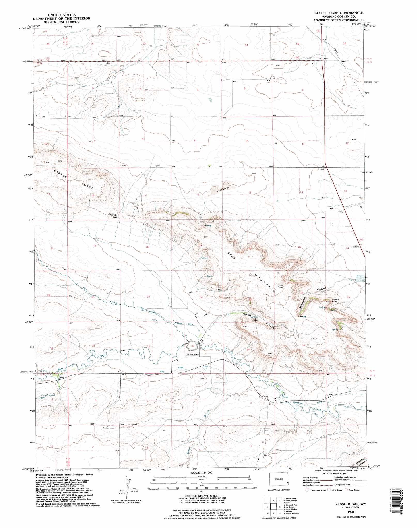
Kessler Gap Topo Map Wyoming
To zoom in, hover over the map of Kessler Gap
USGS Topo Quad 41104f3 - 1:24,000 scale
| Topo Map Name: | Kessler Gap |
| USGS Topo Quad ID: | 41104f3 |
| Print Size: | ca. 21 1/4" wide x 27" high |
| Southeast Coordinates: | 41.625° N latitude / 104.25° W longitude |
| Map Center Coordinates: | 41.6875° N latitude / 104.3125° W longitude |
| U.S. State: | WY |
| Filename: | o41104f3.jpg |
| Download Map JPG Image: | Kessler Gap topo map 1:24,000 scale |
| Map Type: | Topographic |
| Topo Series: | 7.5´ |
| Map Scale: | 1:24,000 |
| Source of Map Images: | United States Geological Survey (USGS) |
| Alternate Map Versions: |
Kessler Gap WY 1960, updated 1962 Download PDF Buy paper map Kessler Gap WY 1960, updated 1980 Download PDF Buy paper map Kessler Gap WY 1960, updated 1993 Download PDF Buy paper map Kessler Gap WY 1990, updated 1995 Download PDF Buy paper map Kessler Gap WY 2012 Download PDF Buy paper map Kessler Gap WY 2015 Download PDF Buy paper map |
1:24,000 Topo Quads surrounding Kessler Gap
Glomill Reservoir |
Veteran |
Yoder |
Huntley |
Lyman |
Y B O Ranch |
Needle Rock |
Hawk Springs |
Duroc |
Robb Draw |
Cattail Ranch Ne |
Diamond Flat |
Kessler Gap |
La Grange |
Mccompsey Pass |
Cattail Ranch |
Rocky Hollow |
Meriden |
Petsch Reservoir |
Tremain |
Little Indian Draw |
Midway |
Round Top |
Gurney Peak |
Albin |
> Back to 41104e1 at 1:100,000 scale
> Back to 41104a1 at 1:250,000 scale
> Back to U.S. Topo Maps home
Kessler Gap topo map: Gazetteer
Kessler Gap: Canals
Bear Creek Ditch elevation 1457m 4780′Kessler Ditch elevation 1440m 4724′
Lovercheck Ditch elevation 1419m 4655′
Kessler Gap: Dams
Babbitt Dam elevation 1474m 4835′Kessler Gap: Gaps
Kessler Gap elevation 1490m 4888′Kessler Gap: Reservoirs
Babbitt Reservoir elevation 1474m 4835′Kessler Gap: Streams
Badger Branch elevation 1421m 4662′Dater Creek elevation 1457m 4780′
Fox Creek elevation 1433m 4701′
Kessler Gap: Summits
Bear Mountain elevation 1621m 5318′Squaw Rock elevation 1526m 5006′
Kessler Gap: Valleys
Atterberry Canyon elevation 1391m 4563′Kessler Canyon elevation 1444m 4737′
Kessler Gap digital topo map on disk
Buy this Kessler Gap topo map showing relief, roads, GPS coordinates and other geographical features, as a high-resolution digital map file on DVD:
Eastern Wyoming & Western South Dakota
Buy digital topo maps: Eastern Wyoming & Western South Dakota