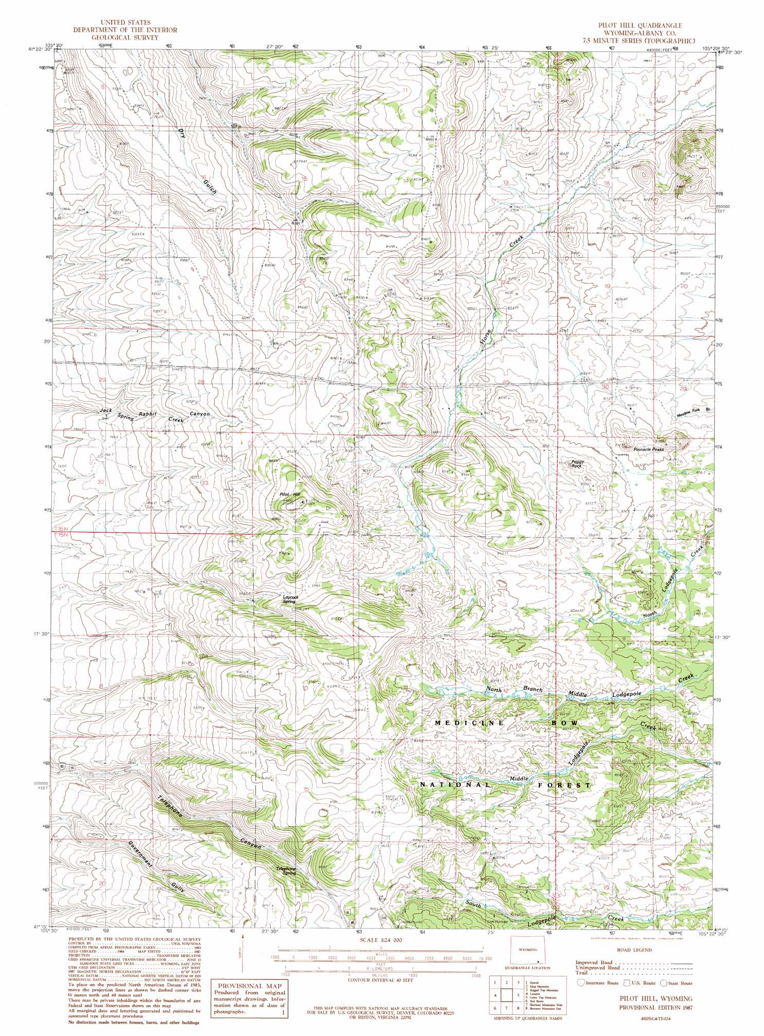
Pilot Hill Topo Map Wyoming
To zoom in, hover over the map of Pilot Hill
USGS Topo Quad 41105c4 - 1:24,000 scale
| Topo Map Name: | Pilot Hill |
| USGS Topo Quad ID: | 41105c4 |
| Print Size: | ca. 21 1/4" wide x 27" high |
| Southeast Coordinates: | 41.25° N latitude / 105.375° W longitude |
| Map Center Coordinates: | 41.3125° N latitude / 105.4375° W longitude |
| U.S. State: | WY |
| Filename: | o41105c4.jpg |
| Download Map JPG Image: | Pilot Hill topo map 1:24,000 scale |
| Map Type: | Topographic |
| Topo Series: | 7.5´ |
| Map Scale: | 1:24,000 |
| Source of Map Images: | United States Geological Survey (USGS) |
| Alternate Map Versions: |
Pilot Hill WY 1987, updated 1987 Download PDF Buy paper map Pilot Hill WY 1992, updated 1996 Download PDF Buy paper map Pilot Hill WY 2012 Download PDF Buy paper map Pilot Hill WY 2015 Download PDF Buy paper map |
| FStopo: | US Forest Service topo Pilot Hill is available: Download FStopo PDF Download FStopo TIF |
1:24,000 Topo Quads surrounding Pilot Hill
Bosler |
Bosler Se |
Baldy Mountain |
Goat Mountain |
Farthing |
Bamforth Lake |
Howell |
King Mountain |
Ragged Top Mountain |
Horse Creek |
Laramie Sw |
Laramie |
Pilot Hill |
Green Top Mountain |
Islay |
Hutton Lake |
Red Buttes |
Sherman Mountains West |
Sherman Mountains East |
Hecla |
Johnson Ranch |
Best Ranch |
Dale Creek |
Buford |
Granite |
> Back to 41105a1 at 1:100,000 scale
> Back to 41104a1 at 1:250,000 scale
> Back to U.S. Topo Maps home
Pilot Hill topo map: Gazetteer
Pilot Hill: Parks
Happy Jack Winter Sports Area elevation 2548m 8359′Pilot Hill: Springs
Laycock Spring elevation 2563m 8408′Telephone Spring elevation 2558m 8392′
Pilot Hill: Summits
Peggy Rock elevation 2542m 8339′Pilot Hill elevation 2691m 8828′
Pinnacle Peaks elevation 2553m 8375′
Pilot Hill: Trails
Ridge Camp Trail elevation 2575m 8448′Pilot Hill digital topo map on disk
Buy this Pilot Hill topo map showing relief, roads, GPS coordinates and other geographical features, as a high-resolution digital map file on DVD:
Eastern Wyoming & Western South Dakota
Buy digital topo maps: Eastern Wyoming & Western South Dakota