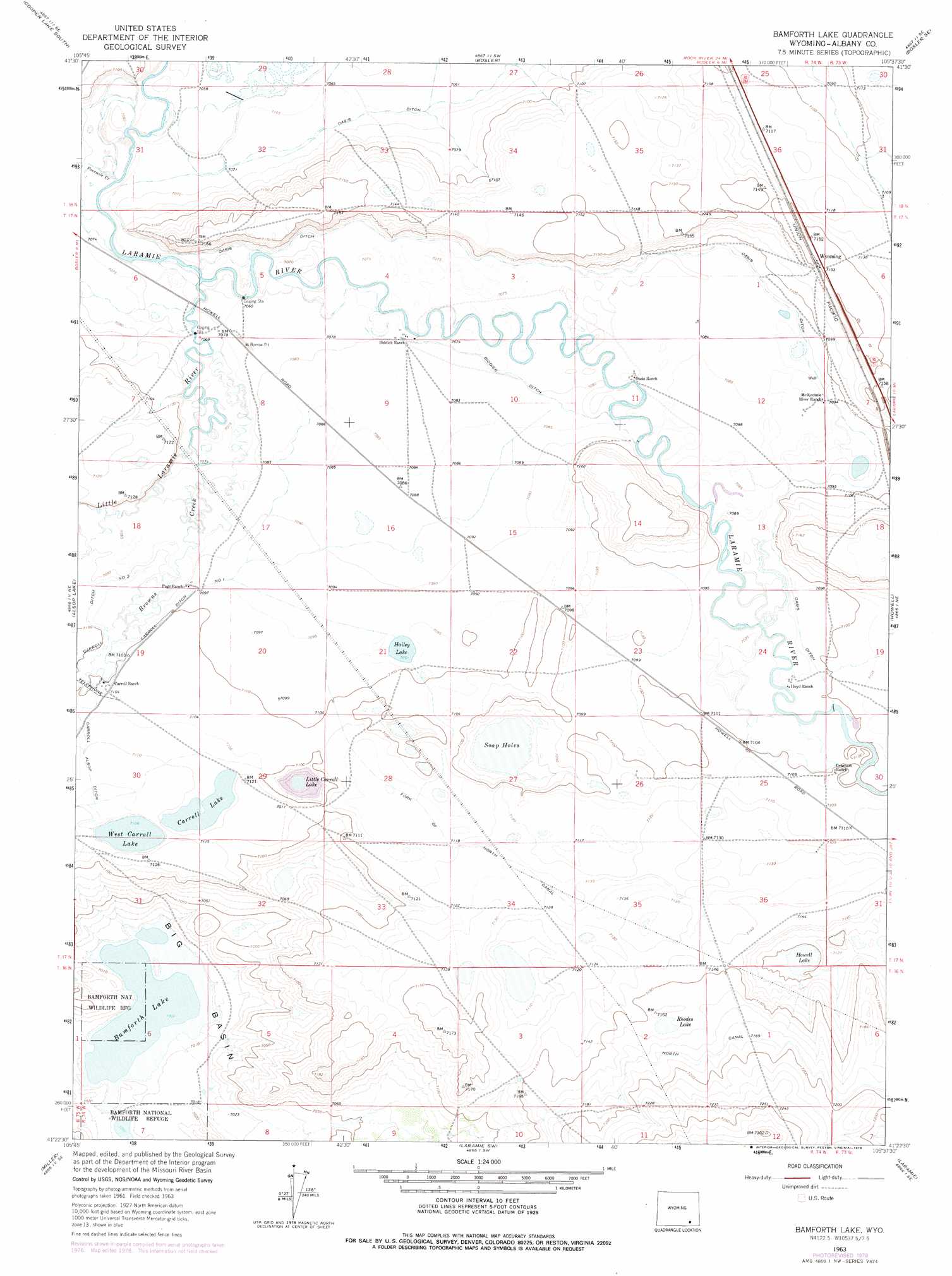
Bamforth Lake Topo Map Wyoming
To zoom in, hover over the map of Bamforth Lake
USGS Topo Quad 41105d6 - 1:24,000 scale
| Topo Map Name: | Bamforth Lake |
| USGS Topo Quad ID: | 41105d6 |
| Print Size: | ca. 21 1/4" wide x 27" high |
| Southeast Coordinates: | 41.375° N latitude / 105.625° W longitude |
| Map Center Coordinates: | 41.4375° N latitude / 105.6875° W longitude |
| U.S. State: | WY |
| Filename: | o41105d6.jpg |
| Download Map JPG Image: | Bamforth Lake topo map 1:24,000 scale |
| Map Type: | Topographic |
| Topo Series: | 7.5´ |
| Map Scale: | 1:24,000 |
| Source of Map Images: | United States Geological Survey (USGS) |
| Alternate Map Versions: |
Bamforth Lake WY 1963, updated 1965 Download PDF Buy paper map Bamforth Lake WY 1963, updated 1978 Download PDF Buy paper map Bamforth Lake WY 2012 Download PDF Buy paper map Bamforth Lake WY 2015 Download PDF Buy paper map |
1:24,000 Topo Quads surrounding Bamforth Lake
Rock River |
Cooper Lake North |
Lake Ione |
Sybille Springs |
Sheep Rock |
Big Judson |
Cooper Lake South |
Bosler |
Bosler Se |
Baldy Mountain |
James Lake |
Alsop Lake |
Bamforth Lake |
Howell |
King Mountain |
Millbrook |
La Marsh Creek West |
Laramie Sw |
Laramie |
Pilot Hill |
Sodergreen Lake |
Caldwell Lake |
Hutton Lake |
Red Buttes |
Sherman Mountains West |
> Back to 41105a1 at 1:100,000 scale
> Back to 41104a1 at 1:250,000 scale
> Back to U.S. Topo Maps home
Bamforth Lake topo map: Gazetteer
Bamforth Lake: Basins
Big Basin elevation 2137m 7011′Bamforth Lake: Canals
Biddick Ditch elevation 2159m 7083′Carroll Ditch Number 1 elevation 2164m 7099′
Carroll Ditch Number 2 elevation 2164m 7099′
Fork of North Canal elevation 2171m 7122′
North Canal elevation 2190m 7185′
Bamforth Lake: Lakes
Bamforth Lake elevation 2135m 7004′Carroll Lake elevation 2168m 7112′
Hailey Lake elevation 2162m 7093′
Howell Lake elevation 2164m 7099′
Little Carroll Lake elevation 2154m 7066′
Rhodes Lake elevation 2183m 7162′
Soap Holes elevation 2154m 7066′
West Carroll Lake elevation 2167m 7109′
Bamforth Lake: Populated Places
Wyoming elevation 2181m 7155′Bamforth Lake: Streams
Browns Creek elevation 2157m 7076′Fourmile Creek elevation 2153m 7063′
Little Laramie River elevation 2153m 7063′
Bamforth Lake digital topo map on disk
Buy this Bamforth Lake topo map showing relief, roads, GPS coordinates and other geographical features, as a high-resolution digital map file on DVD:
Eastern Wyoming & Western South Dakota
Buy digital topo maps: Eastern Wyoming & Western South Dakota