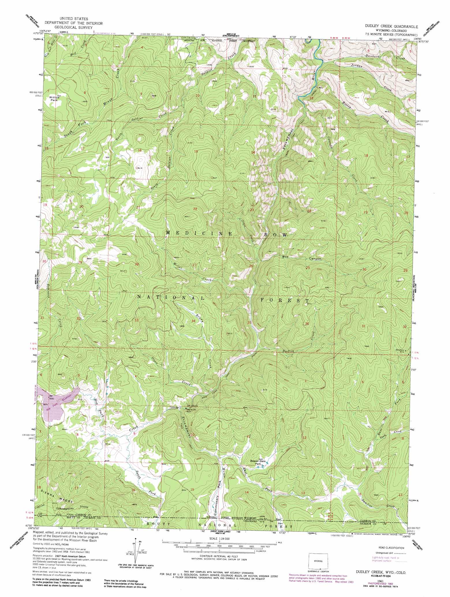
Dudley Creek Topo Map Wyoming
To zoom in, hover over the map of Dudley Creek
USGS Topo Quad 41106a7 - 1:24,000 scale
| Topo Map Name: | Dudley Creek |
| USGS Topo Quad ID: | 41106a7 |
| Print Size: | ca. 21 1/4" wide x 27" high |
| Southeast Coordinates: | 41° N latitude / 106.75° W longitude |
| Map Center Coordinates: | 41.0625° N latitude / 106.8125° W longitude |
| U.S. States: | WY, CO |
| Filename: | o41106a7.jpg |
| Download Map JPG Image: | Dudley Creek topo map 1:24,000 scale |
| Map Type: | Topographic |
| Topo Series: | 7.5´ |
| Map Scale: | 1:24,000 |
| Source of Map Images: | United States Geological Survey (USGS) |
| Alternate Map Versions: |
Dudley Creek WY 1961, updated 1963 Download PDF Buy paper map Dudley Creek WY 1961, updated 1973 Download PDF Buy paper map Dudley Creek WY 1961, updated 1984 Download PDF Buy paper map Dudley Creek WY 1961, updated 1984 Download PDF Buy paper map Dudley Creek WY 2012 Download PDF Buy paper map Dudley Creek WY 2015 Download PDF Buy paper map |
| FStopo: | US Forest Service topo Dudley Creek is available: Download FStopo PDF Download FStopo TIF |
1:24,000 Topo Quads surrounding Dudley Creek
Sharp Hill |
Indian Rocks |
Cow Creek Ranch |
Cow Creek |
Ryan Park |
Bridger Peak |
Red Mountain |
Encampment |
Gunst Reservoir |
Barcus Peak |
Fletcher Peak |
Solomon Creek |
Dudley Creek |
Blackhall Mountain |
Trent Creek |
Shield Mountain |
Elkhorn Mountain |
West Fork Lake |
Davis Peak |
Pearl |
Meaden Peak |
Hahns Peak |
Farwell Mountain |
Mount Zirkel |
Boettcher Lake |
> Back to 41106a1 at 1:100,000 scale
> Back to 41106a1 at 1:250,000 scale
> Back to U.S. Topo Maps home
Dudley Creek topo map: Gazetteer
Dudley Creek: Dams
Hog Park Dam elevation 2580m 8464′Dudley Creek: Flats
Commissary Park elevation 2552m 8372′Dudley Creek: Mines
Broadway Mine elevation 2821m 9255′Cascade Mine elevation 2323m 7621′
Dudley Creek: Parks
Beaver Dam Park elevation 2581m 8467′Commissary Park elevation 2561m 8402′
Encampment River Wildernes elevation 2388m 7834′
Ryan Park elevation 2659m 8723′
Willow Park elevation 2814m 9232′
Dudley Creek: Ranges
8464 elevation 2714m 8904′Dudley Creek: Reservoirs
Hog Park Reservoir elevation 2580m 8464′Dudley Creek: Streams
Billie Creek elevation 2537m 8323′Brady Creek elevation 2504m 8215′
Camper Creek elevation 2580m 8464′
Cascade Creek elevation 2578m 8458′
Coon Creek elevation 2678m 8786′
Damfino Creek elevation 2656m 8713′
Dudley Creek elevation 2493m 8179′
Dunkard Creek elevation 2525m 8284′
East Fork Encampment River elevation 2547m 8356′
Encampment River elevation 2506m 8221′
Hog Park Creek elevation 2507m 8225′
Jones Creek elevation 2763m 9064′
Jordan Creek elevation 2509m 8231′
Miller Creek elevation 2483m 8146′
North Soldier Creek elevation 2566m 8418′
Olson Creek elevation 2504m 8215′
Sams Creek elevation 2534m 8313′
South Fork Hog Park Creek elevation 2525m 8284′
South Soldier Creek elevation 2562m 8405′
Dudley Creek: Trails
Fireline Trail elevation 2831m 9288′Dudley Creek: Valleys
Box Canyon elevation 2460m 8070′Dudley Creek digital topo map on disk
Buy this Dudley Creek topo map showing relief, roads, GPS coordinates and other geographical features, as a high-resolution digital map file on DVD:
Eastern Wyoming & Western South Dakota
Buy digital topo maps: Eastern Wyoming & Western South Dakota