Arlington Topo Map Wyoming
To zoom in, hover over the map of Arlington
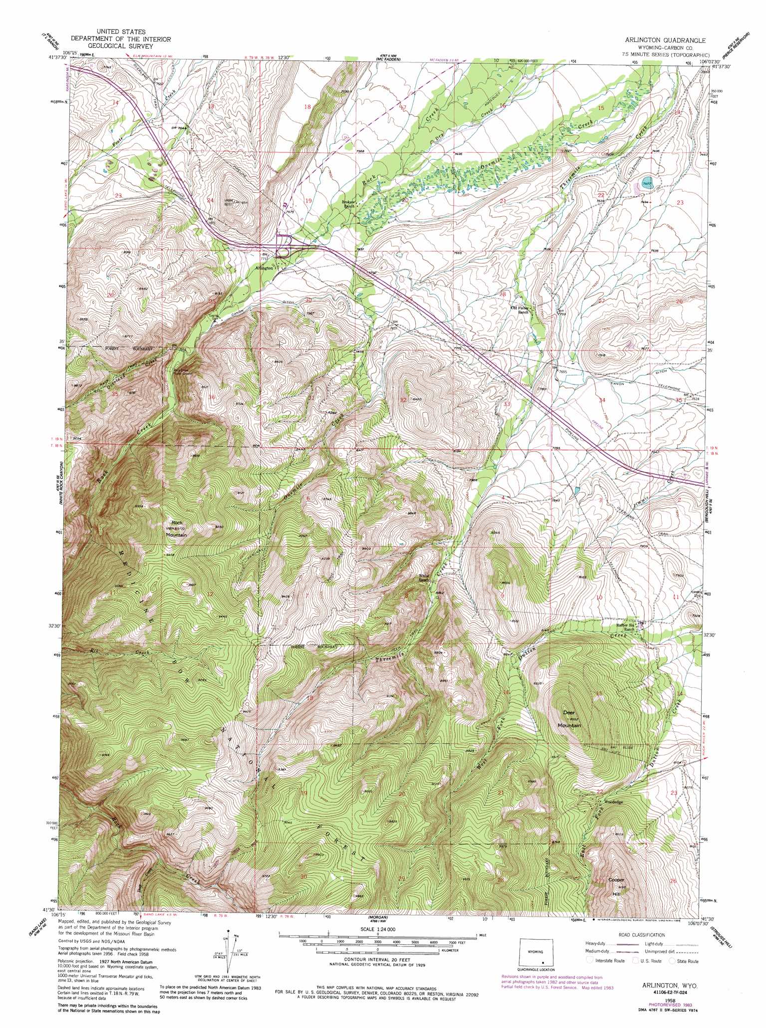
USGS Topo Quad 41106e2 - 1:24,000 scale
| Topo Map Name: | Arlington |
| USGS Topo Quad ID: | 41106e2 |
| Print Size: | ca. 21 1/4" wide x 27" high |
| Southeast Coordinates: | 41.5° N latitude / 106.125° W longitude |
| Map Center Coordinates: | 41.5625° N latitude / 106.1875° W longitude |
| U.S. State: | WY |
| Filename: | o41106e2.jpg |
| Download Map JPG Image: | Arlington topo map 1:24,000 scale |
| Map Type: | Topographic |
| Topo Series: | 7.5´ |
| Map Scale: | 1:24,000 |
| Source of Map Images: | United States Geological Survey (USGS) |
| Alternate Map Versions: |
Arlington WY 1958, updated 1959 Download PDF Buy paper map Arlington WY 1958, updated 1965 Download PDF Buy paper map Arlington WY 1958, updated 1980 Download PDF Buy paper map Arlington WY 1958, updated 1984 Download PDF Buy paper map Arlington WY 1992, updated 1996 Download PDF Buy paper map Arlington WY 2012 Download PDF Buy paper map Arlington WY 2015 Download PDF Buy paper map |
| FStopo: | US Forest Service topo Arlington is available: Download FStopo PDF Download FStopo TIF |
1:24,000 Topo Quads surrounding Arlington
Carbon |
Halfway Hill |
Pine Ridge |
Foote Creek Lake |
Wilcox |
Elk Mountain |
T L Ranch |
Mcfadden |
Pierce Reservoir |
Rock River |
Elk Mountain Sw |
White Rock Canyon |
Arlington |
Bengough Hill |
Big Judson |
Turpin Reservoir |
Sand Lake |
Morgan |
Strouss Hill |
James Lake |
Phantom Lake |
Medicine Bow Peak |
Centennial |
Rex Lake |
Millbrook |
> Back to 41106e1 at 1:100,000 scale
> Back to 41106a1 at 1:250,000 scale
> Back to U.S. Topo Maps home
Arlington topo map: Gazetteer
Arlington: Canals
Canon Ditch elevation 2344m 7690′Arlington: Mines
Copper King Mine elevation 2262m 7421′Cottontail Mine elevation 2330m 7644′
Rock Creek Mine elevation 2468m 8097′
Waterloo Prospects elevation 2637m 8651′
Arlington: Populated Places
Arlington elevation 2349m 7706′Woodedge elevation 2504m 8215′
Arlington: Streams
Deep Creek elevation 2648m 8687′Overland Creek elevation 2384m 7821′
West Fork Dutton Creek elevation 2372m 7782′
Arlington: Summits
Deer Mountain elevation 2724m 8937′Rock Mountain elevation 2959m 9708′
Arlington digital topo map on disk
Buy this Arlington topo map showing relief, roads, GPS coordinates and other geographical features, as a high-resolution digital map file on DVD:
Eastern Wyoming & Western South Dakota
Buy digital topo maps: Eastern Wyoming & Western South Dakota