Elk Mountain Sw Topo Map Wyoming
To zoom in, hover over the map of Elk Mountain Sw
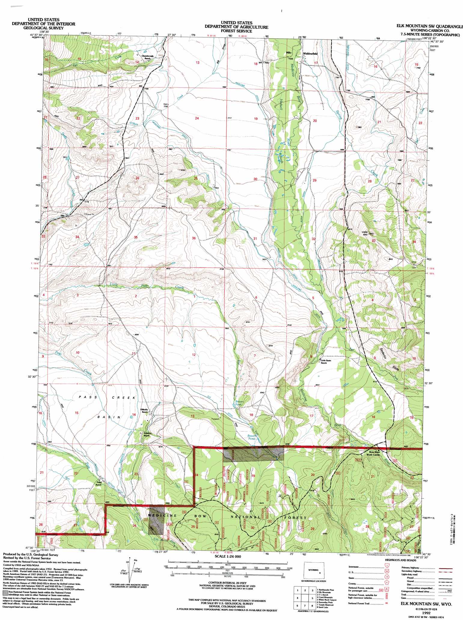
USGS Topo Quad 41106e4 - 1:24,000 scale
| Topo Map Name: | Elk Mountain Sw |
| USGS Topo Quad ID: | 41106e4 |
| Print Size: | ca. 21 1/4" wide x 27" high |
| Southeast Coordinates: | 41.5° N latitude / 106.375° W longitude |
| Map Center Coordinates: | 41.5625° N latitude / 106.4375° W longitude |
| U.S. State: | WY |
| Filename: | o41106e4.jpg |
| Download Map JPG Image: | Elk Mountain Sw topo map 1:24,000 scale |
| Map Type: | Topographic |
| Topo Series: | 7.5´ |
| Map Scale: | 1:24,000 |
| Source of Map Images: | United States Geological Survey (USGS) |
| Alternate Map Versions: |
Elk Mountain SW WY 1955, updated 1957 Download PDF Buy paper map Elk Mountain SW WY 1955, updated 1971 Download PDF Buy paper map Elk Mountain SW WY 1955, updated 1984 Download PDF Buy paper map Elk Mountain SW WY 1992, updated 1996 Download PDF Buy paper map Elk Mountain SW WY 2012 Download PDF Buy paper map Elk Mountain SW WY 2015 Download PDF Buy paper map |
| FStopo: | US Forest Service topo Elk Mountain SW is available: Download FStopo PDF Download FStopo TIF |
1:24,000 Topo Quads surrounding Elk Mountain Sw
Dana |
Hanna |
Carbon |
Halfway Hill |
Pine Ridge |
Coal Bank Basin |
Rattlesnake Pass |
Elk Mountain |
T L Ranch |
Mcfadden |
Oberg Ranch |
Coad Mountain |
Elk Mountain Sw |
White Rock Canyon |
Arlington |
Finley Reservoir |
Kennaday Peak |
Turpin Reservoir |
Sand Lake |
Morgan |
Cow Creek |
Ryan Park |
Phantom Lake |
Medicine Bow Peak |
Centennial |
> Back to 41106e1 at 1:100,000 scale
> Back to 41106a1 at 1:250,000 scale
> Back to U.S. Topo Maps home
Elk Mountain Sw topo map: Gazetteer
Elk Mountain Sw: Basins
Pass Creek Basin elevation 2389m 7837′Elk Mountain Sw: Canals
Alpha Ditch elevation 2335m 7660′Elk Ditch elevation 2537m 8323′
Haglund Ditch elevation 2349m 7706′
Harlin Robinson Ditch elevation 2441m 8008′
Highland Ditch elevation 2379m 7805′
School Section Ditch elevation 2434m 7985′
Elk Mountain Sw: Cliffs
Sederlin Slide elevation 2506m 8221′Elk Mountain Sw: Lakes
Beaver Pond elevation 2483m 8146′Beaver Ponds elevation 2516m 8254′
Burritt Lake elevation 2588m 8490′
Elk Mountain Sw: Populated Places
Milo elevation 2300m 7545′Widdowfield (historical) elevation 2308m 7572′
Elk Mountain Sw: Streams
Deer Creek elevation 2395m 7857′East Fork elevation 2442m 8011′
East Fork Little Pass Creek elevation 2442m 8011′
East Fork Medicine Bow River elevation 2426m 7959′
East Fork Pass Creek elevation 2479m 8133′
Spring Creek elevation 2304m 7559′
Turpin Creek elevation 2494m 8182′
Elk Mountain Sw digital topo map on disk
Buy this Elk Mountain Sw topo map showing relief, roads, GPS coordinates and other geographical features, as a high-resolution digital map file on DVD:
Eastern Wyoming & Western South Dakota
Buy digital topo maps: Eastern Wyoming & Western South Dakota