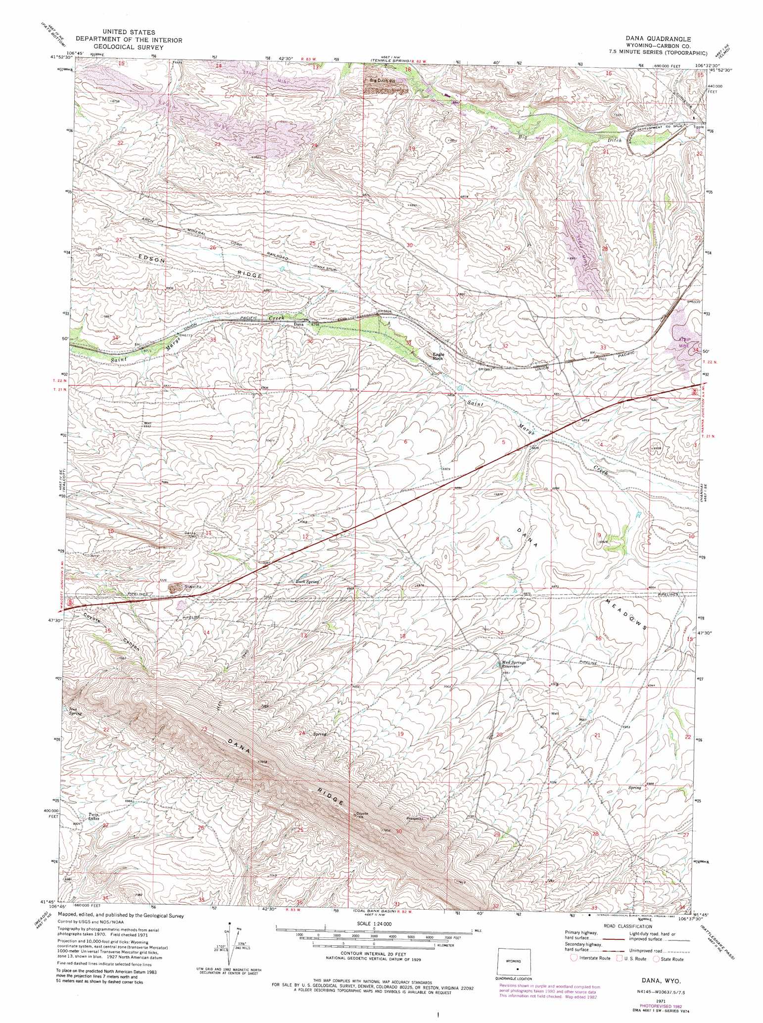
Dana Topo Map Wyoming
To zoom in, hover over the map of Dana
USGS Topo Quad 41106g6 - 1:24,000 scale
| Topo Map Name: | Dana |
| USGS Topo Quad ID: | 41106g6 |
| Print Size: | ca. 21 1/4" wide x 27" high |
| Southeast Coordinates: | 41.75° N latitude / 106.625° W longitude |
| Map Center Coordinates: | 41.8125° N latitude / 106.6875° W longitude |
| U.S. State: | WY |
| Filename: | o41106g6.jpg |
| Download Map JPG Image: | Dana topo map 1:24,000 scale |
| Map Type: | Topographic |
| Topo Series: | 7.5´ |
| Map Scale: | 1:24,000 |
| Source of Map Images: | United States Geological Survey (USGS) |
| Alternate Map Versions: |
Dana WY 1971, updated 1975 Download PDF Buy paper map Dana WY 1971, updated 1983 Download PDF Buy paper map Dana WY 2012 Download PDF Buy paper map Dana WY 2015 Download PDF Buy paper map |
1:24,000 Topo Quads surrounding Dana
Seminoe Dam Sw |
Seminoe Dam Se |
Schneider Ridge |
T E Ranch |
Difficulty |
Ferris Lake |
Pats Bottom |
Tenmile Spring |
Elmo |
Como West |
Fort Steele |
Walcott |
Dana |
Hanna |
Carbon |
Savage Ranch |
Meads |
Coal Bank Basin |
Rattlesnake Pass |
Elk Mountain |
Overland Crossing |
Overland |
Oberg Ranch |
Coad Mountain |
Elk Mountain Sw |
> Back to 41106e1 at 1:100,000 scale
> Back to 41106a1 at 1:250,000 scale
> Back to U.S. Topo Maps home
Dana topo map: Gazetteer
Dana: Flats
Dana Meadows elevation 2092m 6863′Dana: Lakes
Twin Lakes elevation 2113m 6932′Dana: Mines
Big Ditch Pit elevation 2047m 6715′Dana Mine elevation 2078m 6817′
Dana One Mine elevation 2094m 6870′
Dana Two Mine elevation 2095m 6873′
Hanna South Mine elevation 2110m 6922′
Lucky Annie Claims Mine elevation 2114m 6935′
Section Eighteen Pit Mine elevation 2032m 6666′
Seminoe Strip Mine elevation 2086m 6843′
Vanguard Number Two Energy Development Mine elevation 2092m 6863′
Vanguard Number Two Mine elevation 2021m 6630′
Dana: Reservoirs
Buck Spring elevation 2131m 6991′Mud Springs Reservoir elevation 2111m 6925′
Dana: Springs
Iron Spring elevation 2122m 6961′Dana: Summits
Eagle Rock elevation 2087m 6847′Dana digital topo map on disk
Buy this Dana topo map showing relief, roads, GPS coordinates and other geographical features, as a high-resolution digital map file on DVD:
Eastern Wyoming & Western South Dakota
Buy digital topo maps: Eastern Wyoming & Western South Dakota