Bridger Peak Topo Map Wyoming
To zoom in, hover over the map of Bridger Peak
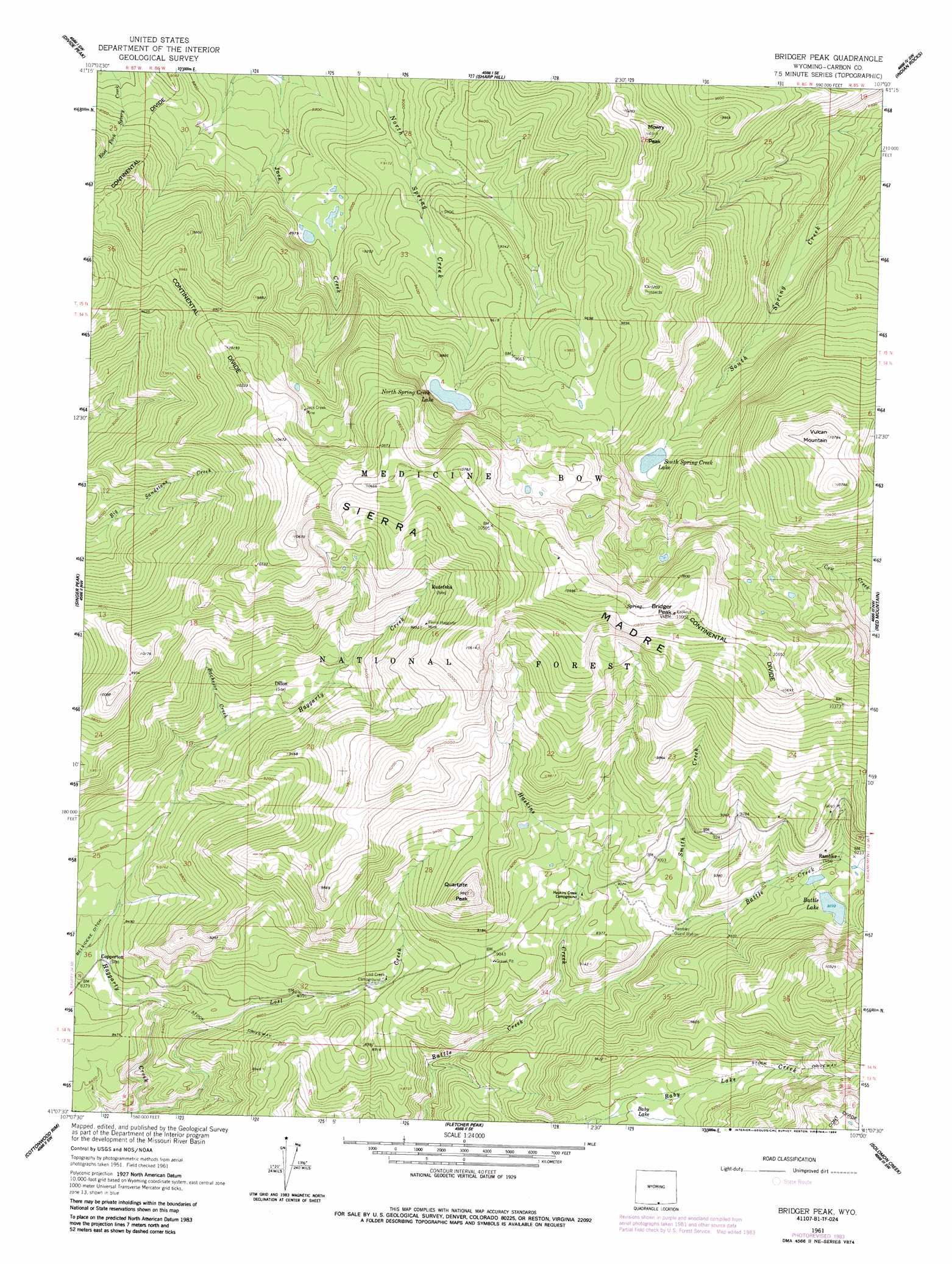
USGS Topo Quad 41107b1 - 1:24,000 scale
| Topo Map Name: | Bridger Peak |
| USGS Topo Quad ID: | 41107b1 |
| Print Size: | ca. 21 1/4" wide x 27" high |
| Southeast Coordinates: | 41.125° N latitude / 107° W longitude |
| Map Center Coordinates: | 41.1875° N latitude / 107.0625° W longitude |
| U.S. State: | WY |
| Filename: | o41107b1.jpg |
| Download Map JPG Image: | Bridger Peak topo map 1:24,000 scale |
| Map Type: | Topographic |
| Topo Series: | 7.5´ |
| Map Scale: | 1:24,000 |
| Source of Map Images: | United States Geological Survey (USGS) |
| Alternate Map Versions: |
Bridger Peak WY 1961, updated 1963 Download PDF Buy paper map Bridger Peak WY 1961, updated 1970 Download PDF Buy paper map Bridger Peak WY 1983, updated 1988 Download PDF Buy paper map Bridger Peak WY 2012 Download PDF Buy paper map Bridger Peak WY 2015 Download PDF Buy paper map |
| FStopo: | US Forest Service topo Bridger Peak is available: Download FStopo PDF Download FStopo TIF |
1:24,000 Topo Quads surrounding Bridger Peak
Pine Grove Ranch |
Middlewood Hill |
Jack Creek Reservoir |
Walck Ranch |
Saratoga |
Mccarty Ranch |
Divide Peak |
Sharp Hill |
Indian Rocks |
Cow Creek Ranch |
Tullis |
Singer Peak |
Bridger Peak |
Red Mountain |
Encampment |
Grieve Reservoir |
Cottonwood Rim |
Fletcher Peak |
Solomon Creek |
Dudley Creek |
Fly Creek |
Tumble Mountain |
Shield Mountain |
Elkhorn Mountain |
West Fork Lake |
> Back to 41107a1 at 1:100,000 scale
> Back to 41106a1 at 1:250,000 scale
> Back to U.S. Topo Maps home
Bridger Peak topo map: Gazetteer
Bridger Peak: Dams
North Spring Creek Dam elevation 3111m 10206′S Spring Creek Lake Dam elevation 2885m 9465′
South Spring Creek Lake Dam elevation 2891m 9484′
Bridger Peak: Lakes
Baby Lake elevation 2748m 9015′Battle Lake elevation 2816m 9238′
North Spring Creek Lake elevation 2970m 9744′
Bridger Peak: Mines
Big Chief Group Mine elevation 3243m 10639′Creede Property Mine elevation 3310m 10859′
Doan Rambler Mine elevation 3030m 9940′
Dreamland King Group Mine elevation 2896m 9501′
Ferris-Haggarty Mine elevation 3020m 9908′
Ferris-Haggerty Mine elevation 3076m 10091′
Island City Group Mine elevation 2996m 9829′
Jack Creek Mine elevation 3051m 10009′
Lena Shields Group Mine elevation 2973m 9753′
Octavia Prospect elevation 2754m 9035′
Bridger Peak: Populated Places
Copperton (historical) elevation 2552m 8372′Dillon (historical) elevation 2767m 9078′
Rambler (historical) elevation 2841m 9320′
Rudefeha (historical) elevation 2976m 9763′
Bridger Peak: Ranges
Sierra Madre elevation 3342m 10964′Bridger Peak: Reservoirs
North Spring Creek Reservoir elevation 3111m 10206′S Spring Creek Reservoir elevation 2885m 9465′
South Spring Creek Lake elevation 2885m 9465′
Bridger Peak: Streams
Alisha Creek elevation 2630m 8628′Bachelor Creek elevation 2690m 8825′
Doane Creek elevation 2807m 9209′
Green Creek elevation 2576m 8451′
Haskins Creek elevation 2627m 8618′
Lost Creek elevation 2520m 8267′
Smith Creek elevation 2695m 8841′
Vole Creek elevation 2768m 9081′
Bridger Peak: Summits
Bridger Peak elevation 3341m 10961′McCormick Peak elevation 3129m 10265′
Mowry Peak elevation 3135m 10285′
Quartzite Peak elevation 2999m 9839′
Vulcan Mountain elevation 3282m 10767′
Bridger Peak digital topo map on disk
Buy this Bridger Peak topo map showing relief, roads, GPS coordinates and other geographical features, as a high-resolution digital map file on DVD:
Eastern Wyoming & Western South Dakota
Buy digital topo maps: Eastern Wyoming & Western South Dakota