Horse Ranch Topo Map Wyoming
To zoom in, hover over the map of Horse Ranch
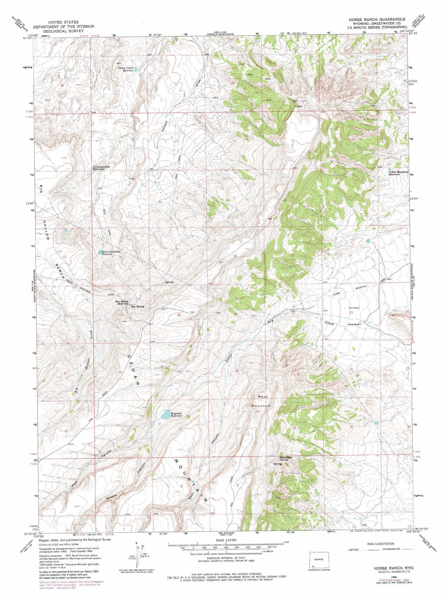
USGS Topo Quad 41109b8 - 1:24,000 scale
| Topo Map Name: | Horse Ranch |
| USGS Topo Quad ID: | 41109b8 |
| Print Size: | ca. 21 1/4" wide x 27" high |
| Southeast Coordinates: | 41.125° N latitude / 109.875° W longitude |
| Map Center Coordinates: | 41.1875° N latitude / 109.9375° W longitude |
| U.S. State: | WY |
| Filename: | o41109b8.jpg |
| Download Map JPG Image: | Horse Ranch topo map 1:24,000 scale |
| Map Type: | Topographic |
| Topo Series: | 7.5´ |
| Map Scale: | 1:24,000 |
| Source of Map Images: | United States Geological Survey (USGS) |
| Alternate Map Versions: |
Horse Ranch WY 1964, updated 1968 Download PDF Buy paper map Horse Ranch WY 1964, updated 1980 Download PDF Buy paper map Horse Ranch WY 2012 Download PDF Buy paper map Horse Ranch WY 2015 Download PDF Buy paper map |
1:24,000 Topo Quads surrounding Horse Ranch
Millersville |
Wildcat Butte |
Antelope Knoll |
Antelope Knoll Ne |
Massacre Hill |
Turtle Hill |
Butcher Knife Draw |
Needle Reservoir |
Winter Fat Reservoir |
Halfway Hollow West |
Reed Reservoir |
Soap Holes Reservoir |
Horse Ranch |
Black Spring Reservoir |
Devils Playground |
Lonetree |
Burntfork |
Mckinnon |
Antelope Wash |
Linwood Canyon |
Hole In The Rock |
Hoop Lake |
Phil Pico Mountain |
Jessen Butte |
Manila |
> Back to 41109a1 at 1:100,000 scale
> Back to 41108a1 at 1:250,000 scale
> Back to U.S. Topo Maps home
Horse Ranch topo map: Gazetteer
Horse Ranch: Dams
Wasatch Dam elevation 2356m 7729′Horse Ranch: Reservoirs
Box Spring Reservoir elevation 2360m 7742′Calamagrottis Reservoir elevation 2124m 6968′
Cedar Mountain Reservoir elevation 2093m 6866′
Green Sandstone Reservoir elevation 2204m 7230′
Ringdahl Reservoir elevation 2350m 7709′
Staley Corral Reservoir elevation 2076m 6811′
Wasatch Reservoir elevation 2356m 7729′
Horse Ranch: Springs
Box Spring elevation 2367m 7765′Moonshine Spring elevation 2348m 7703′
Horse Ranch: Summits
Cedar Mountain elevation 2532m 8307′Mass Mountain elevation 2497m 8192′
Horse Ranch: Valleys
East Canyon elevation 2255m 7398′Middle Canyon elevation 2358m 7736′
West Canyon elevation 2360m 7742′
Horse Ranch digital topo map on disk
Buy this Horse Ranch topo map showing relief, roads, GPS coordinates and other geographical features, as a high-resolution digital map file on DVD: