Burntfork Topo Map Wyoming
To zoom in, hover over the map of Burntfork
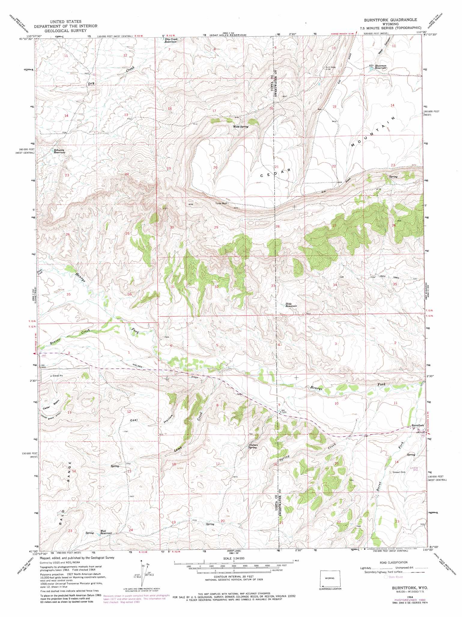
USGS Topo Quad 41110a1 - 1:24,000 scale
| Topo Map Name: | Burntfork |
| USGS Topo Quad ID: | 41110a1 |
| Print Size: | ca. 21 1/4" wide x 27" high |
| Southeast Coordinates: | 41° N latitude / 110° W longitude |
| Map Center Coordinates: | 41.0625° N latitude / 110.0625° W longitude |
| U.S. State: | WY |
| Filename: | o41110a1.jpg |
| Download Map JPG Image: | Burntfork topo map 1:24,000 scale |
| Map Type: | Topographic |
| Topo Series: | 7.5´ |
| Map Scale: | 1:24,000 |
| Source of Map Images: | United States Geological Survey (USGS) |
| Alternate Map Versions: |
Burntfork WY 1964, updated 1968 Download PDF Buy paper map Burntfork WY 1964, updated 1980 Download PDF Buy paper map Burntfork WY 2012 Download PDF Buy paper map Burntfork WY 2015 Download PDF Buy paper map |
| FStopo: | US Forest Service topo Burntfork is available: Download FStopo PDF Download FStopo TIF |
1:24,000 Topo Quads surrounding Burntfork
Mountain View |
Turtle Hill |
Butcher Knife Draw |
Needle Reservoir |
Winter Fat Reservoir |
Leavitt Bench |
Reed Reservoir |
Soap Holes Reservoir |
Horse Ranch |
Black Spring Reservoir |
Table Mountain |
Lonetree |
Burntfork |
Mckinnon |
Antelope Wash |
Gilbert Peak Ne |
Hole In The Rock |
Hoop Lake |
Phil Pico Mountain |
Jessen Butte |
Kings Peak |
Fox Lake |
Chepeta Lake |
Whiterocks Lake |
Leidy Peak |
> Back to 41110a1 at 1:100,000 scale
> Back to 41110a1 at 1:250,000 scale
> Back to U.S. Topo Maps home
Burntfork topo map: Gazetteer
Burntfork: Basins
Cedar Basin elevation 2336m 7664′Burntfork: Canals
Cedar Basin Ditch elevation 2353m 7719′Nielsen Ditch elevation 2245m 7365′
Burntfork: Populated Places
Burntfork elevation 2165m 7103′Burntfork: Ranges
Bald Range elevation 2446m 8024′Burntfork: Reservoirs
Behunin Reservoir elevation 2333m 7654′Dry Creek Reservoir elevation 2303m 7555′
Hussman Reservoir elevation 2549m 8362′
Slide Reservoir elevation 2299m 7542′
Well Reservoir elevation 2419m 7936′
Burntfork: Springs
Nielsen Spring elevation 2300m 7545′Webb Spring elevation 2539m 8330′
Burntfork: Streams
Beaver Creek elevation 2228m 7309′Burnt Fork elevation 2135m 7004′
Burnt Fork elevation 2135m 7004′
Lamb Creek elevation 2193m 7194′
Poison Creek elevation 2251m 7385′
Poison Creek elevation 2251m 7385′
Spring Creek elevation 2146m 7040′
Burntfork: Summits
Cedar Mountain elevation 2599m 8526′Burntfork: Valleys
Coal Hollow elevation 2215m 7267′Burntfork digital topo map on disk
Buy this Burntfork topo map showing relief, roads, GPS coordinates and other geographical features, as a high-resolution digital map file on DVD: