Buck Fever Ridge Topo Map Wyoming
To zoom in, hover over the map of Buck Fever Ridge
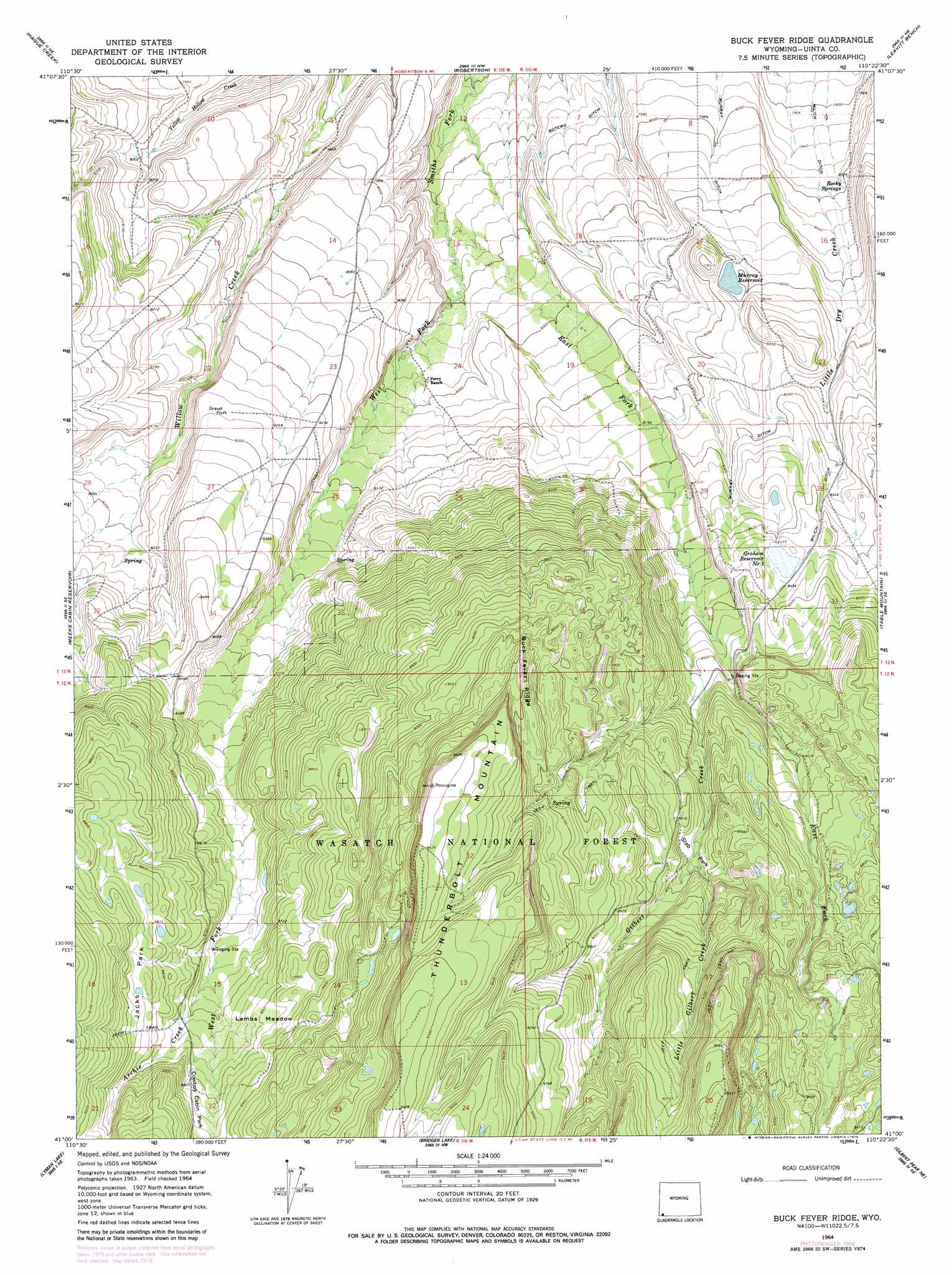
USGS Topo Quad 41110a4 - 1:24,000 scale
| Topo Map Name: | Buck Fever Ridge |
| USGS Topo Quad ID: | 41110a4 |
| Print Size: | ca. 21 1/4" wide x 27" high |
| Southeast Coordinates: | 41° N latitude / 110.375° W longitude |
| Map Center Coordinates: | 41.0625° N latitude / 110.4375° W longitude |
| U.S. State: | WY |
| Filename: | o41110a4.jpg |
| Download Map JPG Image: | Buck Fever Ridge topo map 1:24,000 scale |
| Map Type: | Topographic |
| Topo Series: | 7.5´ |
| Map Scale: | 1:24,000 |
| Source of Map Images: | United States Geological Survey (USGS) |
| Alternate Map Versions: |
Buck Fever Ridge WY 1964, updated 1968 Download PDF Buy paper map Buck Fever Ridge WY 1964, updated 1979 Download PDF Buy paper map Buck Fever Ridge WY 1998, updated 2001 Download PDF Buy paper map Buck Fever Ridge WY 2012 Download PDF Buy paper map Buck Fever Ridge WY 2015 Download PDF Buy paper map |
| FStopo: | US Forest Service topo Buck Fever Ridge is available: Download FStopo PDF Download FStopo TIF |
1:24,000 Topo Quads surrounding Buck Fever Ridge
Ragan |
Leroy |
Fort Bridger |
Mountain View |
Turtle Hill |
Piedmont Reservoir |
Hague Creek |
Robertson |
Leavitt Bench |
Reed Reservoir |
Moslander Reservoir |
Meeks Cabin Reservoir |
Buck Fever Ridge |
Table Mountain |
Lonetree |
Elizabeth Mountain |
Lyman Lake |
Bridger Lake |
Gilbert Peak Ne |
Hole In The Rock |
Red Knob |
Mount Lovenia |
Mount Powell |
Kings Peak |
Fox Lake |
> Back to 41110a1 at 1:100,000 scale
> Back to 41110a1 at 1:250,000 scale
> Back to U.S. Topo Maps home
Buck Fever Ridge topo map: Gazetteer
Buck Fever Ridge: Canals
Botero Ditch elevation 2400m 7874′Murray Ditch elevation 2529m 8297′
Buck Fever Ridge: Dams
Graham Dam elevation 2578m 8458′Tipperary Dam elevation 2498m 8195′
Buck Fever Ridge: Flats
Lambs Meadow elevation 2684m 8805′Buck Fever Ridge: Parks
Cowboy Cabin Park elevation 2695m 8841′Deadhorse Park elevation 2708m 8884′
Jacks Park elevation 2701m 8861′
Slab Park elevation 2665m 8743′
Buck Fever Ridge: Reservoirs
Graham Reservoir elevation 2578m 8458′Graham Reservoir Number 1 elevation 2574m 8444′
Murray Reservoir elevation 2498m 8195′
Tipperary Reservoir elevation 2498m 8195′
Buck Fever Ridge: Ridges
Buck Fever Ridge elevation 2814m 9232′Buck Fever Ridge: Springs
Cold Spring elevation 2367m 7765′Rocky Springs elevation 2438m 7998′
Buck Fever Ridge: Streams
Antone Creek elevation 2421m 7942′Archie Creek elevation 2638m 8654′
Archie Creek elevation 2660m 8727′
East Fork Smiths Fork elevation 2385m 7824′
East Fork Smiths Fork elevation 2385m 7824′
Gilbert Creek elevation 2544m 8346′
Gilbert Creek elevation 2544m 8346′
Little Gilbert Creek elevation 2658m 8720′
Little Gilbert Creek elevation 2658m 8720′
West Fork Smiths Fork elevation 2384m 7821′
West Fork Smiths Fork elevation 2384m 7821′
Buck Fever Ridge: Summits
Thunderbolt Mountain elevation 2905m 9530′Buck Fever Ridge digital topo map on disk
Buy this Buck Fever Ridge topo map showing relief, roads, GPS coordinates and other geographical features, as a high-resolution digital map file on DVD: