Meeks Cabin Reservoir Topo Map Wyoming
To zoom in, hover over the map of Meeks Cabin Reservoir
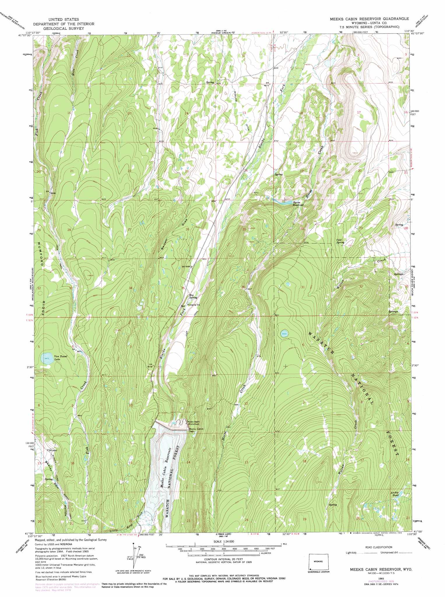
USGS Topo Quad 41110a5 - 1:24,000 scale
| Topo Map Name: | Meeks Cabin Reservoir |
| USGS Topo Quad ID: | 41110a5 |
| Print Size: | ca. 21 1/4" wide x 27" high |
| Southeast Coordinates: | 41° N latitude / 110.5° W longitude |
| Map Center Coordinates: | 41.0625° N latitude / 110.5625° W longitude |
| U.S. State: | WY |
| Filename: | o41110a5.jpg |
| Download Map JPG Image: | Meeks Cabin Reservoir topo map 1:24,000 scale |
| Map Type: | Topographic |
| Topo Series: | 7.5´ |
| Map Scale: | 1:24,000 |
| Source of Map Images: | United States Geological Survey (USGS) |
| Alternate Map Versions: |
Meeks Cabin Reservoir WY 1965, updated 1968 Download PDF Buy paper map Meeks Cabin Reservoir WY 1965, updated 1979 Download PDF Buy paper map Meeks Cabin Reservoir WY 1998, updated 2001 Download PDF Buy paper map Meeks Cabin Reservoir WY 2012 Download PDF Buy paper map Meeks Cabin Reservoir WY 2015 Download PDF Buy paper map |
| FStopo: | US Forest Service topo Meeks Cabin Reservoir is available: Download FStopo PDF Download FStopo TIF |
1:24,000 Topo Quads surrounding Meeks Cabin Reservoir
Guild Hollow |
Ragan |
Leroy |
Fort Bridger |
Mountain View |
Sulphur Creek Reservoir |
Piedmont Reservoir |
Hague Creek |
Robertson |
Leavitt Bench |
Pine Knoll |
Moslander Reservoir |
Meeks Cabin Reservoir |
Buck Fever Ridge |
Table Mountain |
Deadman Mountain |
Elizabeth Mountain |
Lyman Lake |
Bridger Lake |
Gilbert Peak Ne |
Christmas Meadows |
Red Knob |
Mount Lovenia |
Mount Powell |
Kings Peak |
> Back to 41110a1 at 1:100,000 scale
> Back to 41110a1 at 1:250,000 scale
> Back to U.S. Topo Maps home
Meeks Cabin Reservoir topo map: Gazetteer
Meeks Cabin Reservoir: Canals
Bigelow Ditch elevation 2492m 8175′Meeks Cabin Reservoir: Dams
Beaver Lake Dam elevation 2470m 8103′Byrne Dam elevation 2541m 8336′
Meeks Cabin Dam elevation 2626m 8615′
Meeks Cabin Dam elevation 2654m 8707′
Van Tassel Lake Dam elevation 2704m 8871′
Meeks Cabin Reservoir: Lakes
Archie Pond elevation 2801m 9189′Meeks Cabin Reservoir: Reservoirs
Beaver Lake elevation 2470m 8103′Byrne Reservoir elevation 2541m 8336′
Byrne Reservoir elevation 2535m 8316′
Meeks Cabin Reservoir elevation 2655m 8710′
Meeks Cabin Reservoir elevation 2626m 8615′
Van Tassel Lake elevation 2707m 8881′
Meeks Cabin Reservoir: Springs
Cold Spring elevation 2633m 8638′Meeks Cabin Reservoir: Streams
Drown Creek elevation 2703m 8868′Little West Fork Blacks Fork elevation 2620m 8595′
Little West Fork Blacks Fork elevation 2654m 8707′
Meeks Cabin Reservoir: Valleys
Balsam Draw elevation 2541m 8336′Meeks Cabin Reservoir digital topo map on disk
Buy this Meeks Cabin Reservoir topo map showing relief, roads, GPS coordinates and other geographical features, as a high-resolution digital map file on DVD: