Hague Creek Topo Map Wyoming
To zoom in, hover over the map of Hague Creek
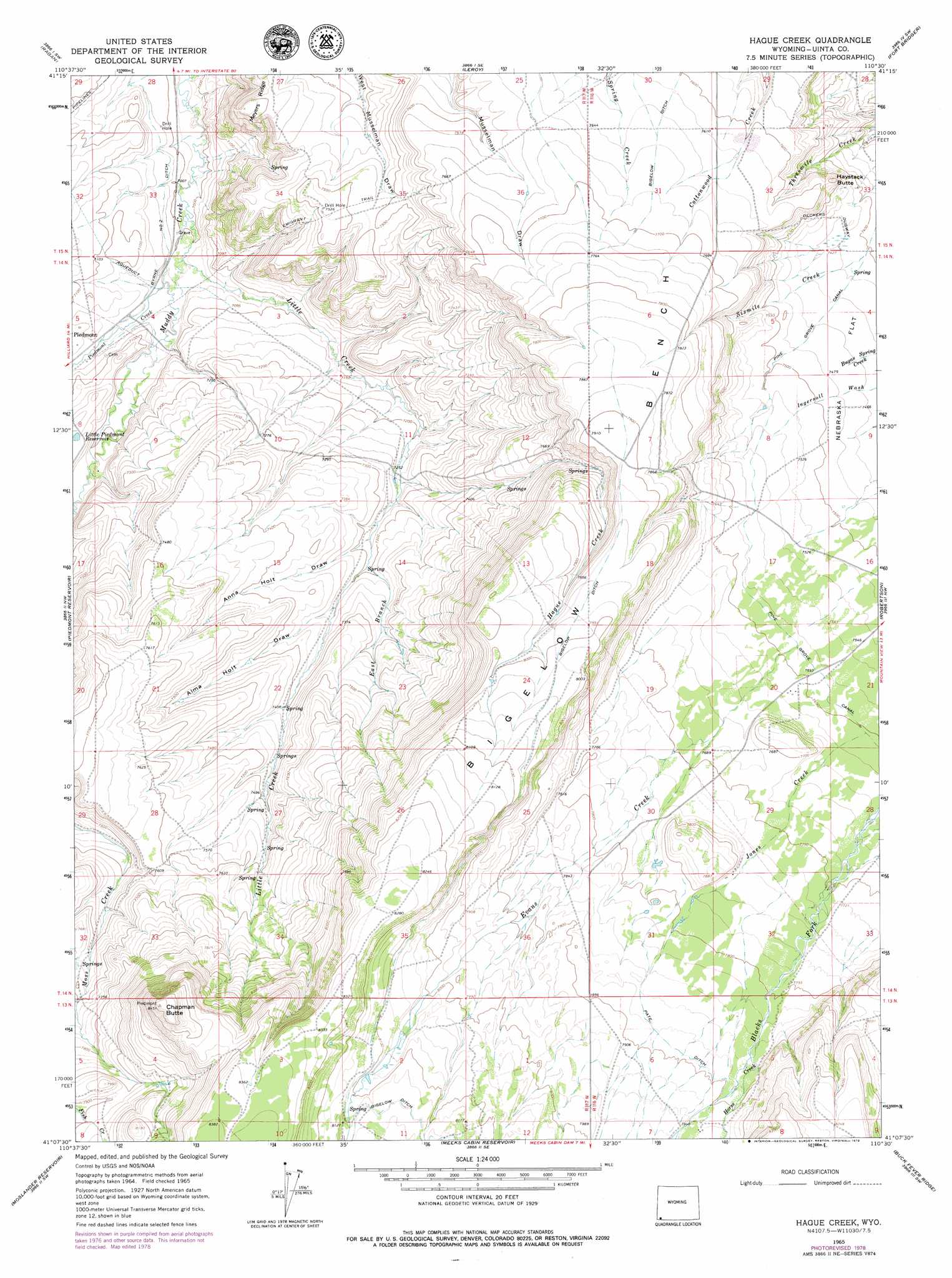
USGS Topo Quad 41110b5 - 1:24,000 scale
| Topo Map Name: | Hague Creek |
| USGS Topo Quad ID: | 41110b5 |
| Print Size: | ca. 21 1/4" wide x 27" high |
| Southeast Coordinates: | 41.125° N latitude / 110.5° W longitude |
| Map Center Coordinates: | 41.1875° N latitude / 110.5625° W longitude |
| U.S. State: | WY |
| Filename: | o41110b5.jpg |
| Download Map JPG Image: | Hague Creek topo map 1:24,000 scale |
| Map Type: | Topographic |
| Topo Series: | 7.5´ |
| Map Scale: | 1:24,000 |
| Source of Map Images: | United States Geological Survey (USGS) |
| Alternate Map Versions: |
Hague Creek WY 1965, updated 1968 Download PDF Buy paper map Hague Creek WY 1965, updated 1979 Download PDF Buy paper map Hague Creek WY 2012 Download PDF Buy paper map Hague Creek WY 2015 Download PDF Buy paper map |
1:24,000 Topo Quads surrounding Hague Creek
Little Dee Creek |
Meadow Draw |
Bridger |
Carter |
Austin Reservoir |
Guild Hollow |
Ragan |
Leroy |
Fort Bridger |
Mountain View |
Sulphur Creek Reservoir |
Piedmont Reservoir |
Hague Creek |
Robertson |
Leavitt Bench |
Pine Knoll |
Moslander Reservoir |
Meeks Cabin Reservoir |
Buck Fever Ridge |
Table Mountain |
Deadman Mountain |
Elizabeth Mountain |
Lyman Lake |
Bridger Lake |
Gilbert Peak Ne |
> Back to 41110a1 at 1:100,000 scale
> Back to 41110a1 at 1:250,000 scale
> Back to U.S. Topo Maps home
Hague Creek topo map: Gazetteer
Hague Creek: Benches
Bigelow Bench elevation 2449m 8034′Hague Creek: Canals
Byrne Number 2 Ditch elevation 2141m 7024′Pate Ditch elevation 2400m 7874′
Pine Grove Canal elevation 2312m 7585′
Hague Creek: Reservoirs
Little Piedmont Reservoir elevation 2188m 7178′Hague Creek: Ridges
Meyers Ridge elevation 2259m 7411′Hague Creek: Streams
East Branch Little Creek elevation 2225m 7299′Evans Creek elevation 2313m 7588′
Hague Creek elevation 2208m 7244′
Horse Creek elevation 2395m 7857′
Horse Creek elevation 2395m 7857′
Little Creek elevation 2139m 7017′
Piedmont Creek elevation 2141m 7024′
Sixmile Creek elevation 2257m 7404′
Hague Creek: Summits
Chapman Butte elevation 2563m 8408′Haystack Butte elevation 2264m 7427′
Hague Creek: Valleys
Alma Holt Draw elevation 2236m 7335′Anna Holt Draw elevation 2221m 7286′
Hague Creek digital topo map on disk
Buy this Hague Creek topo map showing relief, roads, GPS coordinates and other geographical features, as a high-resolution digital map file on DVD: