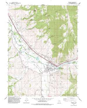
Morgan Topo Map Utah
To zoom in, hover over the map of Morgan
USGS Topo Quad 41111a6 - 1:24,000 scale
| Topo Map Name: | Morgan |
| USGS Topo Quad ID: | 41111a6 |
| Print Size: | ca. 21 1/4" wide x 27" high |
| Southeast Coordinates: | 41° N latitude / 111.625° W longitude |
| Map Center Coordinates: | 41.0625° N latitude / 111.6875° W longitude |
| U.S. State: | UT |
| Filename: | o41111a6.jpg |
| Download Map JPG Image: | Morgan topo map 1:24,000 scale |
| Map Type: | Topographic |
| Topo Series: | 7.5´ |
| Map Scale: | 1:24,000 |
| Source of Map Images: | United States Geological Survey (USGS) |
| Alternate Map Versions: |
Morgan UT 1961, updated 1963 Download PDF Buy paper map Morgan UT 1961, updated 1978 Download PDF Buy paper map Morgan UT 1961, updated 1986 Download PDF Buy paper map Morgan UT 1991, updated 1991 Download PDF Buy paper map Morgan UT 1997, updated 2001 Download PDF Buy paper map Morgan UT 2011 Download PDF Buy paper map Morgan UT 2014 Download PDF Buy paper map |
1:24,000 Topo Quads surrounding Morgan
> Back to 41111a1 at 1:100,000 scale
> Back to 41110a1 at 1:250,000 scale
> Back to U.S. Topo Maps home
Morgan topo map: Gazetteer
Morgan: Basins
The Valleys elevation 2101m 6893′Morgan: Canals
Enterprise Ditch elevation 1517m 4977′North Morgan Canal elevation 1545m 5068′
Morgan: Dams
Como Diversion elevation 1549m 5082′Stoddard Diversion Dam elevation 1519m 4983′
Morgan: Guts
Stoddard Slough elevation 1524m 5000′Morgan: Parks
Round Valley Wildlife Management Area elevation 2209m 7247′Morgan: Populated Places
Como Springs elevation 1562m 5124′Enterprise elevation 1512m 4960′
Littleton elevation 1539m 5049′
Milton elevation 1528m 5013′
Morgan elevation 1545m 5068′
Richville elevation 1559m 5114′
Stoddard elevation 1531m 5022′
Morgan: Post Offices
Morgan Post Office elevation 1543m 5062′Morgan: Streams
Center Fork Deep Creek elevation 1595m 5232′Dalton Creek elevation 1503m 4931′
Deep Creek elevation 1521m 4990′
East Canyon Creek elevation 1524m 5000′
Left Fork Deep Creek elevation 1632m 5354′
Line Creek elevation 1521m 4990′
North Fork Deep Creek elevation 1563m 5127′
Smith Creek elevation 1505m 4937′
Morgan: Summits
Haystack Mountain elevation 2004m 6574′The Head elevation 2626m 8615′
Morgan: Valleys
Big Hollow elevation 1537m 5042′Cedar Canyon elevation 1559m 5114′
Devils Hollow elevation 1929m 6328′
Geary Hollow elevation 1581m 5187′
Mahogany Canyon elevation 1561m 5121′
Metz Hollow elevation 1561m 5121′
Pine Canyon elevation 1548m 5078′
Right Hand Fork Norwood Canyon elevation 1796m 5892′
Right Hand Fork Roswells Canyon elevation 1582m 5190′
Roswells Canyon elevation 1519m 4983′
Round Valley elevation 1551m 5088′
Spring Hollow elevation 1524m 5000′
Taggart Hollow elevation 1564m 5131′
Tonks Canyon elevation 1569m 5147′
Upper Weber Canyon elevation 1547m 5075′
Morgan digital topo map on disk
Buy this Morgan topo map showing relief, roads, GPS coordinates and other geographical features, as a high-resolution digital map file on DVD:


