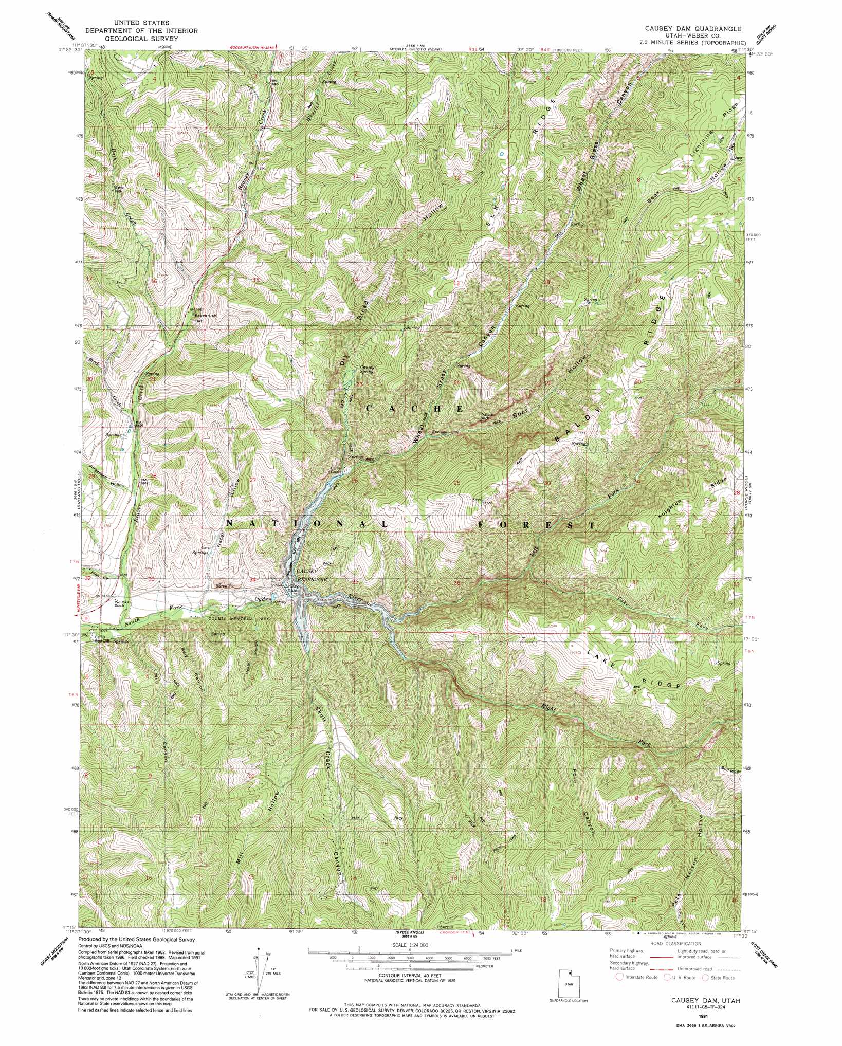
Causey Dam Topo Map Utah
To zoom in, hover over the map of Causey Dam
USGS Topo Quad 41111c5 - 1:24,000 scale
| Topo Map Name: | Causey Dam |
| USGS Topo Quad ID: | 41111c5 |
| Print Size: | ca. 21 1/4" wide x 27" high |
| Southeast Coordinates: | 41.25° N latitude / 111.5° W longitude |
| Map Center Coordinates: | 41.3125° N latitude / 111.5625° W longitude |
| U.S. State: | UT |
| Filename: | o41111c5.jpg |
| Download Map JPG Image: | Causey Dam topo map 1:24,000 scale |
| Map Type: | Topographic |
| Topo Series: | 7.5´ |
| Map Scale: | 1:24,000 |
| Source of Map Images: | United States Geological Survey (USGS) |
| Alternate Map Versions: |
Causey Dam UT 1964, updated 1966 Download PDF Buy paper map Causey Dam UT 1964, updated 1977 Download PDF Buy paper map Causey Dam UT 1964, updated 1986 Download PDF Buy paper map Causey Dam UT 1991, updated 1991 Download PDF Buy paper map Causey Dam UT 1998, updated 2000 Download PDF Buy paper map Causey Dam UT 2011 Download PDF Buy paper map Causey Dam UT 2014 Download PDF Buy paper map |
| FStopo: | US Forest Service topo Causey Dam is available: Download FStopo PDF Download FStopo TIF |
1:24,000 Topo Quads surrounding Causey Dam
Paradise |
Porcupine Reservoir |
Hardware Ranch |
Curtis Ridge |
Birch Creek Reservoirs |
James Peak |
Sharp Mountain |
Monte Cristo Peak |
Dairy Ridge |
Meachum Ridge |
Huntsville |
Browns Hole |
Causey Dam |
Horse Ridge |
Peck Canyon |
Snow Basin |
Durst Mountain |
Bybee Knoll |
Lost Creek Dam |
Francis Canyon |
Peterson |
Morgan |
Devils Slide |
Henefer |
Heiners Creek |
> Back to 41111a1 at 1:100,000 scale
> Back to 41110a1 at 1:250,000 scale
> Back to U.S. Topo Maps home
Causey Dam topo map: Gazetteer
Causey Dam: Dams
Causey Dam elevation 1736m 5695′Causey Dam: Flats
Sagebrush Flat elevation 1803m 5915′Causey Dam: Parks
Weber County Memorial Park elevation 1673m 5488′Causey Dam: Populated Places
Causey Estates elevation 2029m 6656′Causey Dam: Reservoirs
Causey Reservoir elevation 1736m 5695′Causey Dam: Ridges
Baldy Ridge elevation 2397m 7864′Elk Ridge elevation 2308m 7572′
Causey Dam: Springs
Causey Spring elevation 1912m 6272′Causey Dam: Streams
Beaver Creek elevation 1640m 5380′Birch Creek elevation 1739m 5705′
Lake Fork elevation 1834m 6017′
Left Fork South Fork Ogden River elevation 1736m 5695′
Pine Creek elevation 1659m 5442′
Right Fork South Fork Ogden River elevation 1736m 5695′
Rock Creek elevation 1790m 5872′
Wheeler Creek elevation 1929m 6328′
Causey Dam: Valleys
Bear Hollow elevation 1802m 5912′Dry Bread Hollow elevation 1744m 5721′
Heater Hollow elevation 1683m 5521′
Jorgensen Hollow elevation 1707m 5600′
Left Fork Pete Nelson Hollow elevation 2081m 6827′
Mill Canyon elevation 1645m 5396′
Mill Hollow elevation 1790m 5872′
Pete Nelson Hollow elevation 1899m 6230′
Pole Canyon elevation 1872m 6141′
Red Canyon elevation 1656m 5433′
Skull Crack Canyon elevation 1736m 5695′
Water Hollow elevation 1695m 5561′
Wheat Grass Canyon elevation 1736m 5695′
Causey Dam digital topo map on disk
Buy this Causey Dam topo map showing relief, roads, GPS coordinates and other geographical features, as a high-resolution digital map file on DVD: