Birch Creek Reservoirs Topo Map Utah
To zoom in, hover over the map of Birch Creek Reservoirs
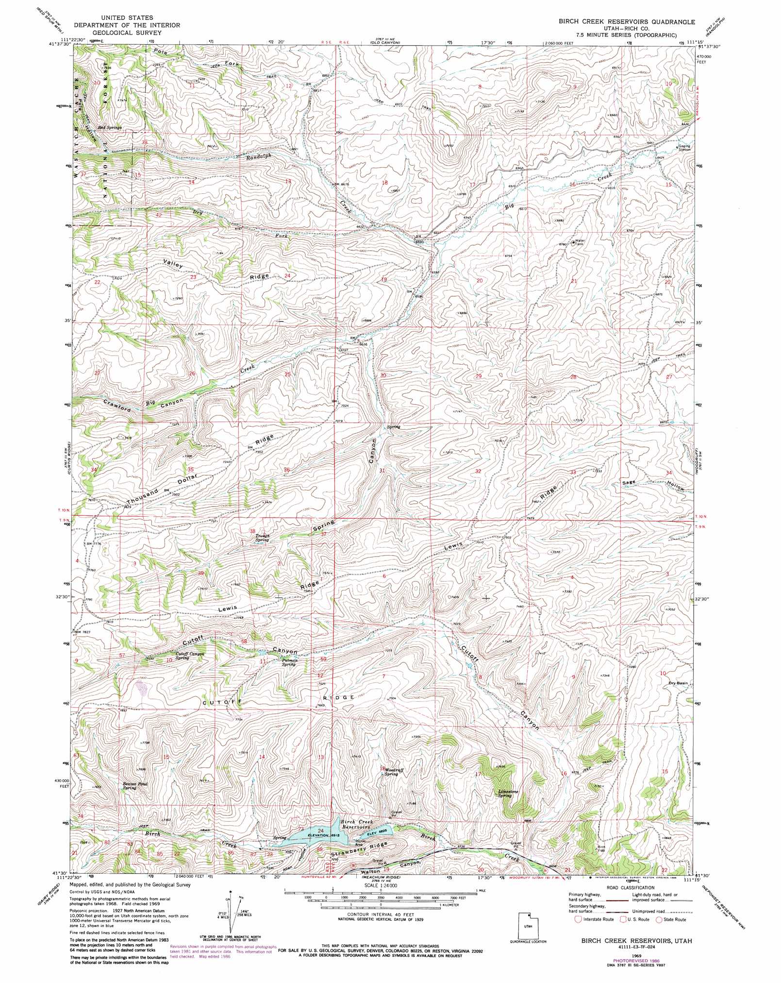
USGS Topo Quad 41111e3 - 1:24,000 scale
| Topo Map Name: | Birch Creek Reservoirs |
| USGS Topo Quad ID: | 41111e3 |
| Print Size: | ca. 21 1/4" wide x 27" high |
| Southeast Coordinates: | 41.5° N latitude / 111.25° W longitude |
| Map Center Coordinates: | 41.5625° N latitude / 111.3125° W longitude |
| U.S. State: | UT |
| Filename: | o41111e3.jpg |
| Download Map JPG Image: | Birch Creek Reservoirs topo map 1:24,000 scale |
| Map Type: | Topographic |
| Topo Series: | 7.5´ |
| Map Scale: | 1:24,000 |
| Source of Map Images: | United States Geological Survey (USGS) |
| Alternate Map Versions: |
Birch Creek Reservoirs UT 1969, updated 1973 Download PDF Buy paper map Birch Creek Reservoirs UT 1969, updated 1981 Download PDF Buy paper map Birch Creek Reservoirs UT 1969, updated 1986 Download PDF Buy paper map Birch Creek Reservoirs UT 1998, updated 2001 Download PDF Buy paper map Birch Creek Reservoirs UT 2011 Download PDF Buy paper map Birch Creek Reservoirs UT 2014 Download PDF Buy paper map |
| FStopo: | US Forest Service topo Birch Creek Reservoirs is available: Download FStopo PDF Download FStopo TIF |
1:24,000 Topo Quads surrounding Birch Creek Reservoirs
Temple Peak |
Meadowville |
Laketown |
Sage Creek |
Leefe |
Boulder Mountain |
Red Spur Mountain |
Old Canyon |
Randolph |
Rex Peak |
Hardware Ranch |
Curtis Ridge |
Birch Creek Reservoirs |
Woodruff |
Woodruff Narrows |
Monte Cristo Peak |
Dairy Ridge |
Meachum Ridge |
Neponset Reservoir Nw |
Neponset Reservoir Ne |
Causey Dam |
Horse Ridge |
Peck Canyon |
Mckay Hollow |
Murphy Ridge |
> Back to 41111e1 at 1:100,000 scale
> Back to 41110a1 at 1:250,000 scale
> Back to U.S. Topo Maps home
Birch Creek Reservoirs topo map: Gazetteer
Birch Creek Reservoirs: Flats
Woodruff Pastures elevation 2099m 6886′Birch Creek Reservoirs: Reservoirs
Birch Creek Reservoirs elevation 2109m 6919′Birch Creek Reservoirs: Ridges
Cutoff Ridge elevation 2405m 7890′Lewis Ridge elevation 2285m 7496′
Thousand Dollar Ridge elevation 2284m 7493′
Valley Ridge elevation 2199m 7214′
Birch Creek Reservoirs: Springs
Beaver Pond Spring elevation 2203m 7227′Cutoff Canyon Spring elevation 2255m 7398′
Limestone Spring elevation 2136m 7007′
Putman Spring elevation 2194m 7198′
Red Springs elevation 2166m 7106′
Trough Spring elevation 2177m 7142′
Woodruff Spring elevation 2142m 7027′
Birch Creek Reservoirs: Streams
Dry Fork elevation 2015m 6610′Pole Fork elevation 2086m 6843′
Randolph Creek elevation 2000m 6561′
Birch Creek Reservoirs: Valleys
Allan Hollow elevation 2112m 6929′Crawford Canyon elevation 1998m 6555′
Cutoff Canyon elevation 2033m 6669′
Pole Hollow elevation 2149m 7050′
Spring Canyon elevation 2025m 6643′
Walton Canyon elevation 2056m 6745′
Birch Creek Reservoirs digital topo map on disk
Buy this Birch Creek Reservoirs topo map showing relief, roads, GPS coordinates and other geographical features, as a high-resolution digital map file on DVD: