Garden City Topo Map Utah
To zoom in, hover over the map of Garden City
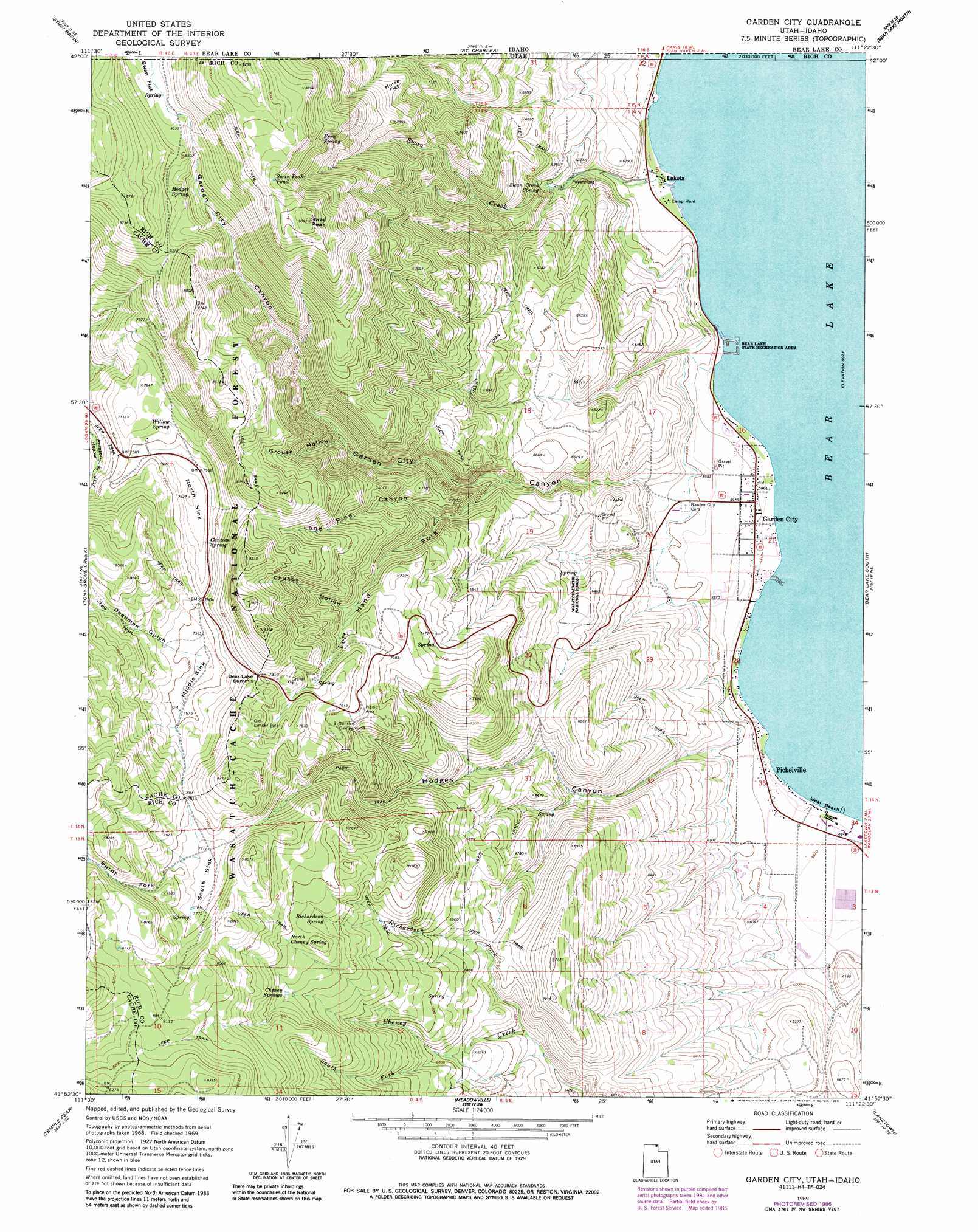
USGS Topo Quad 41111h4 - 1:24,000 scale
| Topo Map Name: | Garden City |
| USGS Topo Quad ID: | 41111h4 |
| Print Size: | ca. 21 1/4" wide x 27" high |
| Southeast Coordinates: | 41.875° N latitude / 111.375° W longitude |
| Map Center Coordinates: | 41.9375° N latitude / 111.4375° W longitude |
| U.S. States: | UT, ID |
| Filename: | o41111h4.jpg |
| Download Map JPG Image: | Garden City topo map 1:24,000 scale |
| Map Type: | Topographic |
| Topo Series: | 7.5´ |
| Map Scale: | 1:24,000 |
| Source of Map Images: | United States Geological Survey (USGS) |
| Alternate Map Versions: |
Garden City UT 1969, updated 1973 Download PDF Buy paper map Garden City UT 1969, updated 1985 Download PDF Buy paper map Garden City UT 1969, updated 1986 Download PDF Buy paper map Garden City UT 1969, updated 1986 Download PDF Buy paper map Garden City UT 1998, updated 2001 Download PDF Buy paper map Garden City UT 2011 Download PDF Buy paper map Garden City UT 2014 Download PDF Buy paper map |
| FStopo: | US Forest Service topo Garden City is available: Download FStopo PDF Download FStopo TIF |
1:24,000 Topo Quads surrounding Garden City
Mink Creek |
Paris Peak |
Paris |
Dingle |
Pegram |
Mapleton |
Egan Basin |
Saint Charles |
Bear Lake North |
Pegram Creek |
Naomi Peak |
Tony Grove Creek |
Garden City |
Bear Lake South |
Sheeppen Creek |
Mount Elmer |
Temple Peak |
Meadowville |
Laketown |
Sage Creek |
Logan Peak |
Boulder Mountain |
Red Spur Mountain |
Old Canyon |
Randolph |
> Back to 41111e1 at 1:100,000 scale
> Back to 41110a1 at 1:250,000 scale
> Back to U.S. Topo Maps home
Garden City topo map: Gazetteer
Garden City: Airports
Lake-Air Airport elevation 1807m 5928′Garden City: Basins
Middle Sink elevation 2302m 7552′North Sink elevation 2268m 7440′
South Sink elevation 2349m 7706′
Garden City: Beaches
Ideal Beach elevation 1807m 5928′Garden City: Flats
Horse Flat elevation 2321m 7614′Swan Flat elevation 2534m 8313′
Swan Flat elevation 2537m 8323′
Garden City: Gaps
Bear Lake Summit elevation 2383m 7818′Garden City: Lakes
Swan Peak Pond elevation 2685m 8809′Garden City: Parks
Bear Lake State Park elevation 1821m 5974′Garden City: Populated Places
Fays Trailer Park elevation 2043m 6702′Garden elevation 1830m 6003′
Garden City elevation 1819m 5967′
Lakota elevation 1808m 5931′
Old Limber Pine elevation 2407m 7896′
Pickelville elevation 1809m 5935′
Garden City: Springs
Canteen Spring elevation 2300m 7545′Cheney Springs elevation 2280m 7480′
Fern Spring elevation 2605m 8546′
Hodges Spring elevation 2558m 8392′
North Cheney Spring elevation 2316m 7598′
Richardson Spring elevation 2282m 7486′
Swan Creek Spring elevation 1890m 6200′
Willow Spring elevation 2330m 7644′
Garden City: Streams
Burnt Fork elevation 2353m 7719′Richardson Fork elevation 1981m 6499′
South Fork Cheney Creek elevation 2062m 6765′
Swan Creek elevation 1807m 5928′
Garden City: Summits
Bridger Peak elevation 2818m 9245′Swan Peak elevation 2771m 9091′
Garden City: Trails
Limber Pine Trail elevation 2415m 7923′Garden City: Valleys
Chubby Hollow elevation 2223m 7293′Deadman Gulch elevation 2320m 7611′
Garden City Canyon elevation 1855m 6085′
Grouse Hollow elevation 2160m 7086′
Hodges Canyon elevation 1829m 6000′
Left Hand Fork Lone Pine Canyon elevation 2069m 6788′
Lone Pine Canyon elevation 1969m 6459′
Garden City digital topo map on disk
Buy this Garden City topo map showing relief, roads, GPS coordinates and other geographical features, as a high-resolution digital map file on DVD: