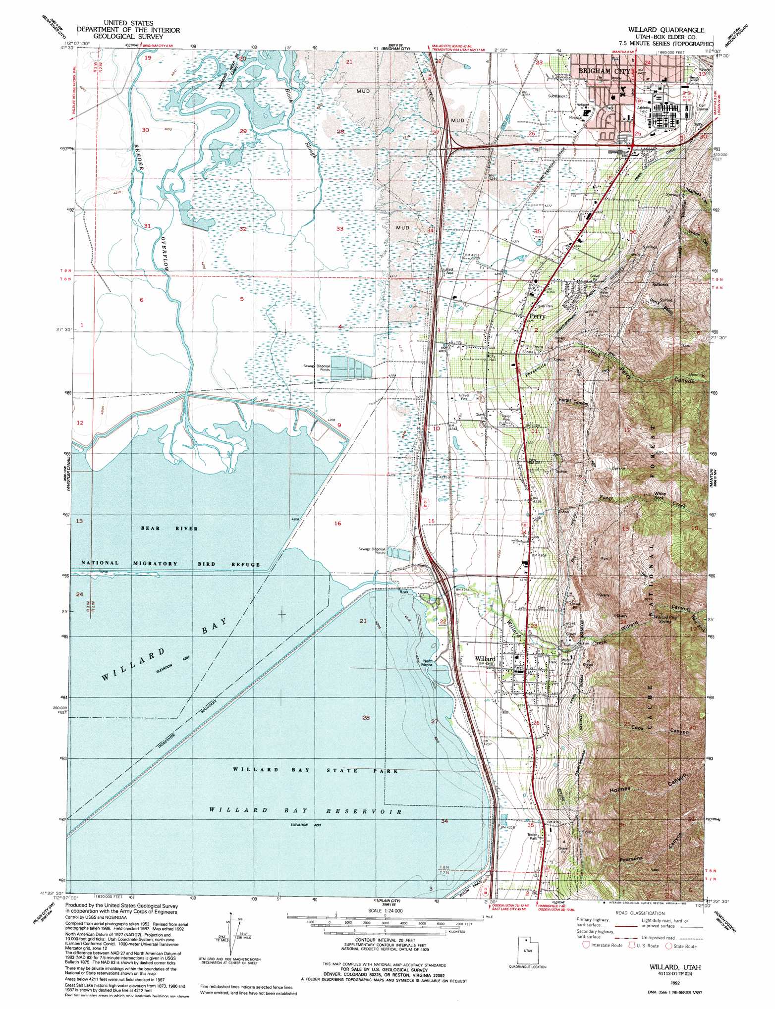
Willard Topo Map Utah
To zoom in, hover over the map of Willard
USGS Topo Quad 41112d1 - 1:24,000 scale
| Topo Map Name: | Willard |
| USGS Topo Quad ID: | 41112d1 |
| Print Size: | ca. 21 1/4" wide x 27" high |
| Southeast Coordinates: | 41.375° N latitude / 112° W longitude |
| Map Center Coordinates: | 41.4375° N latitude / 112.0625° W longitude |
| U.S. State: | UT |
| Filename: | o41112d1.jpg |
| Download Map JPG Image: | Willard topo map 1:24,000 scale |
| Map Type: | Topographic |
| Topo Series: | 7.5´ |
| Map Scale: | 1:24,000 |
| Source of Map Images: | United States Geological Survey (USGS) |
| Alternate Map Versions: |
Willard UT 1955, updated 1956 Download PDF Buy paper map Willard UT 1955, updated 1971 Download PDF Buy paper map Willard UT 1992, updated 1992 Download PDF Buy paper map Willard UT 1998, updated 2001 Download PDF Buy paper map Willard UT 2011 Download PDF Buy paper map Willard UT 2014 Download PDF Buy paper map |
| FStopo: | US Forest Service topo Willard is available: Download FStopo PDF Download FStopo TIF |
1:24,000 Topo Quads surrounding Willard
Thatcher Mountain |
Tremonton |
Honeyville |
Wellsville |
Logan |
Public Shooting Grounds |
Bear River City |
Brigham City |
Mount Pisgah |
Paradise |
Mouth Of Bear River |
Whistler Canal |
Willard |
Mantua |
James Peak |
Willard Spur |
Plain City Sw |
Plain City |
North Ogden |
Huntsville |
Fremont Island |
Ogden Bay |
Roy |
Ogden |
Snow Basin |
> Back to 41112a1 at 1:100,000 scale
> Back to 41112a1 at 1:250,000 scale
> Back to U.S. Topo Maps home
Willard topo map: Gazetteer
Willard: Airports
Brigham City Community Hospital Heliport elevation 1317m 4320′Willard: Basins
Deloris Basin elevation 1356m 4448′Willard: Canals
Perry Canal elevation 1359m 4458′Willard: Dams
Arthur V Watkins Dam elevation 1288m 4225′Willard: Populated Places
Perry elevation 1331m 4366′Willard elevation 1326m 4350′
Willard: Springs
Willard City Spring elevation 1883m 6177′Willard: Streams
Black Slough elevation 1283m 4209′Facer Creek elevation 1352m 4435′
Perry Basin elevation 1585m 5200′
Reeder Overflow elevation 1281m 4202′
Threemile Creek elevation 1297m 4255′
West Fork Willard Creek elevation 1873m 6145′
Willard Creek elevation 1289m 4229′
Willard: Summits
White Rock elevation 1871m 6138′Willard: Valleys
Cook Canyon elevation 1487m 4878′Evans Canyon elevation 1478m 4849′
Hargis Canyon elevation 1384m 4540′
Holmes Canyon elevation 1429m 4688′
Mathias Canyon elevation 1458m 4783′
Pearsons Canyon elevation 1428m 4685′
Perry Canyon elevation 1398m 4586′
Willard Canyon elevation 1355m 4445′
Willard digital topo map on disk
Buy this Willard topo map showing relief, roads, GPS coordinates and other geographical features, as a high-resolution digital map file on DVD: