Mouth Of Bear River Topo Map Utah
To zoom in, hover over the map of Mouth Of Bear River
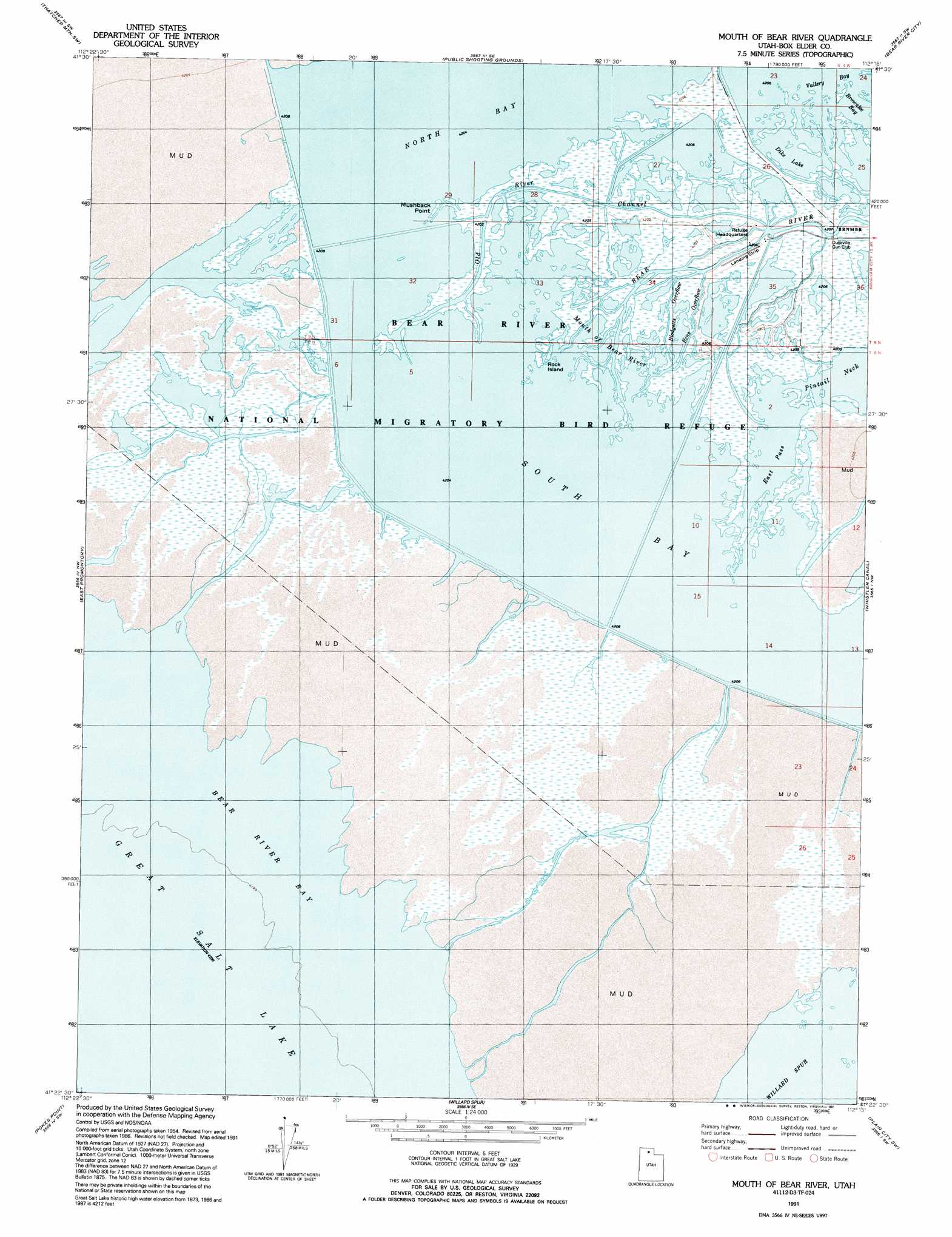
USGS Topo Quad 41112d3 - 1:24,000 scale
| Topo Map Name: | Mouth Of Bear River |
| USGS Topo Quad ID: | 41112d3 |
| Print Size: | ca. 21 1/4" wide x 27" high |
| Southeast Coordinates: | 41.375° N latitude / 112.25° W longitude |
| Map Center Coordinates: | 41.4375° N latitude / 112.3125° W longitude |
| U.S. State: | UT |
| Filename: | o41112d3.jpg |
| Download Map JPG Image: | Mouth Of Bear River topo map 1:24,000 scale |
| Map Type: | Topographic |
| Topo Series: | 7.5´ |
| Map Scale: | 1:24,000 |
| Source of Map Images: | United States Geological Survey (USGS) |
| Alternate Map Versions: |
Mouth of Bear River UT 1955, updated 1956 Download PDF Buy paper map Mouth of Bear River UT 1972, updated 1974 Download PDF Buy paper map Mouth of Bear River UT 1991, updated 1991 Download PDF Buy paper map Mouth of Bear River UT 2011 Download PDF Buy paper map Mouth of Bear River UT 2014 Download PDF Buy paper map |
1:24,000 Topo Quads surrounding Mouth Of Bear River
Sunset Pass |
Lampo Junction |
Thatcher Mountain |
Tremonton |
Honeyville |
Golden Spike Monument |
Thatcher Mountain Sw |
Public Shooting Grounds |
Bear River City |
Brigham City |
Messix Peak |
East Promontory |
Mouth Of Bear River |
Whistler Canal |
Willard |
Indian Cove |
Pokes Point |
Willard Spur |
Plain City Sw |
Plain City |
Carrington Island Ne |
Promontory Point |
Fremont Island |
Ogden Bay |
Roy |
> Back to 41112a1 at 1:100,000 scale
> Back to 41112a1 at 1:250,000 scale
> Back to U.S. Topo Maps home
Mouth Of Bear River topo map: Gazetteer
Mouth Of Bear River: Areas
Mouth of Bear River elevation 1281m 4202′Mouth Of Bear River: Bays
Brownlee Bay elevation 1281m 4202′Vallery Bay elevation 1282m 4206′
Mouth Of Bear River: Capes
Mushback Point elevation 1281m 4202′Pintail Neck elevation 1281m 4202′
Mouth Of Bear River: Channels
Bens Overflow elevation 1283m 4209′Blodgetts Overflow elevation 1281m 4202′
East Pass elevation 1281m 4202′
Old River Channel elevation 1281m 4202′
Mouth Of Bear River: Islands
Rock Island elevation 1281m 4202′Mouth Of Bear River: Lakes
Dike Lake elevation 1281m 4202′Mouth Of Bear River: Parks
Bear River Migratory Bird Refuge elevation 1282m 4206′Bear River National Migratory Bird Refuge (historical) elevation 1283m 4209′
Mouth Of Bear River: Reservoirs
North Bay elevation 1281m 4202′South Bay elevation 1281m 4202′
Mouth Of Bear River: Streams
Bear River elevation 1281m 4202′Mouth Of Bear River digital topo map on disk
Buy this Mouth Of Bear River topo map showing relief, roads, GPS coordinates and other geographical features, as a high-resolution digital map file on DVD: