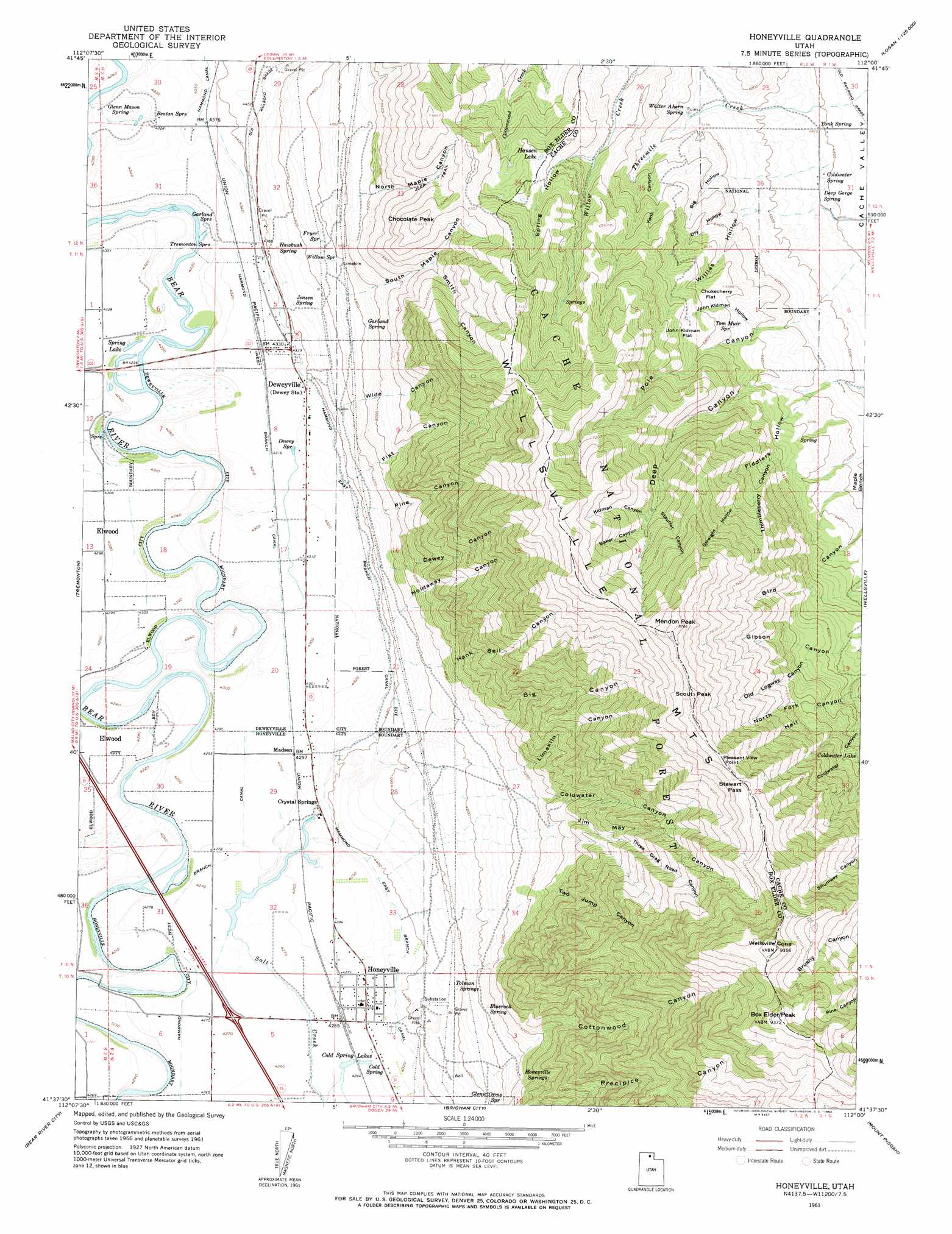
Honeyville Topo Map Utah
To zoom in, hover over the map of Honeyville
USGS Topo Quad 41112f1 - 1:24,000 scale
| Topo Map Name: | Honeyville |
| USGS Topo Quad ID: | 41112f1 |
| Print Size: | ca. 21 1/4" wide x 27" high |
| Southeast Coordinates: | 41.625° N latitude / 112° W longitude |
| Map Center Coordinates: | 41.6875° N latitude / 112.0625° W longitude |
| U.S. State: | UT |
| Filename: | o41112f1.jpg |
| Download Map JPG Image: | Honeyville topo map 1:24,000 scale |
| Map Type: | Topographic |
| Topo Series: | 7.5´ |
| Map Scale: | 1:24,000 |
| Source of Map Images: | United States Geological Survey (USGS) |
| Alternate Map Versions: |
Honeyville UT 1961, updated 1963 Download PDF Buy paper map Honeyville UT 1961, updated 1963 Download PDF Buy paper map Honeyville UT 1998, updated 2001 Download PDF Buy paper map Honeyville UT 2011 Download PDF Buy paper map Honeyville UT 2014 Download PDF Buy paper map |
| FStopo: | US Forest Service topo Honeyville is available: Download FStopo PDF Download FStopo TIF |
1:24,000 Topo Quads surrounding Honeyville
Limekiln Knoll |
Portage |
Clarkston |
Trenton |
Richmond |
Blind Springs |
Riverside |
Cutler Dam |
Newton |
Smithfield |
Thatcher Mountain |
Tremonton |
Honeyville |
Wellsville |
Logan |
Public Shooting Grounds |
Bear River City |
Brigham City |
Mount Pisgah |
Paradise |
Mouth Of Bear River |
Whistler Canal |
Willard |
Mantua |
James Peak |
> Back to 41112e1 at 1:100,000 scale
> Back to 41112a1 at 1:250,000 scale
> Back to U.S. Topo Maps home
Honeyville topo map: Gazetteer
Honeyville: Canals
Hammond East Branch Canal elevation 1333m 4373′Hammond West Branch Canal elevation 1301m 4268′
Honeyville: Cliffs
Pleasant View Point elevation 2590m 8497′Honeyville: Flats
Chokecherry Flat elevation 1742m 5715′John Kidman Flat elevation 1806m 5925′
Honeyville: Gaps
Stewart Pass elevation 2550m 8366′Honeyville: Lakes
Cold Spring Lakes elevation 1300m 4265′Coldwater Lake elevation 1917m 6289′
Hansen Lake elevation 1841m 6040′
Spring Lake elevation 1290m 4232′
Honeyville: Populated Places
Crystal Springs elevation 1309m 4294′Deweyville elevation 1322m 4337′
Honeyville elevation 1310m 4297′
Madsen elevation 1310m 4297′
Honeyville: Springs
Beaton Springs elevation 1318m 4324′Bluerock Spring elevation 1473m 4832′
Cold Spring elevation 1300m 4265′
Coldwater Spring elevation 1476m 4842′
Deep Gorge Spring elevation 1469m 4819′
Dewey Spring elevation 1318m 4324′
Fryer Spring elevation 1451m 4760′
Garland Spring elevation 1468m 4816′
Garland Springs elevation 1300m 4265′
Glenn Mason Spring elevation 1308m 4291′
Glenn Orms Spring elevation 1466m 4809′
Hawbush Spring elevation 1366m 4481′
Honeyville Springs elevation 1562m 5124′
Jensen Spring elevation 1368m 4488′
Tolman Springs elevation 1367m 4484′
Tom Muir Spring elevation 1701m 5580′
Tremonton Springs elevation 1302m 4271′
Walter Ahern Spring elevation 1566m 5137′
Willow Spring elevation 1457m 4780′
Yonk Spring elevation 1467m 4812′
Honeyville: Summits
Bob Stewart Peak elevation 2626m 8615′Box Elder Peak elevation 2855m 9366′
Chocolate Peak elevation 1977m 6486′
Mendon Peak elevation 2650m 8694′
Scout Peak elevation 2646m 8681′
Wellsville Cone elevation 2843m 9327′
Honeyville: Valleys
Baker Canyon elevation 2095m 6873′Big Canyon elevation 1523m 4996′
Big Hollow elevation 1562m 5124′
Coldwater Canyon elevation 1578m 5177′
Cottonwood Canyon elevation 1505m 4937′
Dewey Canyon elevation 1363m 4471′
Dry Hollow elevation 1552m 5091′
Fiddlers Hollow elevation 1580m 5183′
Flat Canyon elevation 1372m 4501′
Hank Bell Canyon elevation 1445m 4740′
Holdaway Canyon elevation 1400m 4593′
Jim May Canyon elevation 1611m 5285′
John Kidman Hollow elevation 1647m 5403′
Kidman Canyon elevation 2084m 6837′
North Fork Hell Canyon elevation 1929m 6328′
North Maple Canyon elevation 1569m 5147′
Old Logway Canyon elevation 1839m 6033′
Pine Canyon elevation 1370m 4494′
Smith Canyon elevation 1685m 5528′
South Maple Canyon elevation 1453m 4767′
Spring Hollow elevation 1726m 5662′
Stauffer Canyon elevation 2080m 6824′
Straight Hollow elevation 1927m 6322′
Three Drag Road Canyon elevation 1787m 5862′
Two Jump Canyon elevation 1549m 5082′
Wide Canyon elevation 1373m 4504′
Willies Hollow elevation 1501m 4924′
Yonk Canyon elevation 1611m 5285′
Honeyville digital topo map on disk
Buy this Honeyville topo map showing relief, roads, GPS coordinates and other geographical features, as a high-resolution digital map file on DVD: