Locomotive Springs Topo Map Utah
To zoom in, hover over the map of Locomotive Springs
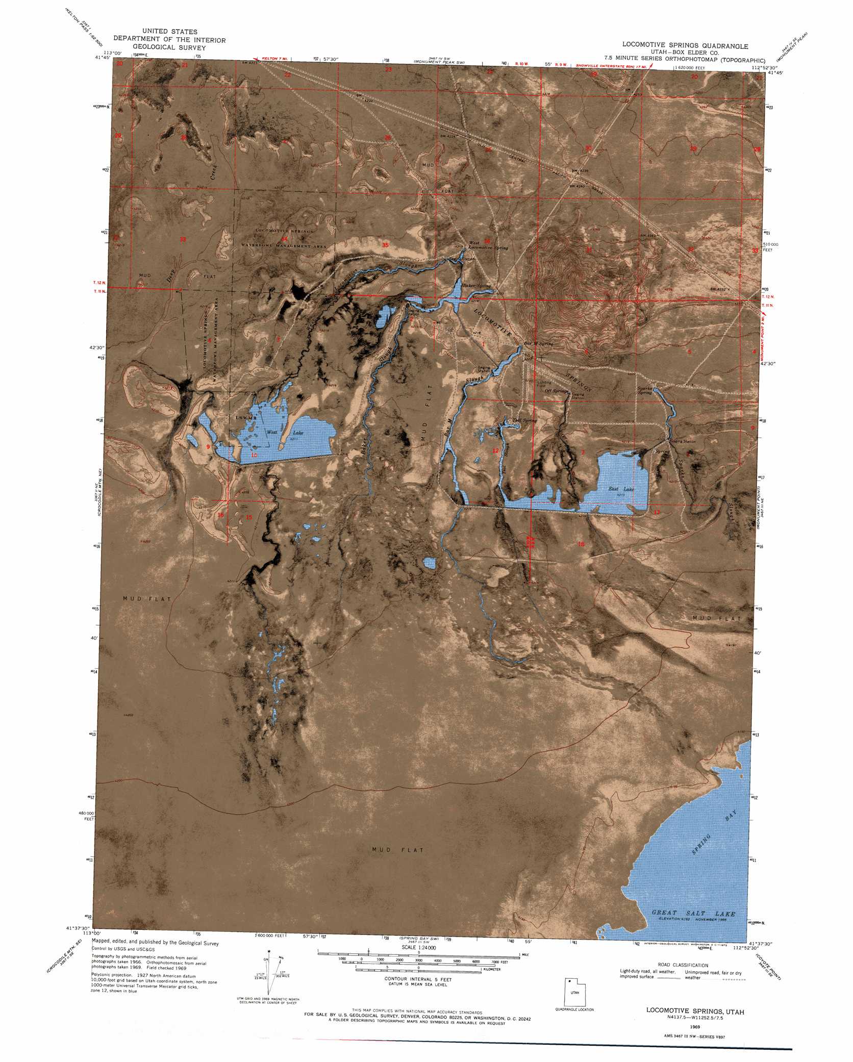
USGS Topo Quad 41112f8 - 1:24,000 scale
| Topo Map Name: | Locomotive Springs |
| USGS Topo Quad ID: | 41112f8 |
| Print Size: | ca. 21 1/4" wide x 27" high |
| Southeast Coordinates: | 41.625° N latitude / 112.875° W longitude |
| Map Center Coordinates: | 41.6875° N latitude / 112.9375° W longitude |
| U.S. State: | UT |
| Filename: | p41112f8.jpg |
| Download Map JPG Image: | Locomotive Springs topo map 1:24,000 scale |
| Map Type: | Orthophoto |
| Topo Series: | 7.5´ |
| Map Scale: | 1:24,000 |
| Source of Map Images: | United States Geological Survey (USGS) |
| Alternate Map Versions: |
Locomotive Springs UT 1969, updated 1972 Download PDF Buy paper map Locomotive Springs UT 2011 Download PDF Buy paper map Locomotive Springs UT 2014 Download PDF Buy paper map |
1:24,000 Topo Quads surrounding Locomotive Springs
Kelton Pass |
Curlew Junction |
Monument Peak Nw |
Monument Peak Ne |
Snowville |
Black Butte |
Kelton Pass Se |
Monument Peak Sw |
Monument Peak |
Salt Wells |
Peplin Flats |
Crocodile Mountain Ne |
Locomotive Springs |
Monument Point |
Lake Ridge |
Hogup Bar |
Crocodile Mountain Se |
Spring Bay Sw |
Coyote Point |
Rozel |
Tangent Peak |
Dolphin Island West |
Dolphin Island East |
Gunnison Island Ne |
Rozel Point |
> Back to 41112e1 at 1:100,000 scale
> Back to 41112a1 at 1:250,000 scale
> Back to U.S. Topo Maps home
Locomotive Springs topo map: Gazetteer
Locomotive Springs: Parks
Locomotive Springs Waterfowl Management Area elevation 1284m 4212′Locomotive Springs: Reservoirs
East Lake elevation 1284m 4212′West Lake elevation 1284m 4212′
Locomotive Springs: Springs
Baker Spring elevation 1288m 4225′Bar M Spring elevation 1288m 4225′
Locomotive Springs elevation 1288m 4225′
Off Spring elevation 1287m 4222′
Sparks Spring elevation 1287m 4222′
Teal Spring elevation 1286m 4219′
West Locomotive Spring elevation 1287m 4222′
Locomotive Springs: Streams
Baker Slough elevation 1283m 4209′Bar M Slough elevation 1282m 4206′
Deep Creek elevation 1283m 4209′
Deep Creek elevation 1283m 4209′
Off Slough elevation 1283m 4209′
Sparks Slough elevation 1282m 4206′
Teal Slough elevation 1282m 4206′
West Locomotive Slough elevation 1282m 4206′
Locomotive Springs: Summits
Indian Hill elevation 1324m 4343′Locomotive Springs digital topo map on disk
Buy this Locomotive Springs topo map showing relief, roads, GPS coordinates and other geographical features, as a high-resolution digital map file on DVD: