Rocky Pass Peak Topo Map Utah
To zoom in, hover over the map of Rocky Pass Peak
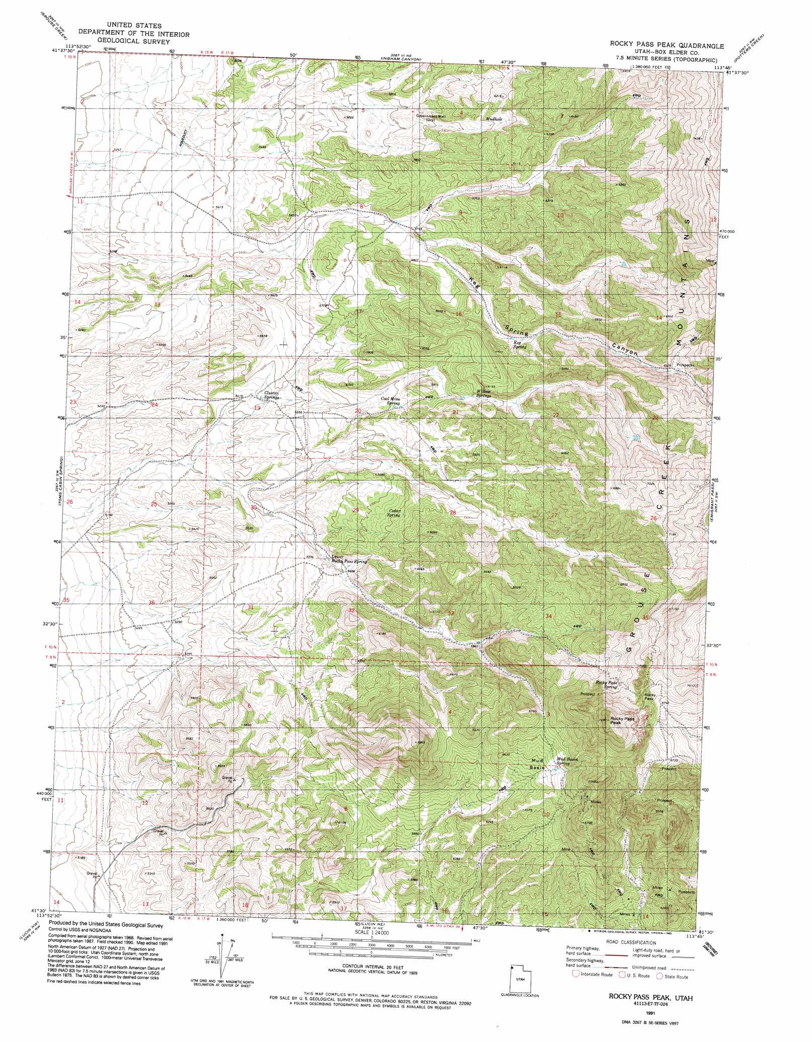
USGS Topo Quad 41113e7 - 1:24,000 scale
| Topo Map Name: | Rocky Pass Peak |
| USGS Topo Quad ID: | 41113e7 |
| Print Size: | ca. 21 1/4" wide x 27" high |
| Southeast Coordinates: | 41.5° N latitude / 113.75° W longitude |
| Map Center Coordinates: | 41.5625° N latitude / 113.8125° W longitude |
| U.S. State: | UT |
| Filename: | o41113e7.jpg |
| Download Map JPG Image: | Rocky Pass Peak topo map 1:24,000 scale |
| Map Type: | Topographic |
| Topo Series: | 7.5´ |
| Map Scale: | 1:24,000 |
| Source of Map Images: | United States Geological Survey (USGS) |
| Alternate Map Versions: |
Rocky Pass Peak UT 1971, updated 1974 Download PDF Buy paper map Rocky Pass Peak UT 1991, updated 1992 Download PDF Buy paper map Rocky Pass Peak UT 2011 Download PDF Buy paper map Rocky Pass Peak UT 2014 Download PDF Buy paper map |
1:24,000 Topo Quads surrounding Rocky Pass Peak
Judd Mountain |
Dry Canyon Mountain |
Kimbell Creek |
Lynn Reservoir |
Dennis Hill |
Death Creek Reservoir |
Grouse Creek |
Ingham Canyon |
Potters Creek |
Warm Spring Hills |
Dairy Valley |
Toms Cabin Spring |
Rocky Pass Peak |
Emigrant Pass |
Prohibition Spring |
Jackson Spring |
Lucin Nw |
Lucin Ne |
Bovine |
Terrace Mountain West |
Tecoma |
Lucin |
Pigeon Mountain |
Jackson |
Bovine Se |
> Back to 41113e1 at 1:100,000 scale
> Back to 41112a1 at 1:250,000 scale
> Back to U.S. Topo Maps home
Rocky Pass Peak topo map: Gazetteer
Rocky Pass Peak: Basins
Mud Basin elevation 1945m 6381′Rocky Pass Peak: Gaps
Rocky Pass elevation 2103m 6899′Rocky Pass Peak: Springs
Cedar Spring elevation 1781m 5843′Cluster Springs elevation 1662m 5452′
Coal Mine Spring elevation 1755m 5757′
Keg Spring elevation 1842m 6043′
Lower Rocky Pass Spring elevation 1696m 5564′
Mud Basin Spring elevation 1968m 6456′
Rocky Pass Spring elevation 2069m 6788′
Willow Springs elevation 1819m 5967′
Rocky Pass Peak: Summits
Rocky Pass Peak elevation 2279m 7477′Rocky Pass Peak: Valleys
Keg Spring Canyon elevation 1665m 5462′Rocky Pass Peak: Wells
Government Well elevation 1760m 5774′Rocky Pass Peak digital topo map on disk
Buy this Rocky Pass Peak topo map showing relief, roads, GPS coordinates and other geographical features, as a high-resolution digital map file on DVD: