Patterson Pass Topo Map Nevada
To zoom in, hover over the map of Patterson Pass
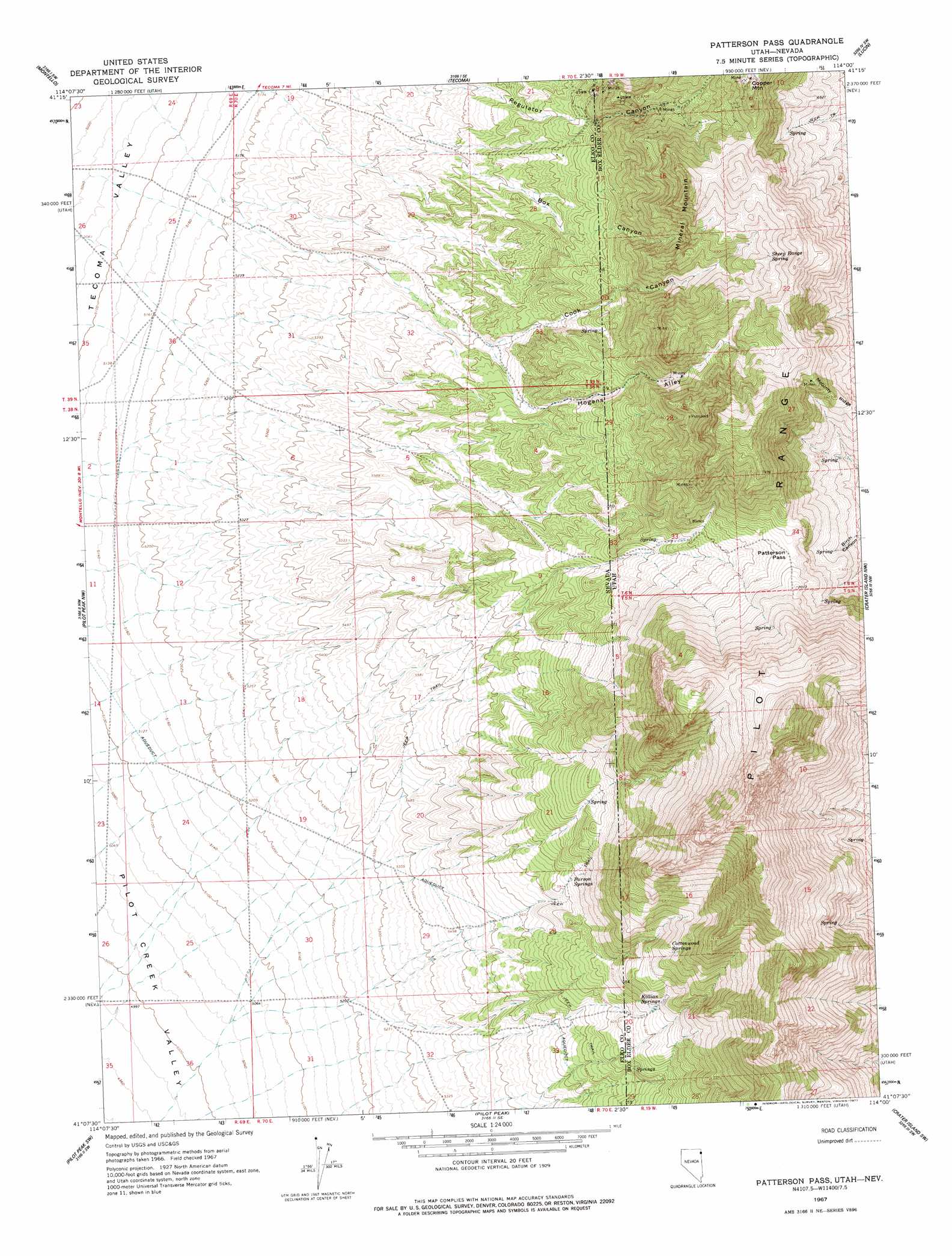
USGS Topo Quad 41114b1 - 1:24,000 scale
| Topo Map Name: | Patterson Pass |
| USGS Topo Quad ID: | 41114b1 |
| Print Size: | ca. 21 1/4" wide x 27" high |
| Southeast Coordinates: | 41.125° N latitude / 114° W longitude |
| Map Center Coordinates: | 41.1875° N latitude / 114.0625° W longitude |
| U.S. States: | NV, UT |
| Filename: | o41114b1.jpg |
| Download Map JPG Image: | Patterson Pass topo map 1:24,000 scale |
| Map Type: | Topographic |
| Topo Series: | 7.5´ |
| Map Scale: | 1:24,000 |
| Source of Map Images: | United States Geological Survey (USGS) |
| Alternate Map Versions: |
Patterson Pass UT 1967, updated 1971 Download PDF Buy paper map Patterson Pass UT 1967, updated 1977 Download PDF Buy paper map Patterson Pass UT 2011 Download PDF Buy paper map Patterson Pass UT 2014 Download PDF Buy paper map Patterson Pass UT 2017 Download PDF Buy paper map |
1:24,000 Topo Quads surrounding Patterson Pass
Ninemile Mountain Ne |
Twelvemile Ranch |
Jackson Spring |
Lucin Nw |
Lucin Ne |
Montello Canyon |
Montello |
Tecoma |
Lucin |
Pigeon Mountain |
Loray |
Pilot Peak Nw |
Patterson Pass |
Crater Island Nw |
Lemay Island |
Cobre Se |
Pilot Peak Sw |
Pilot Peak |
Crater Island Sw |
Crater Island |
Silver Zone Pass |
Leppy Peak Nw |
Miners Canyon |
Silver Island Pass |
Graham Peak |
> Back to 41114a1 at 1:100,000 scale
> Back to 41114a1 at 1:250,000 scale
> Back to U.S. Topo Maps home
Patterson Pass topo map: Gazetteer
Patterson Pass: Gaps
Patterson Pass elevation 2092m 6863′Patterson Pass: Ridges
McGinty Ridge elevation 2073m 6801′Patterson Pass: Springs
Cottonwood Springs elevation 2052m 6732′Killian Springs elevation 1886m 6187′
Parson Springs elevation 1819m 5967′
Sheep Range Spring elevation 2183m 7162′
Patterson Pass: Summits
Copper Mountain elevation 2242m 7355′Mineral Mountain elevation 2125m 6971′
Patterson Pass: Valleys
Box Canyon elevation 1643m 5390′Box Canyon elevation 1588m 5209′
Cook Canyon elevation 1584m 5196′
Cook Canyon elevation 1727m 5666′
Hogans Alley elevation 1726m 5662′
Hogans Alley elevation 1568m 5144′
Patterson Gulch elevation 1524m 5000′
Patterson Pass digital topo map on disk
Buy this Patterson Pass topo map showing relief, roads, GPS coordinates and other geographical features, as a high-resolution digital map file on DVD: