Montello Topo Map Nevada
To zoom in, hover over the map of Montello
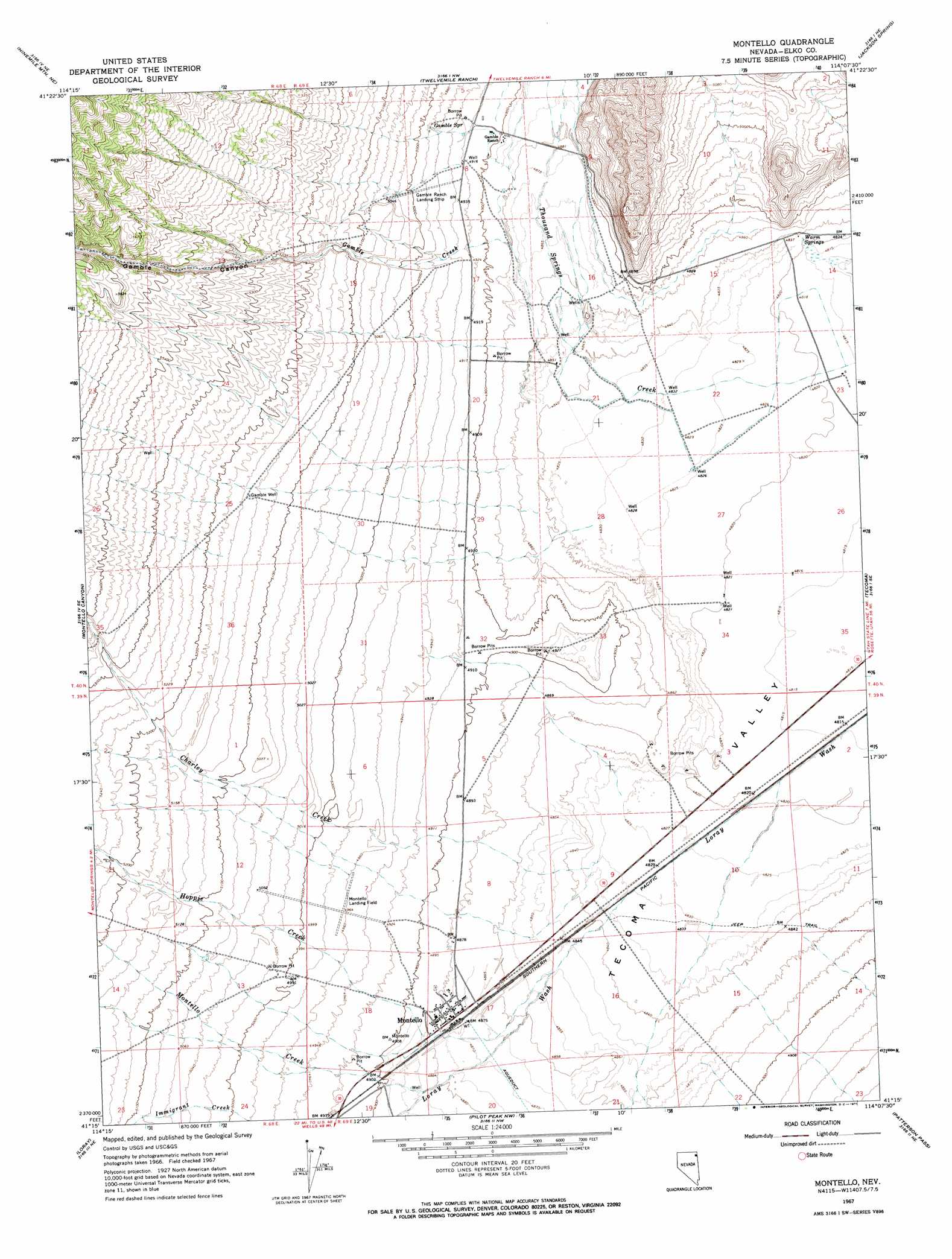
USGS Topo Quad 41114c2 - 1:24,000 scale
| Topo Map Name: | Montello |
| USGS Topo Quad ID: | 41114c2 |
| Print Size: | ca. 21 1/4" wide x 27" high |
| Southeast Coordinates: | 41.25° N latitude / 114.125° W longitude |
| Map Center Coordinates: | 41.3125° N latitude / 114.1875° W longitude |
| U.S. State: | NV |
| Filename: | o41114c2.jpg |
| Download Map JPG Image: | Montello topo map 1:24,000 scale |
| Map Type: | Topographic |
| Topo Series: | 7.5´ |
| Map Scale: | 1:24,000 |
| Source of Map Images: | United States Geological Survey (USGS) |
| Alternate Map Versions: |
Montello NV 1967, updated 1971 Download PDF Buy paper map Montello NV 2012 Download PDF Buy paper map Montello NV 2014 Download PDF Buy paper map |
1:24,000 Topo Quads surrounding Montello
Chicken Springs |
Delano Peak |
Crittenden Springs |
Dairy Valley |
Toms Cabin Spring |
Ninemile Mountain |
Ninemile Mountain Ne |
Twelvemile Ranch |
Jackson Spring |
Lucin Nw |
Ninemile Mountain Sw |
Montello Canyon |
Montello |
Tecoma |
Lucin |
Valley Pass |
Loray |
Pilot Peak Nw |
Patterson Pass |
Crater Island Nw |
Cobre |
Cobre Se |
Pilot Peak Sw |
Pilot Peak |
Crater Island Sw |
> Back to 41114a1 at 1:100,000 scale
> Back to 41114a1 at 1:250,000 scale
> Back to U.S. Topo Maps home
Montello topo map: Gazetteer
Montello: Airports
Gamble Ranch Landing Strip elevation 1520m 4986′Montello Landing Strip elevation 1518m 4980′
Montello: Populated Places
Montello elevation 1487m 4878′Montello: Post Offices
Montello Post Office elevation 1487m 4878′Montello: Springs
Gamble Spring elevation 1523m 4996′Warm Springs elevation 1473m 4832′
Montello: Streams
Charley Creek elevation 1473m 4832′Gamble Creek elevation 1481m 4858′
Hoppie Creek elevation 1489m 4885′
Montello Creek elevation 1488m 4881′
Montello: Valleys
Gamble Canyon elevation 1490m 4888′Montello: Wells
Gamble Well elevation 1572m 5157′Montello digital topo map on disk
Buy this Montello topo map showing relief, roads, GPS coordinates and other geographical features, as a high-resolution digital map file on DVD: