Coal Mine Basin Topo Map Nevada
To zoom in, hover over the map of Coal Mine Basin
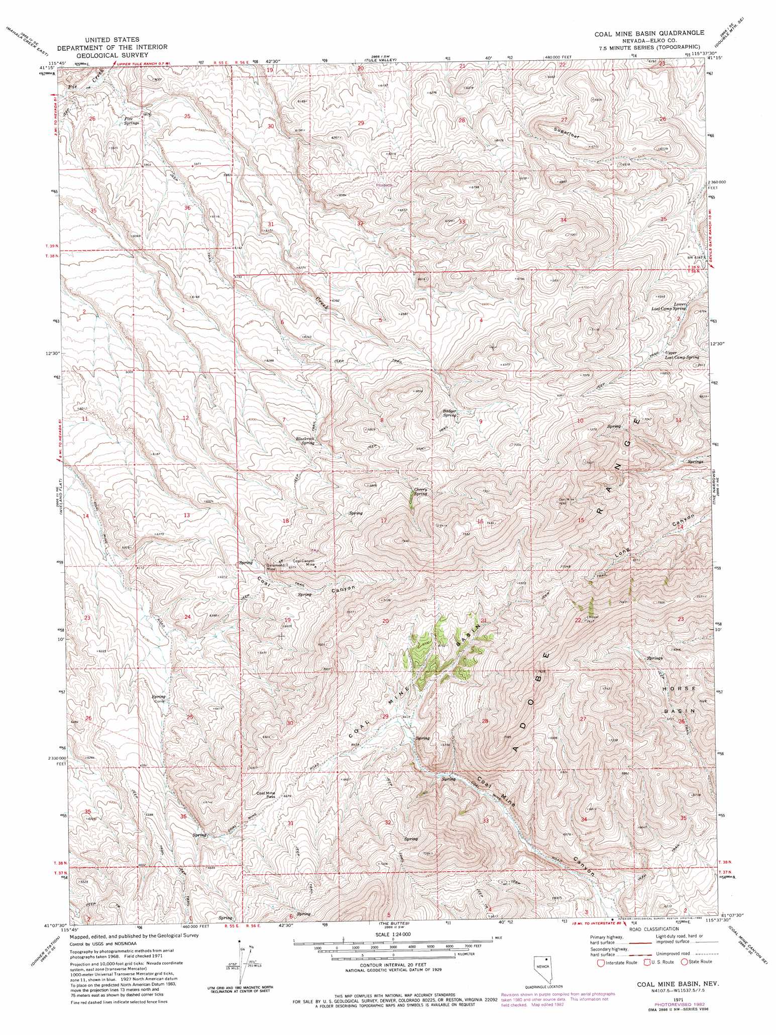
USGS Topo Quad 41115b6 - 1:24,000 scale
| Topo Map Name: | Coal Mine Basin |
| USGS Topo Quad ID: | 41115b6 |
| Print Size: | ca. 21 1/4" wide x 27" high |
| Southeast Coordinates: | 41.125° N latitude / 115.625° W longitude |
| Map Center Coordinates: | 41.1875° N latitude / 115.6875° W longitude |
| U.S. State: | NV |
| Filename: | o41115b6.jpg |
| Download Map JPG Image: | Coal Mine Basin topo map 1:24,000 scale |
| Map Type: | Topographic |
| Topo Series: | 7.5´ |
| Map Scale: | 1:24,000 |
| Source of Map Images: | United States Geological Survey (USGS) |
| Alternate Map Versions: |
Coal Mine Basin NV 1971, updated 1974 Download PDF Buy paper map Coal Mine Basin NV 1971, updated 1983 Download PDF Buy paper map Coal Mine Basin NV 2012 Download PDF Buy paper map Coal Mine Basin NV 2014 Download PDF Buy paper map |
1:24,000 Topo Quads surrounding Coal Mine Basin
California Mountain |
North Fork |
Double Mountain |
Devils Armchair |
Stag Mountain |
Mahala Creek West |
Mahala Creek East |
Tule Valley |
Double Mountain Se |
Hanks Creek Sw |
Reed Station |
Wieland Flat |
Coal Mine Basin |
The Narrows |
Peko Peak |
Singletree Creek |
Dinner Station |
The Buttes |
Coal Mine Canyon Se |
Morgan Hill |
Adobe Summit |
Kittridge Springs |
Osino |
Ryndon |
Halleck |
> Back to 41115a1 at 1:100,000 scale
> Back to 41114a1 at 1:250,000 scale
> Back to U.S. Topo Maps home
Coal Mine Basin topo map: Gazetteer
Coal Mine Basin: Basins
Coal Mine Basin elevation 1960m 6430′Coal Mine Basin: Gaps
Coal Mine Pass elevation 2037m 6683′Coal Mine Basin: Mines
Coal Canyon Mine elevation 2096m 6876′Garamendi Mine elevation 1949m 6394′
Coal Mine Basin: Springs
Badger Spring elevation 2043m 6702′Blackrock Spring elevation 1949m 6394′
Cherry Spring elevation 2083m 6833′
Five Springs elevation 1775m 5823′
Lower Lost Camp Spring elevation 1986m 6515′
Upper Lost Camp Spring elevation 2024m 6640′
Coal Mine Basin: Streams
Badger Creek elevation 1750m 5741′Coal Mine Basin: Summits
Sugarloaf elevation 2057m 6748′Tower Mountain elevation 2345m 7693′
Coal Mine Basin: Valleys
Coal Canyon elevation 1833m 6013′Coal Mine Basin digital topo map on disk
Buy this Coal Mine Basin topo map showing relief, roads, GPS coordinates and other geographical features, as a high-resolution digital map file on DVD: