Gilmer Ranch Topo Map Nevada
To zoom in, hover over the map of Gilmer Ranch
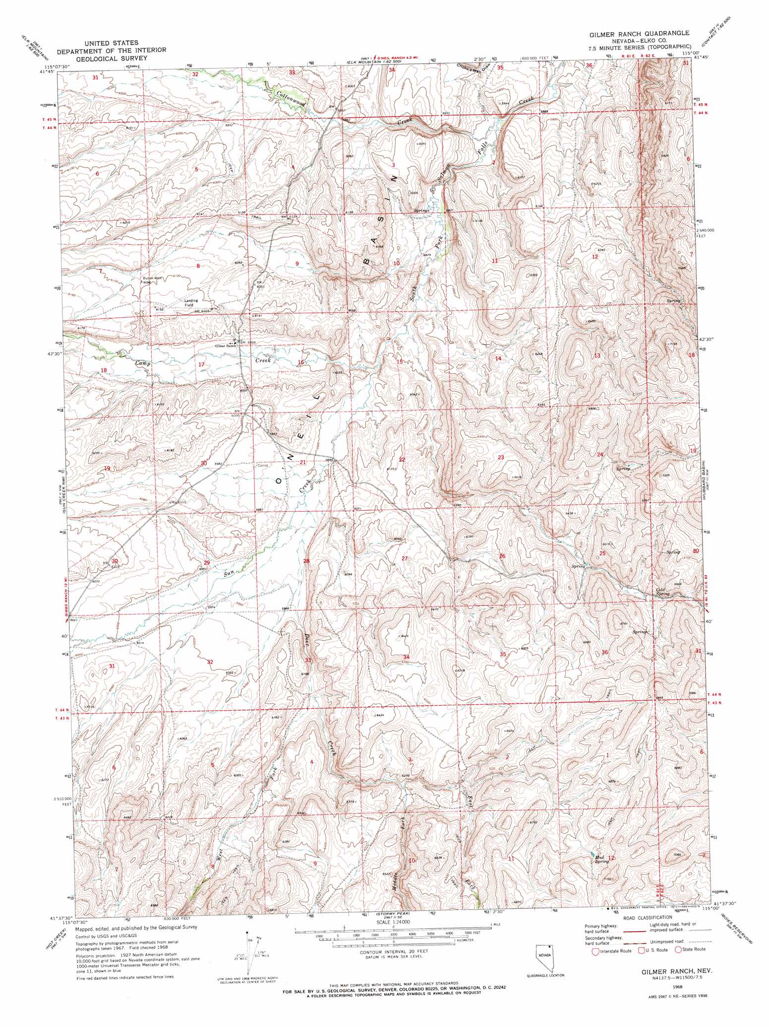
USGS Topo Quad 41115f1 - 1:24,000 scale
| Topo Map Name: | Gilmer Ranch |
| USGS Topo Quad ID: | 41115f1 |
| Print Size: | ca. 21 1/4" wide x 27" high |
| Southeast Coordinates: | 41.625° N latitude / 115° W longitude |
| Map Center Coordinates: | 41.6875° N latitude / 115.0625° W longitude |
| U.S. State: | NV |
| Filename: | o41115f1.jpg |
| Download Map JPG Image: | Gilmer Ranch topo map 1:24,000 scale |
| Map Type: | Topographic |
| Topo Series: | 7.5´ |
| Map Scale: | 1:24,000 |
| Source of Map Images: | United States Geological Survey (USGS) |
| Alternate Map Versions: |
Gilmer Ranch NV 1968, updated 1973 Download PDF Buy paper map Gilmer Ranch NV 2012 Download PDF Buy paper map Gilmer Ranch NV 2015 Download PDF Buy paper map |
1:24,000 Topo Quads surrounding Gilmer Ranch
Robinson Creek |
Caudle Creek |
Elk Mountain |
Bear Mountain |
Browns Bench Ranch |
Gods Pocket Peak |
Goat Creek |
Buckhorn Ridge |
Twin Meadows Ranch |
Contact |
Marys River Basin Ne |
Sun Creek Nw |
Gilmer Ranch |
Hubbard Basin |
Henry |
Marys River Basin Se |
Hot Creek |
Stormy Peak |
Boies Reservoir |
Harris Canyon |
Hanks Creek Ne |
Buena Vista Ranch |
Black Butte Ne |
Loomis Mountain |
Wilkins |
> Back to 41115e1 at 1:100,000 scale
> Back to 41114a1 at 1:250,000 scale
> Back to U.S. Topo Maps home
Gilmer Ranch topo map: Gazetteer
Gilmer Ranch: Populated Places
Morlan (historical) elevation 1817m 5961′Gilmer Ranch: Springs
Cold Spring elevation 1959m 6427′Mud Spring elevation 2065m 6774′
Gilmer Ranch: Streams
Camp Creek elevation 1788m 5866′Can Creek elevation 1803m 5915′
Cottonwood Creek elevation 1763m 5784′
Deer Creek elevation 1801m 5908′
East Fork Deer Creek elevation 1884m 6181′
Middle Fork Deer Creek elevation 1885m 6184′
Sun Creek elevation 1792m 5879′
West Fork Deer Creek elevation 1833m 6013′
Gilmer Ranch: Wells
Butler Well elevation 1855m 6085′Gilmer Ranch digital topo map on disk
Buy this Gilmer Ranch topo map showing relief, roads, GPS coordinates and other geographical features, as a high-resolution digital map file on DVD: