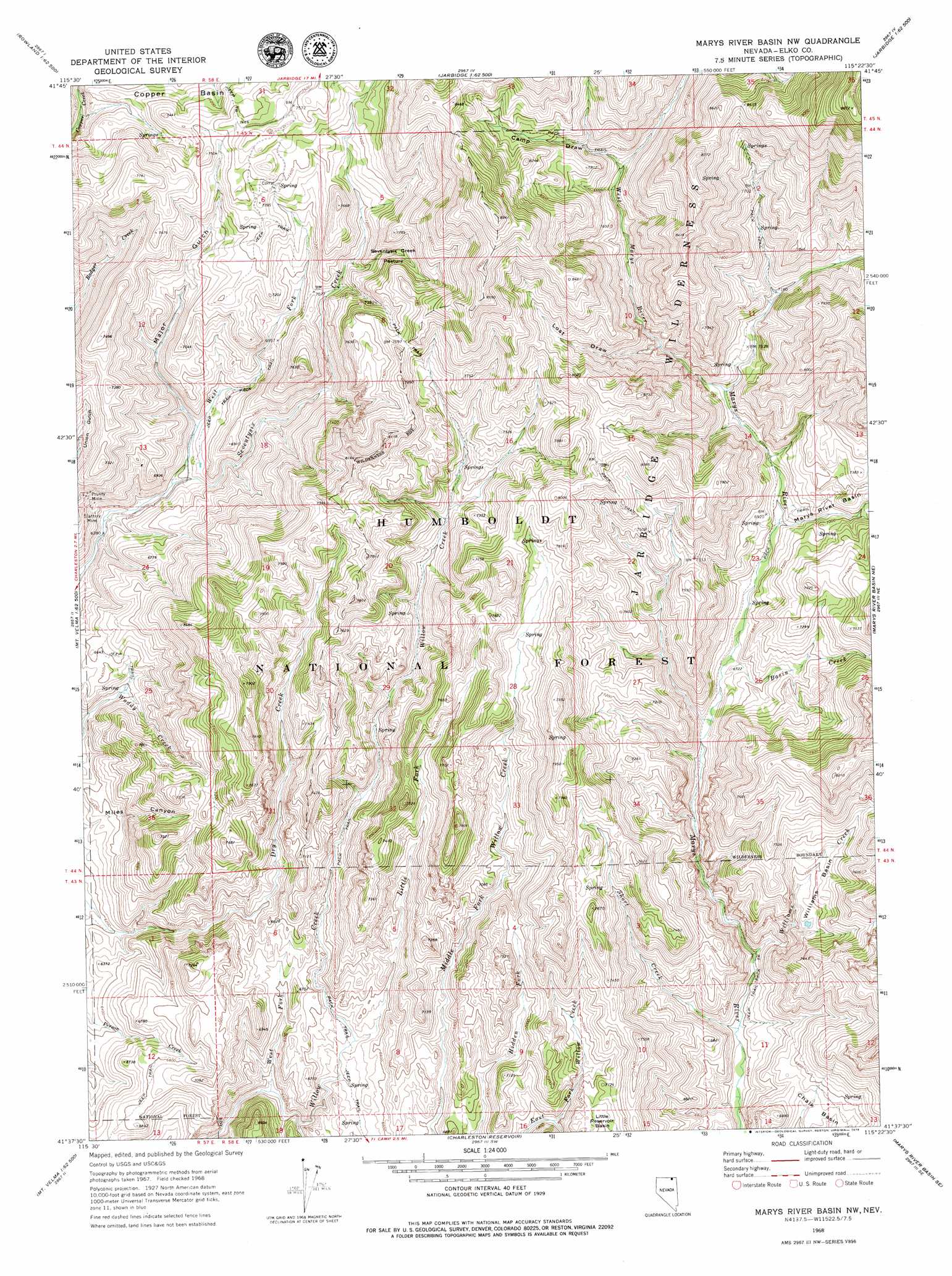
Marys River Basin Nw Topo Map Nevada
To zoom in, hover over the map of Marys River Basin Nw
USGS Topo Quad 41115f4 - 1:24,000 scale
| Topo Map Name: | Marys River Basin Nw |
| USGS Topo Quad ID: | 41115f4 |
| Print Size: | ca. 21 1/4" wide x 27" high |
| Southeast Coordinates: | 41.625° N latitude / 115.375° W longitude |
| Map Center Coordinates: | 41.6875° N latitude / 115.4375° W longitude |
| U.S. State: | NV |
| Filename: | o41115f4.jpg |
| Download Map JPG Image: | Marys River Basin Nw topo map 1:24,000 scale |
| Map Type: | Topographic |
| Topo Series: | 7.5´ |
| Map Scale: | 1:24,000 |
| Source of Map Images: | United States Geological Survey (USGS) |
| Alternate Map Versions: |
Marys River Basin NW NV 1968, updated 1972 Download PDF Buy paper map Marys River Basin NW NV 1968, updated 1979 Download PDF Buy paper map Marys River Basin NW NV 2012 Download PDF Buy paper map Marys River Basin NW NV 2015 Download PDF Buy paper map |
| FStopo: | US Forest Service topo Marys River Basin NW is available: Download FStopo PDF Download FStopo TIF |
1:24,000 Topo Quads surrounding Marys River Basin Nw
Big Table |
Bearpaw Mountain |
Jarbidge North |
Robinson Creek |
Caudle Creek |
Tennessee Mountain |
Coon Creek |
Jarbidge South |
Gods Pocket Peak |
Goat Creek |
Cornwall Mountain |
Annie Creek |
Marys River Basin Nw |
Marys River Basin Ne |
Sun Creek Nw |
Wagon Springs |
Mount Ichabod |
Charleston Reservoir |
Marys River Basin Se |
Hot Creek |
Double Mountain |
Devils Armchair |
Stag Mountain |
Hanks Creek Ne |
Buena Vista Ranch |
> Back to 41115e1 at 1:100,000 scale
> Back to 41114a1 at 1:250,000 scale
> Back to U.S. Topo Maps home
Marys River Basin Nw topo map: Gazetteer
Marys River Basin Nw: Basins
Williams Basin elevation 2120m 6955′Marys River Basin Nw: Flats
Seventysix Creek Pasture elevation 2246m 7368′Marys River Basin Nw: Mines
Prunty Mine elevation 2027m 6650′Slattery Mine elevation 1968m 6456′
Marys River Basin Nw: Ranges
Fox Creek Range elevation 2132m 6994′Marys River Basin Nw: Springs
Mud Spring elevation 2243m 7358′Marys River Basin Nw: Streams
Basin Creek elevation 2035m 6676′East Fork Marys River elevation 2070m 6791′
Little Fork Willow Creek elevation 1975m 6479′
Middle Fork Willow Creek elevation 1941m 6368′
Short Creek elevation 1947m 6387′
West Fork Seventysix Creek elevation 1948m 6391′
West Fork Willow Creek elevation 1936m 6351′
West Marys River elevation 2120m 6955′
Williams Creek elevation 1961m 6433′
Marys River Basin Nw: Valleys
Camp Draw elevation 2274m 7460′Lost Draw elevation 2188m 7178′
Major Gulch elevation 1974m 6476′
Marys River Basin Nw digital topo map on disk
Buy this Marys River Basin Nw topo map showing relief, roads, GPS coordinates and other geographical features, as a high-resolution digital map file on DVD: