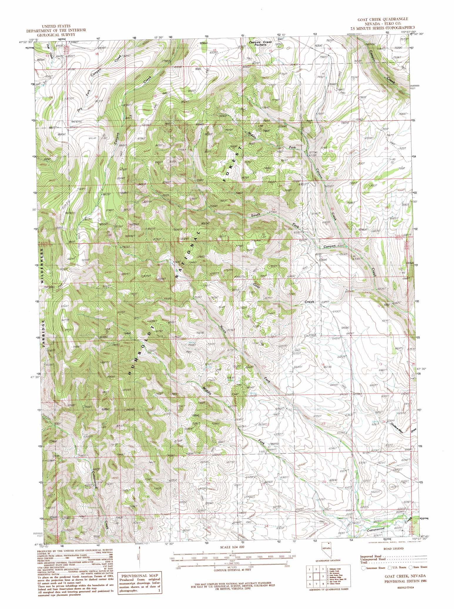
Goat Creek Topo Map Nevada
To zoom in, hover over the map of Goat Creek
USGS Topo Quad 41115g2 - 1:24,000 scale
| Topo Map Name: | Goat Creek |
| USGS Topo Quad ID: | 41115g2 |
| Print Size: | ca. 21 1/4" wide x 27" high |
| Southeast Coordinates: | 41.75° N latitude / 115.125° W longitude |
| Map Center Coordinates: | 41.8125° N latitude / 115.1875° W longitude |
| U.S. State: | NV |
| Filename: | o41115g2.jpg |
| Download Map JPG Image: | Goat Creek topo map 1:24,000 scale |
| Map Type: | Topographic |
| Topo Series: | 7.5´ |
| Map Scale: | 1:24,000 |
| Source of Map Images: | United States Geological Survey (USGS) |
| Alternate Map Versions: |
Goat Creek NV 1986, updated 1987 Download PDF Buy paper map Goat Creek NV 2012 Download PDF Buy paper map Goat Creek NV 2014 Download PDF Buy paper map |
| FStopo: | US Forest Service topo Goat Creek is available: Download FStopo PDF Download FStopo TIF |
1:24,000 Topo Quads surrounding Goat Creek
Dishpan |
Murphy Hot Springs |
Three Creek |
Curtis Draw |
Taylor Canyon |
Jarbidge North |
Robinson Creek |
Caudle Creek |
Elk Mountain |
Bear Mountain |
Jarbidge South |
Gods Pocket Peak |
Goat Creek |
Buckhorn Ridge |
Twin Meadows Ranch |
Marys River Basin Nw |
Marys River Basin Ne |
Sun Creek Nw |
Gilmer Ranch |
Hubbard Basin |
Charleston Reservoir |
Marys River Basin Se |
Hot Creek |
Stormy Peak |
Boies Reservoir |
> Back to 41115e1 at 1:100,000 scale
> Back to 41114a1 at 1:250,000 scale
> Back to U.S. Topo Maps home
Goat Creek topo map: Gazetteer
Goat Creek: Flats
Jaboonek Flat elevation 1927m 6322′Goat Creek: Streams
Goat Creek elevation 1914m 6279′Middle Fork Canyon Creek elevation 1942m 6371′
Middle Fork Cottonwood Creek elevation 1853m 6079′
North Fork Cottonwood Creek elevation 1842m 6043′
South Fork Canyon Creek elevation 1857m 6092′
Goat Creek digital topo map on disk
Buy this Goat Creek topo map showing relief, roads, GPS coordinates and other geographical features, as a high-resolution digital map file on DVD: