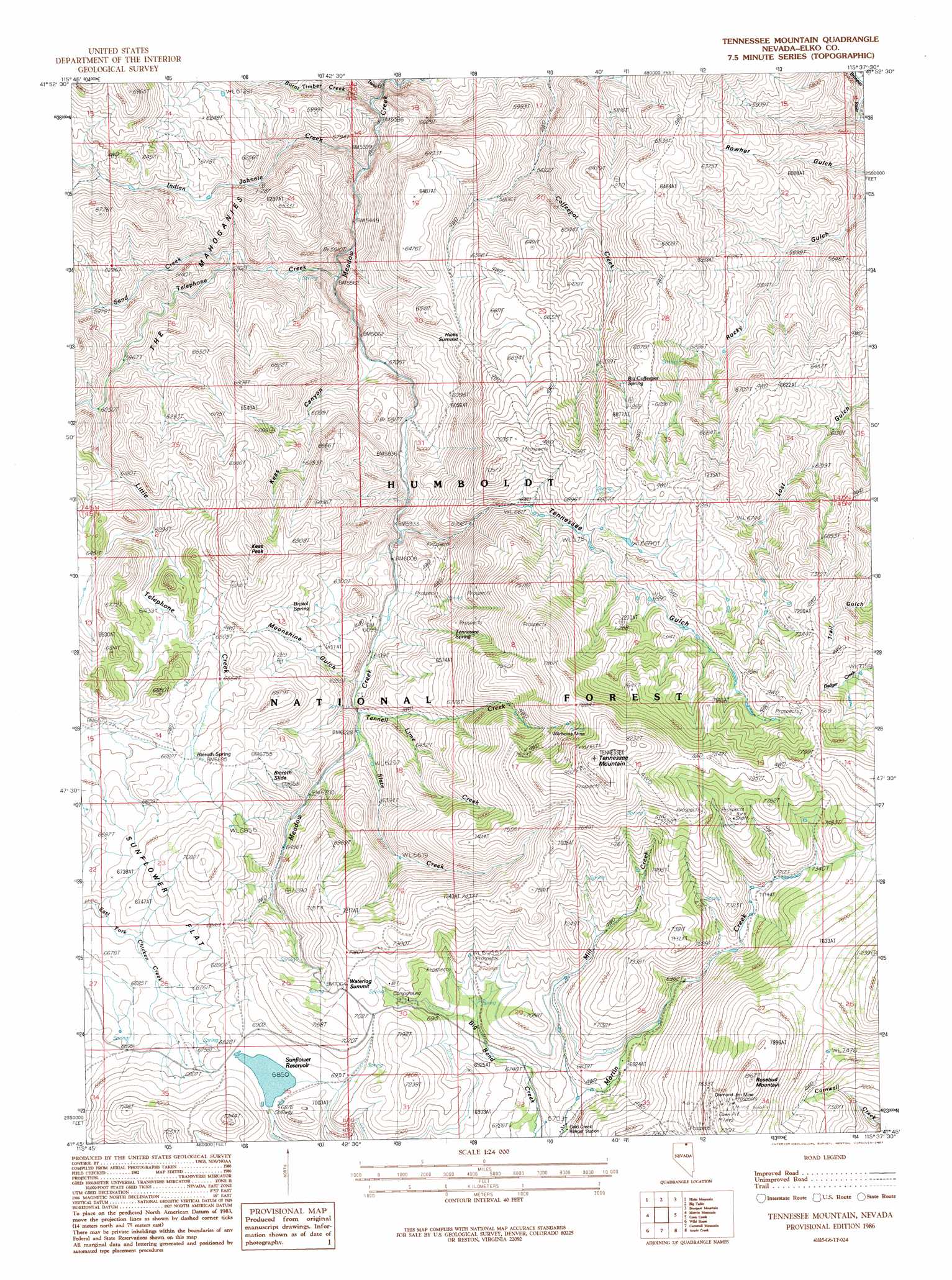
Tennessee Mountain Topo Map Nevada
To zoom in, hover over the map of Tennessee Mountain
USGS Topo Quad 41115g6 - 1:24,000 scale
| Topo Map Name: | Tennessee Mountain |
| USGS Topo Quad ID: | 41115g6 |
| Print Size: | ca. 21 1/4" wide x 27" high |
| Southeast Coordinates: | 41.75° N latitude / 115.625° W longitude |
| Map Center Coordinates: | 41.8125° N latitude / 115.6875° W longitude |
| U.S. State: | NV |
| Filename: | o41115g6.jpg |
| Download Map JPG Image: | Tennessee Mountain topo map 1:24,000 scale |
| Map Type: | Topographic |
| Topo Series: | 7.5´ |
| Map Scale: | 1:24,000 |
| Source of Map Images: | United States Geological Survey (USGS) |
| Alternate Map Versions: |
Tennessee Mountain NV 1986, updated 1987 Download PDF Buy paper map Tennessee Mountain NV 2012 Download PDF Buy paper map Tennessee Mountain NV 2015 Download PDF Buy paper map |
| FStopo: | US Forest Service topo Tennessee Mountain is available: Download FStopo PDF Download FStopo TIF |
1:24,000 Topo Quads surrounding Tennessee Mountain
Indian Hay Meadows |
Black Leg Creek |
Triplet Butte |
Cowan Reservoir |
Dishpan |
Winter Ridge |
Hicks Mountain |
Big Table |
Bearpaw Mountain |
Jarbidge North |
Mountain City |
Merritt Mountain |
Tennessee Mountain |
Coon Creek |
Jarbidge South |
Badger Creek |
Wild Horse |
Cornwall Mountain |
Annie Creek |
Marys River Basin Nw |
Mcafee Peak |
Delaware Creek |
Wagon Springs |
Mount Ichabod |
Charleston Reservoir |
> Back to 41115e1 at 1:100,000 scale
> Back to 41114a1 at 1:250,000 scale
> Back to U.S. Topo Maps home
Tennessee Mountain topo map: Gazetteer
Tennessee Mountain: Dams
Sunflower Dam elevation 2092m 6863′Tennessee Mountain: Mines
Diamond Jim Mine elevation 2351m 7713′Wildhorse Mine elevation 2280m 7480′
Tennessee Mountain: Ranges
The Mahoganies elevation 2063m 6768′Tennessee Mountain: Reservoirs
Sunflower Reservoir elevation 2092m 6863′Tennessee Mountain: Slopes
Bieroth Slide elevation 2029m 6656′Tennessee Mountain: Springs
Bieroth Spring elevation 2036m 6679′Big Coffeepot Spring elevation 2029m 6656′
Bristol Spring elevation 1981m 6499′
Tennessee Spring elevation 2040m 6692′
Tennessee Mountain: Streams
Burnt Timber Creek elevation 1659m 5442′Indian Johnnie Creek elevation 1706m 5597′
Lime Creek elevation 1938m 6358′
Little Telephone Creek elevation 1854m 6082′
Mill Creek elevation 2055m 6742′
Sand Creek elevation 1749m 5738′
Slate Creek elevation 1906m 6253′
Taylor Creek elevation 1698m 5570′
Telephone Creek elevation 1717m 5633′
Tennell Creek elevation 1898m 6227′
Tennessee Creek elevation 1814m 5951′
Tennessee Mountain: Summits
Hicks Summit elevation 2009m 6591′Keas Peak elevation 2181m 7155′
Rosebud Mountain elevation 2480m 8136′
Tennessee Mountain elevation 2535m 8316′
Waterlog Summit elevation 2152m 7060′
Tennessee Mountain: Valleys
Keas Canyon elevation 1743m 5718′Martin Canyon elevation 2062m 6765′
Moonshine Gulch elevation 1888m 6194′
Tennessee Gulch elevation 1824m 5984′
Tennessee Mountain digital topo map on disk
Buy this Tennessee Mountain topo map showing relief, roads, GPS coordinates and other geographical features, as a high-resolution digital map file on DVD: