Big Table Topo Map Nevada
To zoom in, hover over the map of Big Table
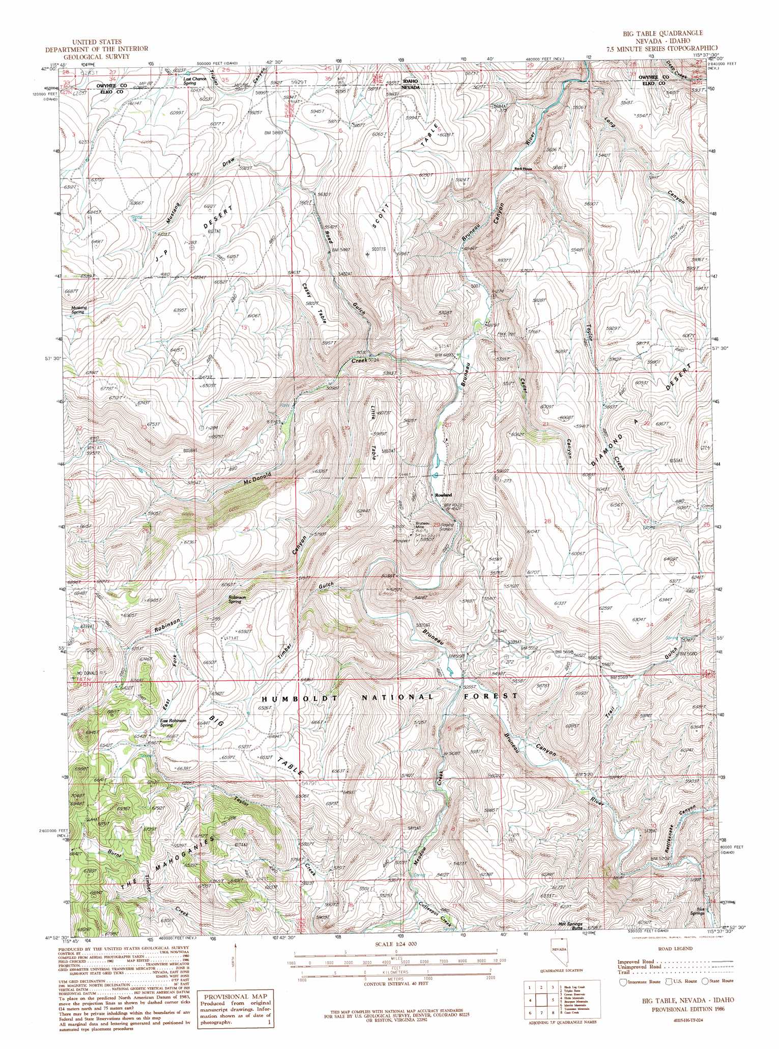
USGS Topo Quad 41115h6 - 1:24,000 scale
| Topo Map Name: | Big Table |
| USGS Topo Quad ID: | 41115h6 |
| Print Size: | ca. 21 1/4" wide x 27" high |
| Southeast Coordinates: | 41.875° N latitude / 115.625° W longitude |
| Map Center Coordinates: | 41.9375° N latitude / 115.6875° W longitude |
| U.S. States: | NV, ID |
| Filename: | o41115h6.jpg |
| Download Map JPG Image: | Big Table topo map 1:24,000 scale |
| Map Type: | Topographic |
| Topo Series: | 7.5´ |
| Map Scale: | 1:24,000 |
| Source of Map Images: | United States Geological Survey (USGS) |
| Alternate Map Versions: |
Big Table ID 1986, updated 1987 Download PDF Buy paper map Big Table ID 2012 Download PDF Buy paper map Big Table ID 2013 Download PDF Buy paper map |
| FStopo: | US Forest Service topo Big Table is available: Download FStopo PDF Download FStopo TIF |
1:24,000 Topo Quads surrounding Big Table
Buckhorn |
Antelope Creek |
Triguero Lake |
The Arch |
Poison Butte |
Indian Hay Meadows |
Black Leg Creek |
Triplet Butte |
Cowan Reservoir |
Dishpan |
Winter Ridge |
Hicks Mountain |
Big Table |
Bearpaw Mountain |
Jarbidge North |
Mountain City |
Merritt Mountain |
Tennessee Mountain |
Coon Creek |
Jarbidge South |
Badger Creek |
Wild Horse |
Cornwall Mountain |
Annie Creek |
Marys River Basin Nw |
> Back to 41115e1 at 1:100,000 scale
> Back to 41114a1 at 1:250,000 scale
> Back to U.S. Topo Maps home
Big Table topo map: Gazetteer
Big Table: Basins
Taylor Pocket elevation 1862m 6108′Big Table: Flats
Big Table elevation 1993m 6538′J-P Desert elevation 1790m 5872′
Scott Table elevation 1839m 6033′
Big Table: Mines
Bruneau Mine elevation 1707m 5600′Big Table: Populated Places
Bueasta (historical) elevation 1521m 4990′Rock House elevation 1479m 4852′
Rowland elevation 1501m 4924′
Big Table: Post Offices
Bueasta Post Office elevation 1521m 4990′Rowland Post Office (historical) elevation 1518m 4980′
Big Table: Reservoirs
Long Canyon Reservoir elevation 1581m 5187′Scott Table Reservoir elevation 1764m 5787′
Big Table: Springs
East Robinson Spring elevation 1961m 6433′Hot Springs elevation 1588m 5209′
Last Chance Spring elevation 1836m 6023′
Last Chance Spring elevation 1832m 6010′
Mustang Spring elevation 1928m 6325′
Robinson Spring elevation 1875m 6151′
Big Table: Streams
Coffeepot Creek elevation 1602m 5255′McDonald Creek elevation 1486m 4875′
Meadow Creek elevation 1542m 5059′
Taylor Creek elevation 1474m 4835′
Big Table: Summits
Casey Table elevation 1763m 5784′Hot Springs Butte elevation 2038m 6686′
Little Table elevation 1826m 5990′
Scott Table elevation 1851m 6072′
Big Table: Trails
Diamond A Trail elevation 1680m 5511′Diamond Trail elevation 1706m 5597′
Big Table: Valleys
Cedar Canyon elevation 1501m 4924′East Fork Robinson Canyon elevation 1898m 6227′
Long Canyon elevation 1492m 4895′
Mustang Draw elevation 1742m 5715′
Rattlesnake Canyon elevation 1592m 5223′
Road Gulch elevation 1530m 5019′
Robinson Canyon elevation 1587m 5206′
Timber Gulch elevation 1529m 5016′
Trail Gulch elevation 1582m 5190′
Big Table digital topo map on disk
Buy this Big Table topo map showing relief, roads, GPS coordinates and other geographical features, as a high-resolution digital map file on DVD: